Low earth orbit satellite-based satellite-earth differential real-time precise positioning method

A low-orbit satellite, precise positioning technology, applied in the field of satellite navigation and positioning

Active Publication Date: 2017-10-03
WUHAN UNIV
View PDF5 Cites 100 Cited by
  • Summary
  • Abstract
  • Description
  • Claims
  • Application Information

AI Technical Summary

Problems solved by technology

Use inter-satellite communication links to solve long-distance

Method used


Image

  • Low earth orbit satellite-based satellite-earth differential real-time precise positioning method
  • Low earth orbit satellite-based satellite-earth differential real-time precise positioning method
  • Low earth orbit satellite-based satellite-earth differential real-time precise positioning method

Examples


Embodiment Construction

[0088] In order to make the object, technical solution and advantages of the present invention more clear, the present invention will be further described in detail below in conjunction with the examples. It should be understood that the specific embodiments described here are only used to explain the present invention, not to limit the present invention.

[0089] The application principle of the present invention will be described in detail below in conjunction with the accompanying drawings.

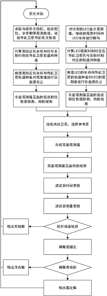
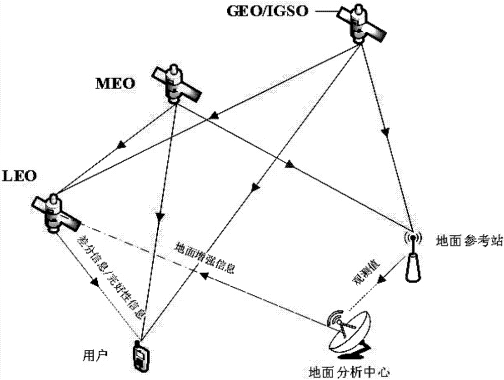
[0090] The satellite-earth difference real-time precise positioning method based on low-orbit satellites provided by the embodiment of the present invention uses low-orbit satellites as reference stations to communicate with receivers in ground or near-earth space. Carry out differential positioning; the low-orbit satellite uses the forecasted navigation satellite ephemeris and clock error noted on the ground to perform ground-enhanced precise autonomous orbit determination on the sate...


PUM


Abstract

The invention belongs to the satellite navigation and positioning technical field and discloses a low earth orbit satellite-based satellite-earth differential real-time precise positioning method. A low earth orbit satellite is utilized to broadcast the observation data and real-time orbit data of the satellite-borne GNSS (Global Navigation Satellite System) receiver of the low earth orbit satellite to the ground; and after receiving the differential information broadcasted by the low earth orbit satellite, a ground receiver generates a double-difference observation value consisting of the differential information and a local GNSS observation value and performs pseudorange-based moving base station DGNSS (Differential Navigation Satellite System) positioning and carrier phase-based moving base station RTK (Rea-time kinematic) positioning. According to the positioning method of the invention, the global mobile low earth orbit satellite platform is adopted as a reference station, so that real-time precision differential positioning service in the whole world can be realized, and the method does not depend on the distribution of ground reference stations; and a user can realize differential real-time precise positioning just through using a single receiver, and therefore, the method is free of operating range restrictions, and data communication links are not required to be considered.

Description

technical field [0001] The invention belongs to the technical field of satellite navigation and positioning, and in particular relates to a real-time precise positioning method based on low-orbit satellite-ground difference. Background technique [0002] The satellite navigation and positioning system (GNSS) can provide real-time positioning services around the world, which has profoundly changed our way of life, and has been widely used in many industries around the world. At present, the mainstream global positioning systems include GPS of the United States, GLONASS of Russia, Beidou system of China and Galileo system of Europe. India is also actively developing the regional navigation system IRNSS. The current standard GNSS positioning technology accuracy is about 5-10 meters. For applications requiring higher precision, precision positioning methods are usually required. At present, the methods of precise positioning include differential positioning method and precise ...

Claims


Application Information

Patent Timeline
IPC IPC(8): G01S19/41G01S19/42
Inventor 王磊陈锐志李德仁潘元进李明陈亮柳景斌
Owner WUHAN UNIV
Why Eureka
Try Eureka