Dual-use intelligent navigation system based on multimode synergic effect

A technology of intelligent navigation and navigation system, applied in the field of dual-purpose intelligent navigation systems for military and civilian purposes, can solve problems such as reference node lockout, error accumulation, and navigation accuracy decline, and achieve the effects of improving efficiency, reducing costs, and high navigation accuracy.

Inactive Publication Date: 2017-10-10
高武保
View PDF6 Cites 12 Cited by
  • Summary
  • Abstract
  • Description
  • Claims
  • Application Information

AI Technical Summary

Problems solved by technology

In order to overcome the shortcomings of the above two navigation methods that require reference nodes and are prone to loss of lock, scholars proposed to apply inertial measurement unit (IMU) to the field of small area target tracking.
IMU has the advantage

Method used


Image

  • Dual-use intelligent navigation system based on multimode synergic effect
  • Dual-use intelligent navigation system based on multimode synergic effect

Examples


Embodiment Construction

[0033] The present invention will be further described in detail below in conjunction with the accompanying drawings.

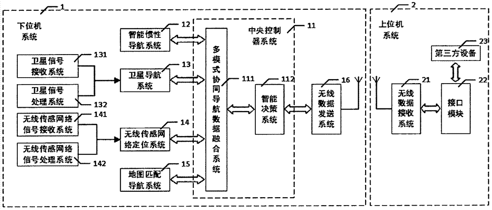
[0034] See figure 1 , figure 2 As shown, the present invention is a military-civil dual-purpose intelligent navigation system based on multi-mode coordination. This system is based on a navigation system integrated with inertial navigation and step counting zero-speed correction algorithm, with satellite navigation system, map matching navigation system and a wireless sensor network positioning system as a multi-mode collaborative three-dimensional intelligent navigation system; the present invention includes a lower computer system 1 and an upper computer system 2; the lower computer system 1 in the present invention includes a central controller system 11, an intelligent Inertial navigation system 12, satellite navigation system 13, wireless sensor network positioning system 14, map matching navigation system 15 and wireless data sending system 16; Host c...


PUM


Abstract

The invention discloses a dual-use intelligent navigation system based on a multimode synergic effect. The system is a multimode synergic three-dimensional intelligent accurate navigation positioning system on the basis of a navigation system fused with inertial navigation and step-counting zero-speed correcting algorithm and complemented by a satellite navigation system, a map matching navigation system and a wireless sensor network positioning system. A parallel real-time operation system is adopted by the invention for realizing the task scheduling, the real-time step-counting zero-speed correcting algorithm is adopted for correcting the speed and position errors of the inertial navigation system, a navigation method which consumes the lowest power and meets the precision requirement is intelligently selected from various fusion positioning techniques and is used for correcting the position error of the calibration system and the individual indoor/outdoor seamless three-dimensional accurate positioning is realized; the chip-scale circuit design is adopted by the invention, various navigation sub-systems are integrated and packaged into a patch device and the embedded development can be conveniently performed; the dual-use intelligent navigation system can supply higher safety guarantee to individual combat, police on duty, fire control, emergency and disaster releasing in the military field, can help the user to quickly plan a target route in the places, such as, shopping malls, airports, stations, parking lots, zones, scenic areas, museums, nursing home and hospitals in the civil use field, can interact with the user in real time and can perform accurate navigation and guidance, so that the user experience is promoted, the efficiency is greatly increased and the application value is higher.

Description

technical field [0001] The invention belongs to the technical field of integrated navigation in complex environments, in particular to a military-civil dual-purpose intelligent navigation system based on multi-mode coordination. Background technique [0002] In recent years, Pedestrian Navigation (PN), as an emerging field of navigation technology application, is receiving more and more attention from scholars from all over the world, and has gradually become a research hotspot in this field. However, in indoor environments such as large shopping malls, supermarkets, tunnels, warehouses, and underground parking lots, factors such as weak external radio signals and strong electromagnetic interference will have a great impact on the accuracy, real-time performance, and robustness of target pedestrian navigation information acquisition. . How to effectively integrate the limited information acquired in the indoor environment to eliminate the influence of the indoor complex env...

Claims


Application Information

Patent Timeline
IPC IPC(8): G01C21/16G01C21/18G01S19/46G01S19/47
CPCG01C21/165G01C21/18G01S19/46G01S19/47
Inventor 郭仲林高武保
Owner 高武保
Why Eureka
Try Eureka