Spatial-temporal pattern mining method based on variable-granularity fast GeoHash encoding

A technology of pattern mining and variable granularity, applied in the field of computer algorithms, can solve the problem that the coding unit cannot meet the flexible local to overall granularity change, is not conducive to the extraction of consistent feature space units, and the coding is not uniform. The effect of removing redundancy, reducing the amount of calculation, and fast speed

Inactive Publication Date: 2017-10-20
WUHAN UNIV
View PDF0 Cites 12 Cited by
  • Summary
  • Abstract
  • Description
  • Claims
  • Application Information

AI Technical Summary

Problems solved by technology

[0006] However, there are problems in GeoHash itself: the five-bit one encoding method causes the encoding of children and parents to be unevenly discrete and cannot be standardized (that is, when the child is assumed to be a square, the parent must be a rectangle), which is not conducive to the extraction of spatial units with consistent characteristics.
Fixed encoding units cannot accommodate flexible local-to-global granularity changes

Method used


Image

  • Spatial-temporal pattern mining method based on variable-granularity fast GeoHash encoding
  • Spatial-temporal pattern mining method based on variable-granularity fast GeoHash encoding

Examples


Embodiment Construction

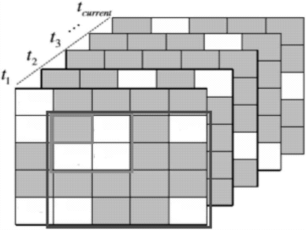
[0032] One, at first introduce the concrete method of the present invention, comprise:

[0033] Step 1: Improve GeoHash to encode geographic information. Usually, GeoHash encodes every 5 digits, which is very unfavorable for building hierarchical indexes of geographic information and exploring the relationship of different levels. After determining the maximum accuracy required, first determine the granularity of latitude and longitude encoding. 2 When it is divided into 16 digits, the longitude accuracy in China is about 400m. When it is divided into 16 digits, the latitude accuracy is 305 meters. ). We use this as the smallest unit of event registration, and generate up to 12,000 data areas in Shanghai.

[0034] Secondly, the code is compressed. In order to quickly retrieve and represent the region, 4 times zoom is used to encode the two-digit latitude and two-digit longitude in hexadecimal, which is more than double the decoding speed of the original 32-digit dislocation c...


PUM


Abstract

The invention belongs to the field of computer algorithms, and particularly relates to a spatial-temporal pattern mining method based on variable-granularity fast GeoHash encoding. The method comprises the steps that firstly, geographic information is encoded through improved geohash; secondly, a multi-level inquiry tree is constructed; thirdly, large-scale unit time spatial patterns are counted; fourthly, data of spatial-temporal patterns (such as volcanic and black hole patterns) is counted. According to the method, GeoHash encoding is improved, a variable-granularity fast GeoHash encoding scheme is disclosed, GeoHash is a kind of address encoding and can convert a two-dimensional longitude and latitude into a character string which can be used for comparison sorting and comparison, and in practical application, the method is more efficient than direct use of the longitude and latitude.

Description

technical field [0001] The invention belongs to the field of computer algorithms, in particular to a space-time pattern mining method based on variable granularity fast GeoHash coding. Background technique [0002] A spatiotemporal graph (STG) is a directed graph in which vertices and edges have geospatial locations and spatial lengths, respectively, and are associated with spatiotemporal attributes. Different types of human activity data, such as taxi traffic, subway card swiping data, bicycle movement data, and call detail records (CDR), can be modeled by a space-time graph (STG). Spatiotemporal graph mining is a branch of spatiotemporal data mining. [0003] Spatio-temporal data mining is a hot research field, and related research results are very rich. Mathioudakis et al. (M. Mathioudakis, N. Bansal, and N. Koudas. Identifying, attributing and describing spatial bursts. PVLDB, 3(1-2): 1091–1102, 2010.) introduced a scalable self-published Algorithms for mining spatial...

Claims


Application Information

Patent Timeline
Patent Type & Authority Applications(China)
IPC IPC(8): G06F17/30
CPCG06F16/2237G06F16/2465G06F16/29
Inventor 洪亮熊燚铭蔡明师任秋圜
Owner WUHAN UNIV
Why Eureka
Try Eureka