Method for suppressing false sea surface target based on digital elevation map

A digital elevation and target technology, applied to radio wave measurement systems, instruments, etc., can solve the problems of many signal processing targets, affecting radar processing and observation, and the impact of radar digital targets, so as to improve detection efficiency and reduce the impact of false targets. Effect

Active Publication Date: 2017-11-10
LEIHUA ELECTRONICS TECH RES INST AVIATION IND OF CHINA
View PDF3 Cites 7 Cited by
  • Summary
  • Abstract
  • Description
  • Claims
  • Application Information

AI Technical Summary

Problems solved by technology

[0003] In the airborne radar detection of sea targets (such as ships, warships, etc.) It is particularly strong, resulting in a large number of targets generated by signal processing, which has a great impact on the generation of subsequent radar digital targets. It is easy to saturate the number of targets and affect the subsequent processing and observation of the radar. Therefore, it is very difficult to suppress targets on the mainland and large and medium-sized islands. Needed
In order to suppress false targets on land or islands, the method of signal processing is currently used to estimate the coastline, and then suppress the targets within the coastline, but this method has high requirements for the environment (mainly sea conditions), and the difficulty of the algorithm itself , the error is relatively large, and the maximum error reaches the order of 10km, which has great shortcomings in actual use; there is another method to suppress the target using a flat digital map combined with aircraft navigation data, but this method has limitations

Method used


Image

  • Method for suppressing false sea surface target based on digital elevation map

Examples


Embodiment Construction

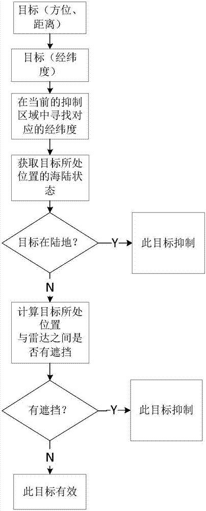
[0023] In order to make the objectives, technical solutions and advantages of the present invention clearer, the technical solutions in the embodiments of the present invention will be described in more detail below in conjunction with the drawings in the embodiments of the present invention. In the drawings, the same or similar reference numerals denote the same or similar elements or elements having the same or similar functions throughout. The described embodiments are some, but not all, embodiments of the invention. The embodiments described below by referring to the figures are exemplary and are intended to explain the present invention and should not be construed as limiting the present invention. Based on the embodiments of the present invention, all other embodiments obtained by persons of ordinary skill in the art without creative efforts fall within the protection scope of the present invention. Embodiments of the present invention will be described in detail below ...


PUM


Abstract

The invention discloses a method for suppressing a false sea surface target based on a digital elevation map and belongs to the field of airborne radars. The method comprises the following steps of 1, carrying out fragmentation treatment on a digital elevation map and storing the map; 2, according to the position of a current aircraft, the radar range and the processed storage data of the digital elevation map, loading terrain data in a local area and forming a corresponding suppressed terrain area; 3, according to the attitude and the target parameter of the aircraft, calculating the longitude and the latitude of a target; 4, acquiring the sea-land state of a position wherein the target is located; 5, performing suppression judgment according to the obtained altitude of the target and the height of the sea level. According to the method for suppressing the false sea surface target based on the digital elevation map, the limitation problem of suppressing a land false target based on a plane digital map can be solved, so that the influence of the radar on the false target during the sea detection process is effectively reduced. The detection efficiency is improved.

Description

technical field [0001] The invention belongs to the technical field of aviation airborne radar, in particular to a method for suppressing false sea surface targets based on a digital elevation map. Background technique [0002] Digital elevation map DEM is a digital representation of regional terrain. It is organized by a series of ground point positions and their associated elevation z according to a certain structure, indicating the spatial distribution characteristics of the actual terrain. It is an important part of the spatial information system. . Generally, the DEM data model can be divided into three types: contour line representation, regular grid (GRID) representation and irregular triangle (TIN) representation, and they can be transformed into each other. At present, there is no uniform standard for DEM data files. The widely used DEM data is the 90m resolution DEM data obtained by the US space shuttle radar topography mission (SRTM). [0003] In the airborne ra...

Claims


Application Information

Patent Timeline
Patent Type & Authority Applications(China)
IPC IPC(8): G01S7/36G01S7/41
CPCG01S7/36G01S7/41
Inventor 刘心刚鲍中袁轩
Owner LEIHUA ELECTRONICS TECH RES INST AVIATION IND OF CHINA
Why Eureka
Try Eureka