Unmanned aerial vehicle intelligent perception system and method based on multiple sensors

An intelligent perception, multi-sensor technology, applied in the field of computer vision, can solve the problems of unstable GPS signal, low positioning accuracy, signal occlusion, etc., to achieve the effect of fast calculation, high real-time performance and small amount of calculation

Inactive Publication Date: 2017-12-08
TIANJIN UNIV
View PDF8 Cites 64 Cited by
  • Summary
  • Abstract
  • Description
  • Claims
  • Application Information

AI Technical Summary

Problems solved by technology

The traditional UAV positioning method uses global satellite navigation and positioning systems such as GPS and Beidou. The positioning accuracy is low and the

Method used


Image

  • Unmanned aerial vehicle intelligent perception system and method based on multiple sensors
  • Unmanned aerial vehicle intelligent perception system and method based on multiple sensors
  • Unmanned aerial vehicle intelligent perception system and method based on multiple sensors

Examples


Embodiment Construction

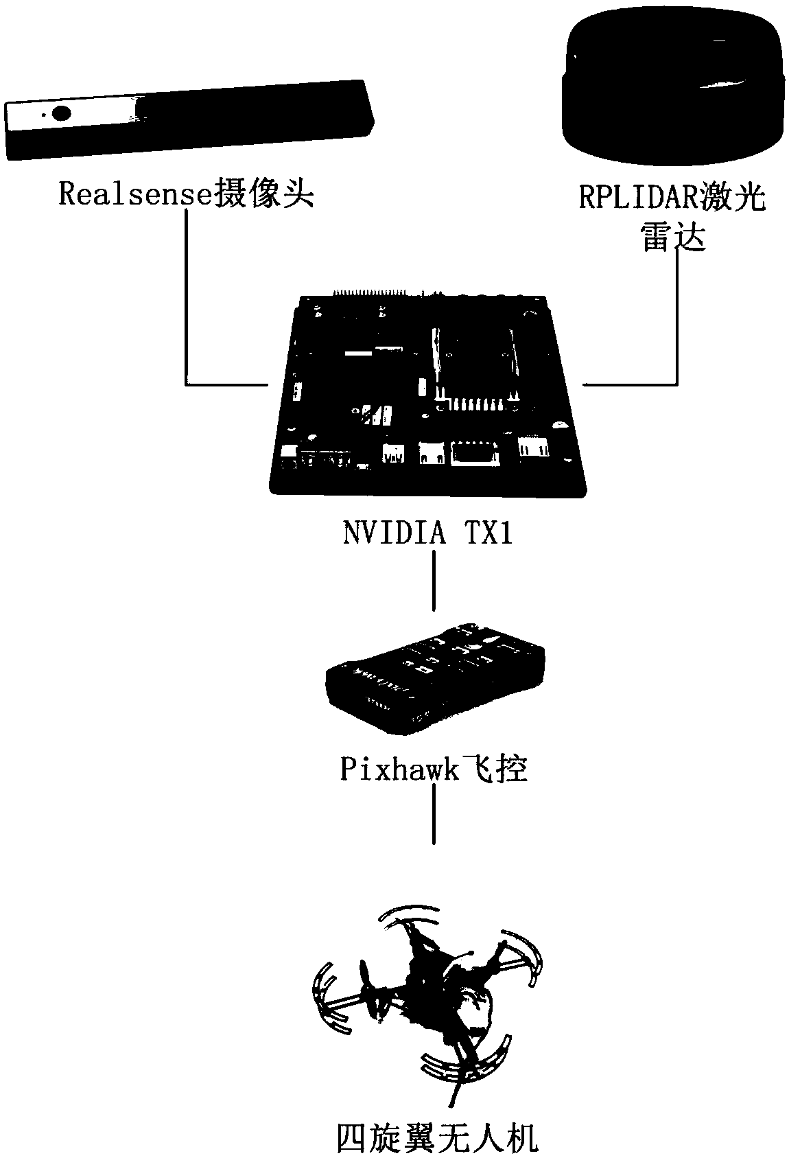
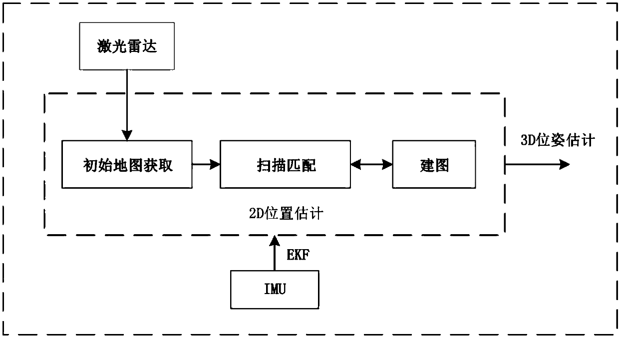
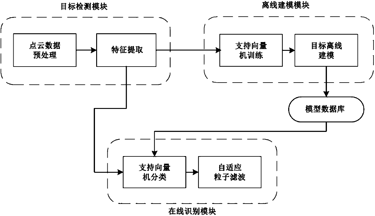
[0036]The multi-sensor based UAV intelligent perception system proposed by the present invention mainly includes laser radar, RGB-D visual sensor, IMU inertial measurement unit, embedded onboard processor and flight controller. LiDAR is mainly used to measure the distance information of the surrounding environment, with high measurement accuracy, large coverage, and strong anti-interference; RGB-D visual sensor can collect distance information and image information of the surrounding environment. The lidar collects 2D point cloud data, while the RGB-D vision sensor collects 3D point cloud data. The point cloud data contains richer feature information of the target object, which can improve the robustness of the target recognition system. The IMU inertial measurement unit is a device for measuring its own three-axis attitude angle and acceleration. The present invention directly uses the IMU sensor in the flight controller. The flight controller is mainly used to stabilize the ...


PUM


Abstract

The invention relates to a sensor and unmanned aerial vehicle intelligent perception control technology, so as to realize the intelligent perception of an unmanned aerial vehicle to the surrounding environment. The system can verify other autonomous localization algorithms and target recognition algorithms to improve the research efficiency of the intelligent perception technology. According to the unmanned aerial vehicle intelligent perception system and method based on multiple sensors, the system comprises a laser radar, an RGB-D visual sensor, an IMU inertial measurement unit, an embedded airborne processor and a flight controller; the laser radar is used to measure the distance information of the surrounding environment; the RGB-D visual sensor collects the distance information and image information of the surrounding environment; the laser radar collects 2D point cloud data, while the RGB-D visual sensor collects 3D point cloud data; the IMU inertial measurement unit is a device which measures the three-axis attitude angle and the acceleration of the device; and the embedded airborne processor comprises two independent modules of autonomous positioning and target recognition. The unmanned aerial vehicle intelligent perception system and method based on multiple sensors are mainly used for unmanned aerial vehicle control.

Description

technical field [0001] The present invention relates to the fields of computer vision, sensors, embedded systems and unmanned aerial vehicles, in particular to a multi-sensor-based intelligent perception system for unmanned aerial vehicles. Specifically, it involves the intelligent perception system of UAV based on multi-sensors. Background technique [0002] A drone is a remote or programmed unmanned aircraft. In recent years, due to its broad application prospects in military and civilian fields, quadrotor UAVs have attracted widespread attention; quadrotor UAVs have the advantages of small size, light weight, strong mobility, simple structure, and good safety. And other advantages, which makes UAVs play an important role in practical tasks such as terrain mapping, aerial photography, target tracking and monitoring, and disaster rescue. Therefore, with the development of UAV-related technologies and the complexity of application scenarios, it is particularly critical to ...

Claims


Application Information

Patent Timeline
IPC IPC(8): G05D1/08G05D1/10
CPCG05D1/0808G05D1/101
Inventor 宗群陈扬刘朋浩董琦刘彤
Owner TIANJIN UNIV
Why Eureka
Try Eureka