Method for rapidly constructing three-dimensional terrain model by use of unmanned aerial vehicle for multi-view camera shooting

A 3D terrain and UAV technology, applied in 3D modeling, image data processing, photogrammetry/video metrology, etc., can solve problems such as the inability to meet the construction of high-quality 3D models, achieve accurate flight and shooting, reduce Complexity, the effect of reducing time cost

Active Publication Date: 2017-12-22
TIANJIN UNIV
View PDF4 Cites 37 Cited by
  • Summary
  • Abstract
  • Description
  • Claims
  • Application Information

AI Technical Summary

Problems solved by technology

However, the general single-angle measurement cannot meet the requirements for building high-quality 3D models. The traditional solution is to carry multiple angle cameras on a drone, which undoubtedly increases the requirements for the load capacity of the drone.

Method used


Image

  • Method for rapidly constructing three-dimensional terrain model by use of unmanned aerial vehicle for multi-view camera shooting
  • Method for rapidly constructing three-dimensional terrain model by use of unmanned aerial vehicle for multi-view camera shooting
  • Method for rapidly constructing three-dimensional terrain model by use of unmanned aerial vehicle for multi-view camera shooting

Examples


Embodiment 1

[0045] The embodiment of the present invention provides a method for quickly constructing a three-dimensional terrain model by using the multi-view camera of the UAV. The method utilizes the spatial flexibility of the UAV to realize high-altitude multi-angle photogrammetry, and has a high degree of automation and a large measurement range. Large size, low cost, and convenient operation. Taking topographic surveying and mapping of a certain area as an example, the above method includes the following steps:

[0046] 101: Collect regional terrain information that needs to be surveyed and mapped; according to the regional terrain information, select the type of drone for aerial photography;

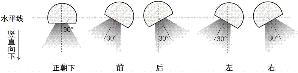
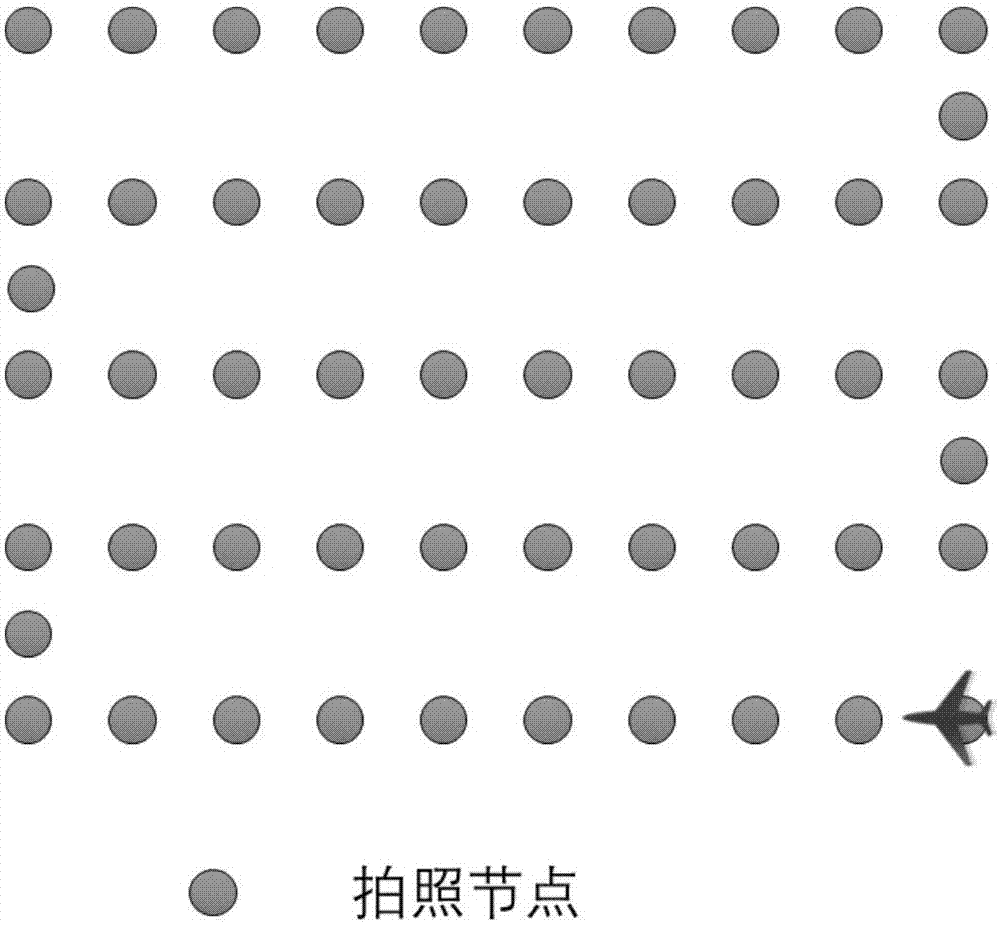
[0047] 102: Use the control software to upload the flight mission to the UAV, so that it can fly according to the predetermined flight height and flight trajectory, and take multi-angle shots of the ground at the same time;

[0048] 103: Process the collected pictures with 3D model generatio...

Embodiment 2

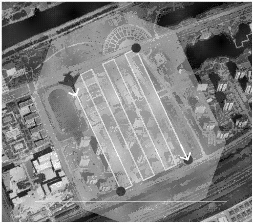
[0056] Combine below Figure 1-Figure 4 , and examples further introduce the scheme in embodiment 1, see the following description for details:

[0057] 201: Collect topographical information of the area that needs to be surveyed and mapped;

[0058] The terrain information of the above-mentioned area includes: the size of the surveying and mapping area, whether there are tall buildings, in order to ensure safety, it is also necessary to know the flow of people nearby, whether there is an open area suitable for aircraft to take off and land, etc.

[0059] During specific implementation, the embodiment of the present invention does not limit the specific types and quantities of the above-mentioned information, which are selected according to requirements in practical applications.

[0060] 202: According to the regional terrain information, select the type of drone for aerial shooting;

[0061] Among them, the appropriate number of UAVs and batteries should be selected accord...


PUM


Abstract

The invention discloses a method for rapidly constructing a three-dimensional terrain model by use of an unmanned aerial vehicle for multi-view camera shooting, the method comprises the following steps: collecting terrain information of a region to be surveyed; selecting a type of the unmanned aerial vehicle for aerial camera shooting according to the terrain information of the region; using control software to upload a flight mission to the unmanned aerial vehicle to enable the unmanned aerial vehicle to fly according to a predetermined flight altitude and flight path and meanwhile shoot the ground from multiple perspectives; using 3D model generation software to process collected images to reconstruct the three-dimensional model of the shot region. By use of the flying stability and flexibility of the multi-rotor unmanned aerial vehicle, low-altitude remote sensing measurement can be performed based on the theory of three-dimensional reconstruction of the images, automation and intelligence of a geographic mapping process can be realized through flight path planning and multi-view camera shooting of the unmanned aerial vehicle, precision and efficiency of geo-mapping can be improved, the workload in the geo-mapping is greatly reduced, and the method has the advantages of high degree of automation, large measuring range, low cost and convenient operation and the like.

Description

technical field [0001] The invention relates to the field of three-dimensional digital terrain reconstruction, in particular to a method for collecting ground images and constructing a three-dimensional terrain model by using an unmanned aerial vehicle. Background technique [0002] Image-based 3D reconstruction is a method to restore 3D models of objects and scenes from several 2D images. This method involves many disciplines such as computer image processing, computer graphics, computer vision and pattern recognition. Compared with the traditional method of using modeling software or 3D scanner to obtain a three-dimensional model, the method based on image 3D reconstruction has low cost, strong sense of reality, and high degree of automation, so it has broad application prospects. At present, this technology has become a research hotspot in 3D reconstruction. [0003] The basic process of image-based 3D terrain reconstruction method is to use the camera to take a series ...

Claims


Application Information

Patent Timeline
Patent Type & Authority Applications(China)
IPC IPC(8): G01C11/00G06T17/05
CPCG01C11/00G06T17/05
Inventor 薛彬张凯赵拓王志洋游画丁微刘雪枫许思阳李冰杨李静静
Owner TIANJIN UNIV
Why Eureka
Try Eureka