Method for measuring soil compaction degree based on ground penetrating radar

A ground-penetrating radar and soil technology, applied in the field of geological exploration, can solve the problems of damage to soil, time-consuming and labor-intensive, etc., and achieve the effect of simple and accurate measurement

Inactive Publication Date: 2018-01-12
QUFU NORMAL UNIV
View PDF4 Cites 33 Cited by
  • Summary
  • Abstract
  • Description
  • Claims
  • Application Information

AI Technical Summary

Problems solved by technology

However, the damage to the soil during the sample collection process is relatively serious, and it is time-consuming and labor-intensive; skilled manual operation is required, and it is greatly affected by human factors.

Method used


Image

  • Method for measuring soil compaction degree based on ground penetrating radar
  • Method for measuring soil compaction degree based on ground penetrating radar
  • Method for measuring soil compaction degree based on ground penetrating radar

Examples


Embodiment

[0025] A method for measuring soil compaction degree based on ground penetrating radar, said method may further comprise the steps:

[0026] The ground penetrating radar profile method with a center frequency of 500MHz is used for measurement, the time window is set to 20-50ns, the sampling time interval is 0.2ns, and the sampling space interval is 0.01m;

[0027] Signal processing includes: DC offset setting 500, saturation signal correction, zero point correction, and the use of exponential compensation gain, band-pass filter, vertical filter, median filter, spatial low-pass filter, and offset filter according to the actual situation.

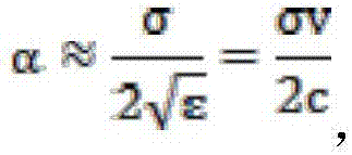
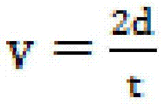
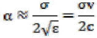
[0028] Electromagnetic wave propagation velocity extraction: The extraction of electromagnetic wave velocity between layers first needs to determine the soil layer interface and depth, and then read the two-way travel time of electromagnetic waves in the soil layer and substitute it into the formula

[0029]

[0030] Among them, v represen...


PUM

PropertyMeasurementUnit
frequencyaaaaaaaaaa
electrical conductivityaaaaaaaaaa

Abstract

The invention discloses a method for measuring soil compaction degree based on ground penetrating radar. The method comprises the following steps: adopting a ground penetrating radar cross-section method to measure the volume weight of soil; processing an acquired measurement signal, and defining a zero point measured by an electromagnetic wave to obtain accurate time domain information; extracting electromagnetic wave propagation speed, and establishing a regression equation of reverting the volume weight of soil in combination with the electromagnetic wave propagation speed and other soil factors; extracting the amplitude of the electromagnetic wave, using the correlation between the amplitude energy value of the electromagnetic wave and soil penetration resistance to proof the feasibility of the soil compaction degree measured by the ground penetrating radar; calculating the decay rate of the electromagnetic wave, using the correlation between the decay factor of the electromagneticwave and the soil penetration resistance to proof the feasibility of the soil compaction degree measured by the ground penetrating radar; using the average speed of propagation of the electromagneticwave to calculate the average volume weight of a soil body, and using the amplitude of the electromagnetic wave and the decay factor to reflect the characteristic that the soil compaction degree gradually changes along with the depth. The method disclosed by the invention is accurate, simple and fast.

Description

technical field [0001] The invention relates to the field of geological exploration, in particular to a method for measuring soil compaction degree based on ground penetrating radar. Background technique [0002] Since the 20th century, the level of agricultural mechanization has improved, and the use of large machinery and its supporting equipment has grown rapidly. Soil mechanical compaction has increasingly become the main problem faced by modern agriculture. Soil compaction results in poor soil nutrients in the top layer, and the soil quality is more and more prone to degradation. [0003] Commonly used factors to reflect soil compaction include soil bulk density and soil penetration resistance. However, the damage to the soil during the sample collection process is relatively serious, and it is time-consuming and labor-intensive; skilled manual operation is required, and it is greatly affected by human factors. Contents of the invention [0004] In view of this, an ...

Claims


Application Information

Patent Timeline
Patent Type & Authority Applications(China)
IPC IPC(8): G01N22/00G01S13/88
Inventor 王萍
Owner QUFU NORMAL UNIV
Why Eureka
Try Eureka