Eureka AIR delivers breakthrough ideas for toughest innovation challenges, trusted by R&D personnel around the world.

A Structure-Driven Spectral Mapping Remote Sensing Image Fusion Method

A technology of remote sensing image fusion and multi-spectral imagery, which is applied in the field of remote sensing image processing and can solve problems such as spectral distortion.

Active Publication Date: 2020-12-15
BEIHANG UNIV
View PDF3 Cites 0 Cited by
  • Summary
  • Abstract
  • Description
  • Claims
  • Application Information

AI Technical Summary

Problems solved by technology

[0006] Aiming at the spectral distortion problem existing in the existing fusion algorithm, the present invention provides a structure-driven spectral mapping remote sensing image fusion method

Method used


Image

  • A Structure-Driven Spectral Mapping Remote Sensing Image Fusion Method
  • A Structure-Driven Spectral Mapping Remote Sensing Image Fusion Method
  • A Structure-Driven Spectral Mapping Remote Sensing Image Fusion Method

Examples


Embodiment Construction

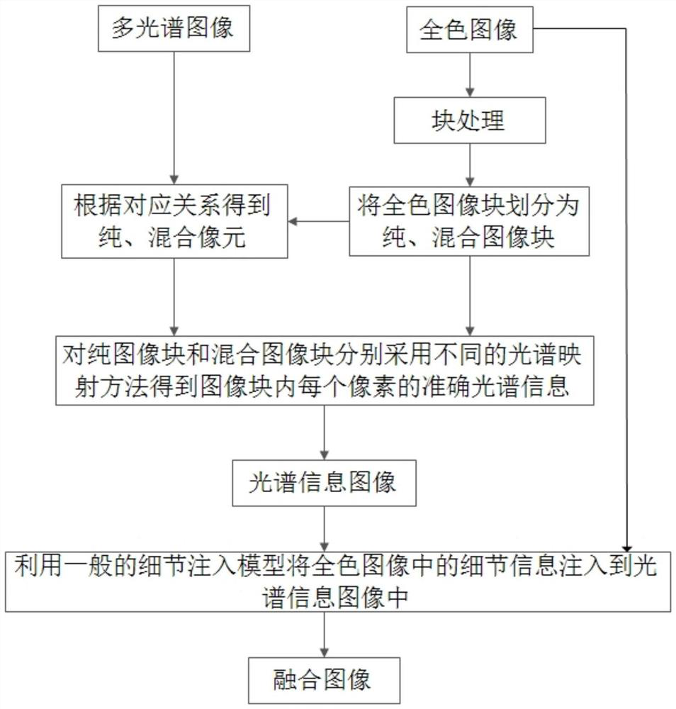
[0015] In order to better understand the technical solution of the present invention, the present invention will be described in detail below in conjunction with the accompanying drawings and specific embodiments. The concrete realization process of the present invention is as figure 1 As shown, the specific implementation details of each part are as follows:

[0016] Step 1: Perform block processing on the panchromatic image, and establish the corresponding relationship between image blocks and multispectral image pixels. And each image block is divided into pure or mixed image blocks according to its own spatial characteristics and its relationship with neighboring images, so as to determine the pure and mixed attributes of the corresponding multispectral image pixels.

[0017] Step 1-1: Calculate the resolution ratio r between the panchromatic image and the multispectral image, and perform block processing on the panchromatic image according to r, the size of each image bl...


PUM


Abstract

The invention discloses a structure-driven spectrally mapped remote sensing image fusion method, and belongs to the technical field of remote sensing image processing. The method is implemented by comprising the steps of 1) performing block processing on a full-color image, establishing a corresponding relationship between full-color image blocks and multispectral image pixels, and according to spatial characteristics of the image blocks and a relationship between the image blocks and a neighborhood image, classifying the image blocks into pure or mixed image blocks, thereby determining corresponding pure and mixed attributes of the multispectral image pixels; 2) performing spectral information mapping on the pure and mixed image blocks by adopting different methods to obtain a spectral information image; and 3) injecting detail information into the spectral information image by adopting a general detail extraction method to obtain a fused image. Based on structural analysis on the full-color image, the accuracy of spectral information of the pixels is ensured; the phenomena of ghosts and the like in the general fused image can be improved; and the method can be used in the fieldsof environment monitoring, land utilization, agricultural investigation and the like.

Description

technical field [0001] The invention belongs to the field of remote sensing image processing, in particular to a structure-driven spectral mapping remote sensing image fusion method for fusion of panchromatic images and multispectral images. Background technique [0002] For panchromatic images and multispectral images acquired by satellites at the same location, due to some limitations of the sensor itself, their opposite characteristics are caused. Panchromatic images have higher spatial resolution and multispectral images have higher spectral resolution. Rate. Therefore, the fusion of panchromatic images and multispectral images to generate remote sensing images with both high spatial resolution and high spectral resolution can be used for better classification, feature extraction and change detection of remote sensing images. [0003] The basic implementation steps of the current fusion method can be summarized as follows: 1) Extract spatial detail information from panc...

Claims


Application Information

Patent Timeline
Patent Type & Authority Patents(China)
IPC IPC(8): G06T5/50G06T7/13
CPCG06T5/50G06T2207/10024G06T2207/10032G06T7/13
Inventor 罗晓燕周亮宇万寒尹继豪
Owner BEIHANG UNIV
Why Eureka
Eureka Blog
Learn More