Unmanned vehicle navigation positioning precision correcting method based on GNSS and VO combination

An unmanned vehicle, navigation and positioning technology, applied in the field of unmanned vehicle navigation and positioning accuracy correction, can solve the problems of poor reliability, low accuracy, and high cost of integrated navigation systems, and achieves low cost, improved reliability, and small size. Effect

Inactive Publication Date: 2018-02-23
NANJING UNIV OF AERONAUTICS & ASTRONAUTICS +1
View PDF4 Cites 22 Cited by
  • Summary
  • Abstract
  • Description
  • Claims
  • Application Information

AI Technical Summary

Problems solved by technology

[0004] The technical problem to be solved by the present invention is to provide an unmanned vehicle navigation and positioning accuracy correction meth

Method used


Image

  • Unmanned vehicle navigation positioning precision correcting method based on GNSS and VO combination
  • Unmanned vehicle navigation positioning precision correcting method based on GNSS and VO combination
  • Unmanned vehicle navigation positioning precision correcting method based on GNSS and VO combination

Examples


Embodiment Construction

[0023] Embodiments of the invention are described in detail below, examples of which are illustrated in the accompanying drawings. The embodiments described below by referring to the figures are exemplary only for explaining the present invention and should not be construed as limiting the present invention.

[0024] Such as Figure 4 As shown, the unmanned vehicle navigation and positioning accuracy correction method based on GNSS and VO fusion includes the following steps:

[0025] (1) Lane line detection based on monocular vision;

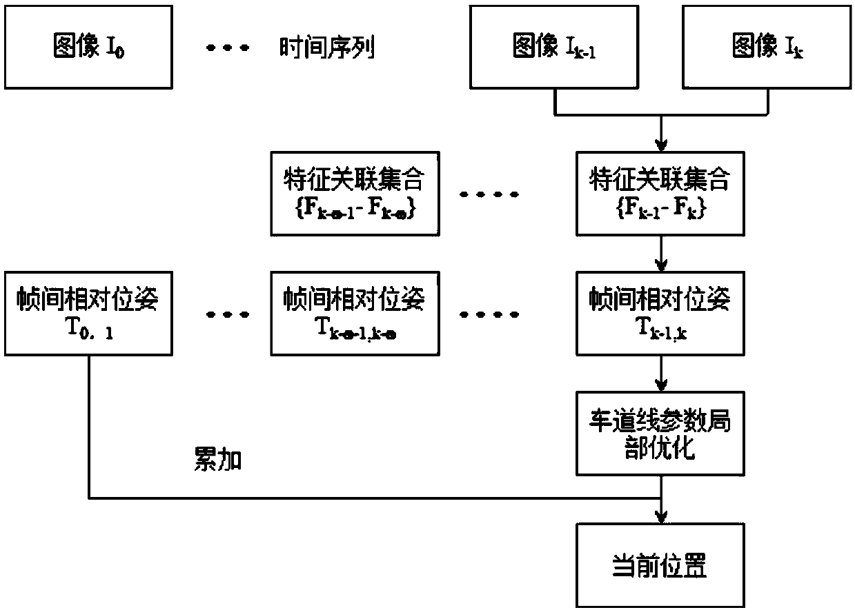
[0026] (2) Optimizing the positioning accuracy of the monocular visual odometer;

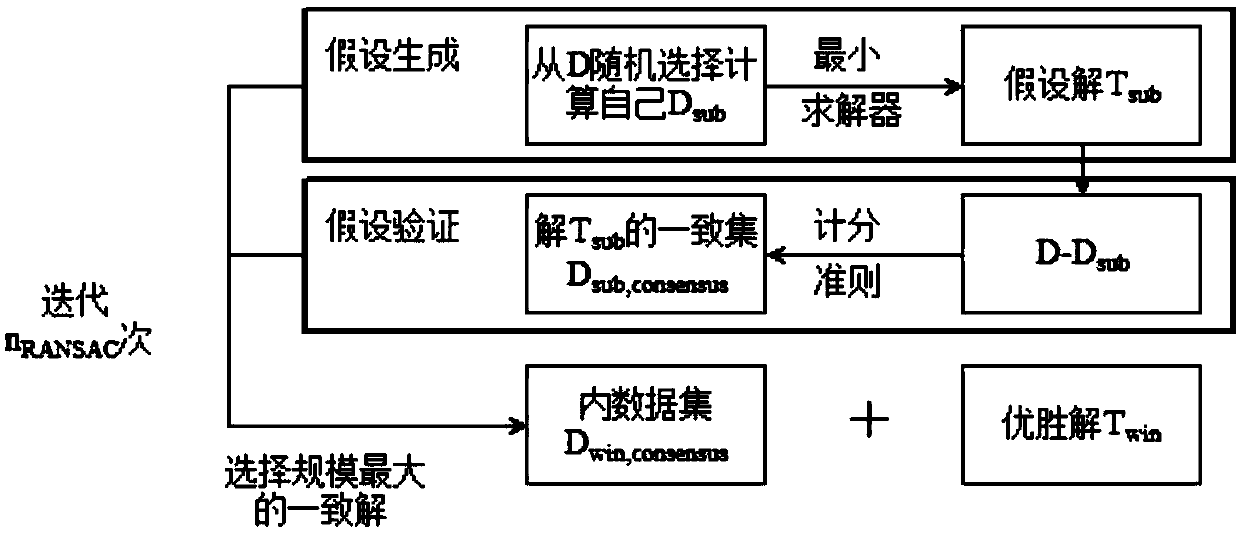
[0027] (3) Positioning accuracy correction of GNSS and visual odometer integrated navigation system.

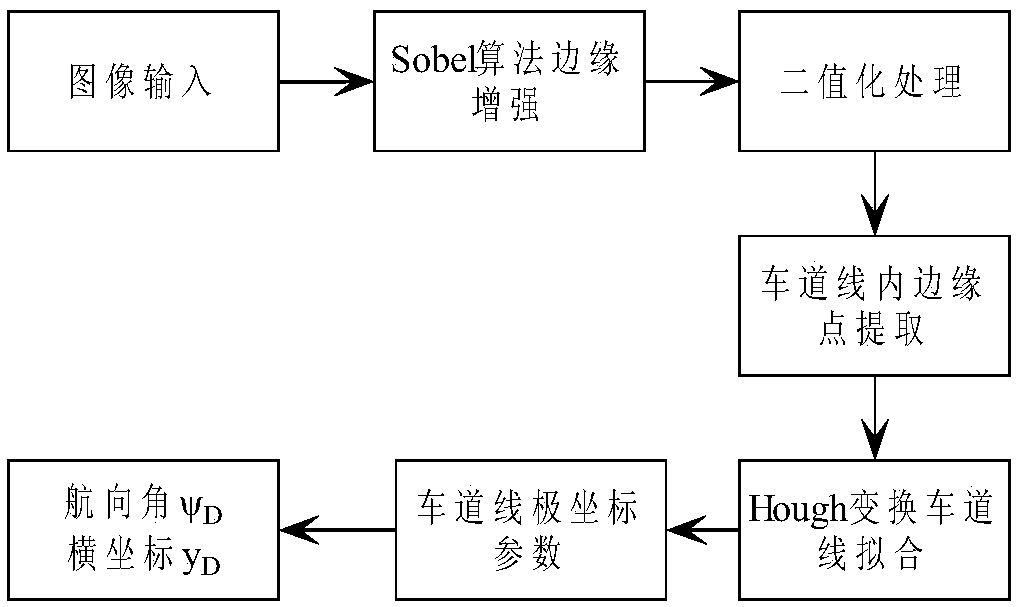
[0028] Such as figure 1 Shown is a flow chart of lane line detection in the present invention. The specific process is as follows: read a frame of image, process the image line by line, use the Sobel algorithm sensitive to the horizontal direction to enhance...


PUM


Abstract

The invention discloses an unmanned vehicle navigation positioning precision correcting method based on GNSS and VO combination. The method comprises the steps of (1) lane line detection based on monocular vision; (2) positioning precision optimization of a monocular vision mileometer; and (3) correcting the positioning precision of a GNSS/VO combined navigation system. According to the invention,the lane line auxiliary visual mileometer is used and combined with GNSS positioning to improve the reliability of a vehicle positioning system. The GNSS/ VO has strong complementary characteristics,the GNSS can obtain a long-time stable positioning result, and the VO can obtain short-term high-precision positioning data. The difference of the position measurement values is filtered and calculated by utilizing the two sensors. The error of a VO system is corrected by using an estimated value of the VO system error, so that the purpose of limiting the long-time drift of VO data by utilizing the GNSS data is achieved.

Description

technical field [0001] The invention relates to an unmanned vehicle navigation and positioning accuracy correction method based on GNSS and VO fusion, and belongs to the technical field of unmanned vehicle integrated navigation. Background technique [0002] With the popularity of cars and the increase in frequency of use, road congestion, environmental pollution and traffic accidents have become problems that people have to face. Developing unmanned vehicles and researching the autonomous driving system of vehicles is currently the best choice to achieve safe and efficient transportation. Positioning, as the key technology of unmanned vehicles, is an urgent problem to be solved in the current vehicle navigation system. The global satellite navigation system GNSS (GPS, GLONASS, Galileo, BeiDou) is often used in early vehicle positioning systems. GNSS can provide global, high-precision positioning services, but affected by satellite orbit errors, clock errors, and signal pr...

Claims


Application Information

Patent Timeline
IPC IPC(8): G01S19/40G01S19/45
CPCG01S19/40G01S19/45
Inventor 曾庆喜邱文旗冯玉朋李晓宇刘德辉徐纪洋
Owner NANJING UNIV OF AERONAUTICS & ASTRONAUTICS
Why Eureka
Try Eureka