Method and system for clustering movement tracks of vehicle objects in road network space

A technology for object movement and trajectory clustering, applied in the field of big data processing, can solve the problems of large gaps in the expected effect of clustering results and unsatisfactory results, and achieve the effect of improving the clustering effect.

Active Publication Date: 2018-03-06
北京泓达九通科技发展有限公司
View PDF12 Cites 55 Cited by
  • Summary
  • Abstract
  • Description
  • Claims
  • Application Information

AI Technical Summary

Problems solved by technology

[0004] Therefore, the defect in the prior art is: the existing clustering algorithm based on the track data of the floating car only considers the latitude

Method used


Image

  • Method and system for clustering movement tracks of vehicle objects in road network space
  • Method and system for clustering movement tracks of vehicle objects in road network space
  • Method and system for clustering movement tracks of vehicle objects in road network space

Examples


Embodiment 1

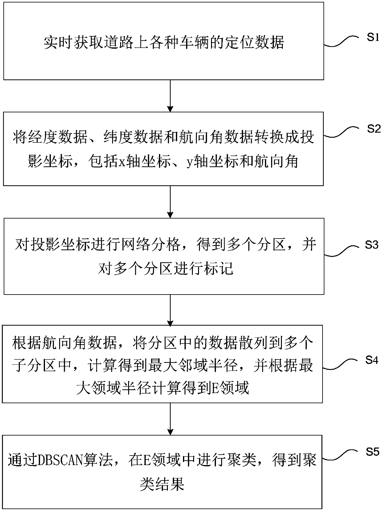
[0076] figure 1 It shows a flow chart of a method for clustering vehicle object moving trajectories in road network space provided by an embodiment of the present invention; figure 1 As shown, a method for clustering vehicle object moving trajectories in the road network space provided by Embodiment 1 includes:

[0077] Step S1, obtaining positioning data of various vehicles on the road in real time, including longitude data, latitude data and heading angle data;

[0078] Step S2, converting longitude data, latitude data and heading angle data into projected coordinates, including x-axis coordinates, y-axis coordinates and heading angles;

[0079] Among them, longitude lng is x i Coordinates, latitude lat is y i coordinates, the heading angle is di, and the projected coordinates are Pi={i ,y i >,di}.

[0080] Step S3, performing grid division on the projected coordinates to obtain multiple partitions, and marking the multiple partitions;

[0081] In order to improve effi...

Embodiment 2

[0171]As a preferred embodiment of the present invention, based on the method and system for clustering vehicle object moving trajectories in road network space in Embodiment 1, clustering is performed based on GPS data of various vehicles, wherein the GPS data of various vehicles can also be It directly reflects the road congestion situation. In the existing technology, the judgment of urban congestion situation is usually based on traditional traffic information detection equipment, which often has high installation and layout costs, high technical difficulty, and difficult maintenance and operation in the later stage, making it difficult to rely on these detection equipment The application range of the traffic congestion discrimination method based on equipment data has a problem of relatively large limitations. Based on this, the present embodiment is based on the GPS data of vehicle, carries out the discrimination of urban road congestion, and specific scheme is as follows...

Embodiment 3

[0220] As a preferred embodiment of the present invention, based on the method and system for clustering vehicle object moving trajectories in the road network space in the first embodiment, and the urban traffic jam discrimination method in the second embodiment, a large amount of vehicle GPS data must be collected in real time, For processing, when the urban congestion is analyzed based on vehicle GPS data, some abstract concepts in data analysis cannot be well represented, and it is difficult to display big data in a way that is easy for people to understand, and it cannot support real-time streaming data show. Based on this, this embodiment provides a visual data display side, and its technical solution is:

[0221] Data visual mining based on visualization technology, in the case of large-scale real-time data flow, the original vehicle GPS data is converted into a visual "fingerprint" data model through the data conversion module, that is, the original GPS data is process...


PUM


Abstract

The invention provides a method and system for clustering movement tracks of vehicle objects in road network space. The method includes acquiring positioning data of different vehicles on a road in real time, wherein the positioning data includes longitude data, latitude data and course angle data; converting the longitude data, the latitude data and the course angle data into projection coordinates including x-axis coordinates, y-axis coordinates and course angles; performing network gridding on the projection coordinates, obtaining a plurality of partitions and marking the partitions; dispersing data in each partition into a plurality of sub partitions according to the course angle data, obtaining the maximal radius of neighborhood through calculation and obtaining an E domain through calculation based on the maximal radius of neighborhood; performing clustering in the E domain through a DBSCAN algorithm and obtaining a clustering result. According to the invention, based on mass vehicle positioning data information, through improvement of the DBSCAN algorithm, course angles are added into the algorithm, so that the clustering effect can be improved substantially.

Description

technical field [0001] The invention relates to the field of big data processing, in particular to the field of a method and a system for clustering moving trajectories of vehicle objects in road network space. Background technique [0002] Directed density clustering is a method of mining traffic road network information from massive floating vehicle trajectories. Mining traffic geographic information (road network topology) based on floating vehicle trajectory data generally adopts the method of spatial clustering. Clustering is the The data set is divided into multiple meaningful clusters according to certain rules. The similarity in the same cluster is high, and the similarity between different clusters is low. Common clustering methods include hierarchical clustering, partition clustering, and grid clustering. classes, density methods, etc. [0003] Based on the characteristics of floating car data, the density method is used for clustering here. The density clustering...

Claims


Application Information

Patent Timeline
IPC IPC(8): G06K9/00G06K9/62
Inventor 巢坤常诚王川久王要伟刘方龙
Owner 北京泓达九通科技发展有限公司
Why Eureka
Try Eureka