Integrated navigation method based on vision and high-precision map lane line constraint

A technology of integrated navigation and lane lines, applied in the field of navigation, can solve the problem of low availability of vehicle integrated navigation algorithms, achieve the effects of optimizing algorithm performance and availability, improving usability, and improving performance

Active Publication Date: 2018-03-09
WUHAN UNIV +1
View PDF6 Cites 29 Cited by
  • Summary
  • Abstract
  • Description
  • Claims
  • Application Information

AI Technical Summary

Problems solved by technology

[0005] The embodiment of the present application provides an integrated navigation method based on vision and high-precision map lane line constraints, which solves the pr...

Method used


Image

  • Integrated navigation method based on vision and high-precision map lane line constraint
  • Integrated navigation method based on vision and high-precision map lane line constraint
  • Integrated navigation method based on vision and high-precision map lane line constraint

Examples


Embodiment Construction

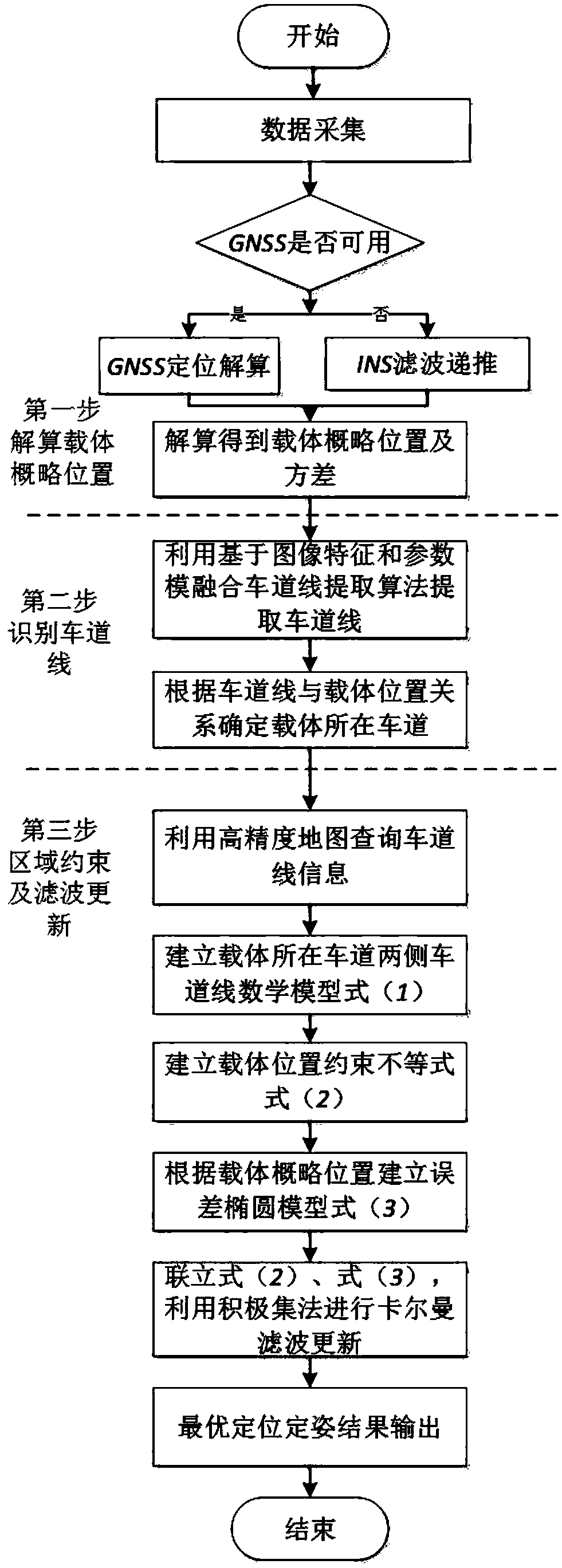
[0046] The embodiment of the present application provides an integrated navigation method based on vision and high-precision map lane line constraints, which solves the problem in the prior art that GNSS is susceptible to interference and occlusion in an urban environment, resulting in low availability of vehicle integrated navigation algorithms.

[0047] The technical solution of the embodiment of the present application is to solve the above-mentioned technical problems, and the general idea is as follows:

[0048] A combined navigation method based on visual and high-precision map lane line constraints, comprising the following steps:

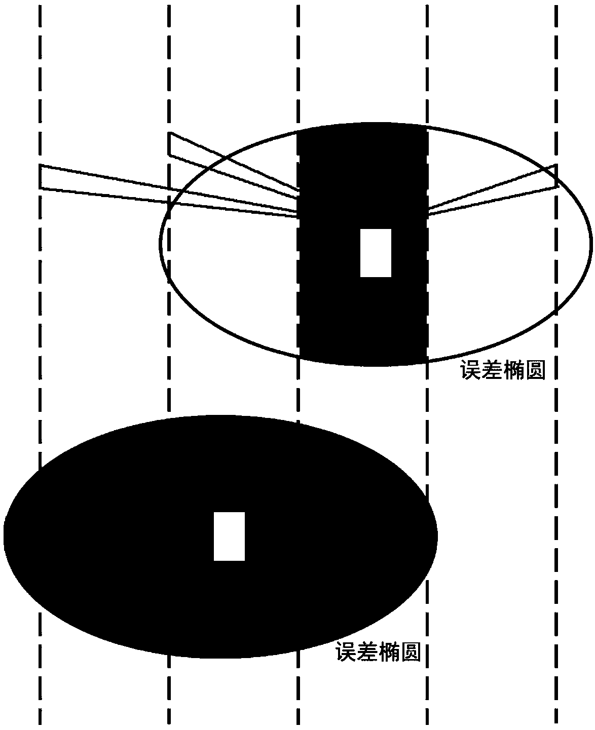
[0049] Step 1. Obtain the approximate position and accuracy evaluation index of the carrier through GNSS / INS integrated navigation and positioning;

[0050] Step 2. Recognize the lane line and determine the lane where the carrier is located through visual aids;

[0051] Step 3. Combining the high-precision map to form a carrier position are...


PUM


Abstract

The invention belongs to the technical field of navigation, and discloses an integrated navigation method based on vision and high-precision map lane line constraint. The integrated navigation methodincludes acquiring outline position and accuracy assessment indexes of a carrier through GNSS (global navigation satellite system)/INS (inertia navigation system) integrated navigating and positioning; recognizing lane lines and determining the lane line of the carrier by the aid of vision; forming a carrier position region constraint equation according to a high-precision map to assist integratednavigation filtering calculation. The integrated navigation method has the advantages that the problem of low usability of vehicle-mounted navigation algorithms due to interference and shielding of the GNSS in a city environment in the prior art is solved, and the technical effect of improving usability of the integrated navigation algorithm in the city environment is achieved.

Description

technical field [0001] The invention relates to the technical field of navigation, in particular to a combined navigation method based on vision and high-precision map lane line constraints. Background technique [0002] High-precision and high-reliability positioning and attitude determination algorithms are the basis for the development of vehicle-mounted mobile surveying and mapping and automatic driving industries. At present, the integrated navigation algorithm based on global satellite navigation system (GNSS) / inertial navigation system (INS) can provide continuous high-precision positioning and attitude determination results due to its advantages of integrating GNSS high-precision long-term positioning performance and INS high-precision short-term positioning performance. features are widely used. [0003] Since INS system device errors will diverge over time, GNSS / INS integrated navigation needs to rely on high-precision GNSS positioning results to estimate and comp...

Claims


Application Information

Patent Timeline
IPC IPC(8): G01C21/28G01S19/45
CPCG01C21/28G01S19/45
Inventor 章红平牛小骥李团易凯胡楠楠
Owner WUHAN UNIV
Why Eureka
Try Eureka