A lidar-based point cloud top noise removal method

A noise and point cloud technology, applied in the field of laser point cloud classification, can solve the problems of clean noise removal and high noise density

CN107818550BActive Publication Date: 2021-05-28广东电网有限责任公司机巡作业中心
0 Cites 0 Cited by

Patent Information

Authority / Receiving Office
CN · China
Patent Type
Patents(China)
Current Assignee / Owner
Publication Date
2021-05-28

Smart Images

  • Figure 1
    Figure 1
Patent Text Reader

Abstract

The present invention relates to the technical field of laser point cloud classification, and more specifically, to a LiDAR-based point cloud top noise removal method. Based on the perspective of spatial clustering and spatial autocorrelation, establish a standard spatial grid for the point cloud, use the spatial distribution characteristics and interdependence of the point cloud data to determine the location of the noise, and determine the presence of The grid of noise points uses the initially confirmed top noise points as seed points for European clustering to achieve the purpose of eliminating noise points. This algorithm gives up point-by-point calculations, reduces calculation time, and solves problems such as poor general applicability or low efficiency. The reason is that it does not achieve good results in actual production and application, and achieves a high accuracy rate of noise removal with cloud flakes, high density, and a wide range of noise generated under special climate environments.
Need to check novelty before this filing date? Find Prior Art

Description

technical field

[0001] The present invention relates to the technical field of laser point cloud classification, and more specifically, to a LiDAR-based point cloud top noise removal method. Background technique

[0002] The LiDAR system acquires data from top to bottom in a blind scan manner, and the laser pulse may irradiate flying objects that are lower than the center of the pulse emission, or irradiate smooth surface objects that can generate multipath, resulting in a point cloud The data is noisy. At present, the denoising methods for point cloud data mainly include local plane fitting method, frequency domain method, three-dimensional finite element growth analysis method and elevation texture image classification method. In this case, the above algorithm can effectively remove noise. However, in a special climate environment, the noise point density is high, cloud-like and wide-ranging, and the above algorithm cannot be used to remove the noise point. Contents of...

Examples

Embodiment Construction

[0021] The present invention will be further described below in conjunction with the accompanying drawings. It should be noted that the accompanying drawings are only for illustrative purposes and should not be construed as limitations on this patent.

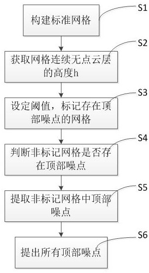
[0022] Such as figure 1 As shown, a LiDAR-based point cloud top noise removal method, the point cloud data is located in three-dimensional space coordinates, including the following steps:

[0023] S1: Establish a standard grid for the point cloud data on the XOY coordinate plane, set the grid side length parameter value, and obtain the height value H' of the lowest point in the Z-axis direction in each grid, that is, the Z of the lowest point coordinate value;

[0024] S2: After step S1, according to the spatial distribution characteristics of the point cloud data, obtain the height h of the continuous point-free cloud layer on the vertical height of each grid, and record the initial height value H of the continuous point-fre...