Method for borehole radar image rock stratum classification based on texture features

A technology of borehole radar and texture feature, which is applied in the field of rock layer classification, and the field of borehole radar image rock layer classification based on texture feature, can solve the problems of low detection and classification efficiency, error-prone manual detection, low degree of automation, etc., and achieves good practicability. , the effect of high degree of automation and high work efficiency

Inactive Publication Date: 2018-05-04
WUHAN UNIV
View PDF5 Cites 17 Cited by
  • Summary
  • Abstract
  • Description
  • Claims
  • Application Information

AI Technical Summary

Problems solved by technology

At present, the detection of rock structure is mainly through the inversion of the waveform and intensity characteristics of the reflected wave group in the geological radar image section, and the manual interpretation of the migration imaging. Although the demand is...

Method used


Image

  • Method for borehole radar image rock stratum classification based on texture features
  • Method for borehole radar image rock stratum classification based on texture features
  • Method for borehole radar image rock stratum classification based on texture features

Examples


Embodiment Construction

[0041] In order to describe the present invention more specifically, the technical solutions of the present invention will be described in detail below in conjunction with the accompanying drawings and specific embodiments.

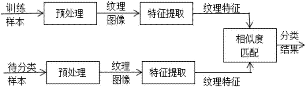
[0042] as attached figure 1 As shown, a method for classification of rock formations in borehole radar images based on texture features includes the following steps:

[0043] (1) Pre-collect the borehole radar image profiles of different rock formation types, manually distinguish these rock formation types, classify the rock formations into several typical categories, and let each category be I n , n=1,..., z, z is the total number of categories, select 50-100 sample image blocks of 16*16 pixels in each category to form a sample library;

[0044] (2) collecting the borehole radar image profile to be classified, and obtaining the image to be classified;

[0045] (3) Preprocessing the image to be classified: Gaussian filtering and binarization processing ...


PUM


Abstract

The invention discloses a method for borehole radar image rock stratum classification based on texture features. The method includes step (1) of establishing a sample library; step (2) of acquiring across-sectional image of a borehole radar image to be classified to obtain an image to be classified; step (3) of performing sample image feature extraction and training; step (4) of extracting features of the image to be classified; step (5) of performing rock stratum classification on image blocks to be classified: performing similarity matching according to an obtained texture feature matrix; classifying the image blocks to be classified into a category with the largest similarity, and outputting rock stratum classification results; and step (6) of repeating steps (4)-(5) until each image block of the image to be classified is classified, to achieve texture classification of the borehole radar image. According to the method, in the borehole radar image cross-sectional image, the texturefeatures in the image are directly extracted to describe the rock stratum structure, the signal processing process is simplified, and the judgment basis and effective conditions are provided for theautomatic identification and classification of the rock stratum structure.

Description

technical field [0001] The invention relates to a method for classifying rock strata, in particular to a method for classifying rock strata in borehole radar images based on texture features, and belongs to the technical field of rock mass engineering and image recognition. Background technique [0002] When carrying out geological engineering such as tunnel construction, bridge design, petroleum development, building quality inspection, and geological disaster prevention and control, it is often necessary to carry out geological exploration to understand the structure and shape of geological rock formations. The structural quality of the rock formation seriously affects the design and construction of the project, the construction period and the cost. Therefore, it is of great practical significance to automatically classify and identify rock mass structures with different morphological characteristics such as cracks, bedding, fractures, fracture zones, karst and groundwater...

Claims


Application Information

Patent Timeline
IPC IPC(8): G06K9/62G06K9/46G06K9/38G06K9/40
CPCG06V10/28G06V10/30G06V10/462G06F18/24
Inventor 李立余翠龙凡张春风
Owner WUHAN UNIV
Why Eureka
Try Eureka