
Method for extracting gap fraction of vegetation canopy by three-dimensional laser point cloud

A 3D laser, vegetation canopy technology, applied in permeability/surface area analysis, measurement device, suspension and porous material analysis, etc. Achieve the effect of avoiding distortion and accurate extraction

Active Publication Date: 2018-06-22
UNIV OF ELECTRONIC SCI & TECH OF CHINA
View PDF5 Cites 9 Cited by
  • Summary
  • Abstract
  • Description
  • Claims
  • Application Information

AI Technical Summary

Problems solved by technology

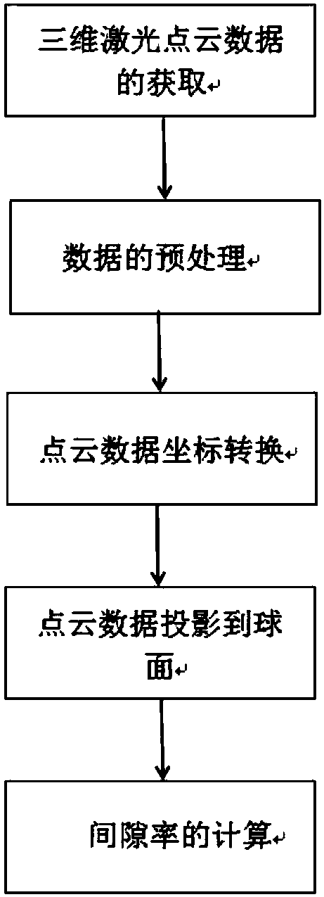
[0006] In view of the above-mentioned problems or deficiencies, in order to solve the problems in the prior art: digital hemispherical photography technology limited camera, light conditions, artificially set thresholds and building a 3D voxel model based on ground-based lidar point cloud data have poor correlation, large amount of calculation, Due to the time-consuming technical problem of the algorithm, the present invention provides a method for extracting the vegetation canopy gap rate from the three-dimensional laser point cloud, based on the ground-based laser radar

Method used


Image

  • Method for extracting gap fraction of vegetation canopy by three-dimensional laser point cloud
  • Method for extracting gap fraction of vegetation canopy by three-dimensional laser point cloud
  • Method for extracting gap fraction of vegetation canopy by three-dimensional laser point cloud

Examples


Embodiment Construction

[0028] The present invention is further explained by example below:

[0029] Step 1. First, set up Leica ScanStationC10 three-dimensional laser scanners at the center of the forest sample quadrat and the outside of the sample plot in the research area, and set up 6 targets to ensure that at least three identical targets can be scanned at every two sites, so as to The coordinate system of the central point of the square is the standard of the observation point. Combined with the Cyclone data processing software, the obtained multi-site cloud data is subjected to point cloud registration according to the target, and the sample square point cloud data is obtained after denoising. Then cut the 3D point cloud data of the forest quadrat into a circular quadrat with the center of the quadrat as the center and r as the radius (the value of r is determined according to the demand), and then all the points lower than the height of the 3D laser scanner Eliminate (z<0) to get the 3D point...


PUM


Abstract

The invention belongs to the technical field of laser radar remote sensing, and specifically relates to a method for extracting a gap fraction of a vegetation canopy by a three-dimensional laser pointcloud. The method provided by the invention comprises the following steps: acquiring three-dimensional point cloud data of a vegetation-like square canopy by a ground three-dimensional laser radar scanning system without influence of illumination conditions, a camera and manually set thresholds during observation; then, projecting the cloud data to a sphere and a hemisphere for region division bya point cloud data conversion coordinate system; and finally, calculating the gap fraction of the canopy. The method provided by the invention projects the point cloud data to a sphere surface for solving the gap fraction and guaranteeing correlation of results, avoids problems of distortion, the large amount of calculation and time-consuming algorithm when using a voxel model to represent a canopy structure, and can rapidly and accurately extract the gap fraction of the vegetation canopy.

Description

technical field [0001] The invention belongs to the technical field of laser radar remote sensing, and relates to a method for calculating forest canopy gap ratio by using point cloud data acquired by a ground three-dimensional laser scanner, specifically a method for extracting vegetation canopy gap ratio from three-dimensional laser point cloud. Background technique [0002] In the process of vegetation interacting with the external environment, the canopy is the most direct and active part. The vegetation canopy has a very important impact on the energy exchange of the ecosystem, atmospheric circulation, species diversity, climate regulation, etc. In the related field of canopy research, the research on the characteristic parameters of canopy structure is very common. The characteristic parameters of canopy structure not only help to understand the whole ecological process of vegetation, but also are important input parameters of many ecological models. Canopy gap ratio...

Claims


Application Information

Patent Timeline
IPC IPC(8): G01N15/08
CPCG01N15/088
Inventor 李世华林森
Owner UNIV OF ELECTRONIC SCI & TECH OF CHINA
Learn More