Geographic positioning system and method based on image recognition cloud service
A geolocation and image recognition technology, applied in measuring devices, instruments, surveying and navigation, etc., can solve the problems of huge data volume in the location database, GPS cannot be used for indoor positioning, and slow image matching speed, etc., to achieve strong adaptability and narrow down The effect of improving the search range and accuracy
- Summary
- Abstract
- Description
- Claims
- Application Information
AI Technical Summary
Problems solved by technology
Method used
Image

Examples
Embodiment 1
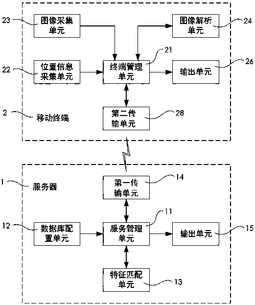
[0082] Embodiment 1: as image 3 As shown, in this embodiment, the geographic positioning system based on image recognition cloud service is composed of server 1 and mobile terminal 2; server 1 includes service management unit 11, database configuration unit 12, feature matching unit 13 and first transmission unit 14 The service management unit 11 is used to coordinate the work of the server 1, and it can contain a storage unit, i.e. a storage unit, for storing the database; the database configuration unit 12 is used to set up a temporary query database; the feature matching unit 13 is used to match the features of the scene image and query the image features in the database to seek optimal matching; the first transmission unit 14 communicates with the mobile terminal 2, and the communication mode can be a 3G\4G network or a wifi network; the mobile terminal 2 includes a terminal management unit 21, a location information collection unit 22. Image acquisition unit 23, image an...
Embodiment 2
[0089] Embodiment 2: as Figure 4 As shown, in this embodiment, the difference from Embodiment 1 is that the image analysis unit 16 is set on the server 1, and the image collected by the image acquisition unit 23 is directly sent to the server 1 by the mobile terminal 2, and the server 1 integrates the The image analysis unit 16 on it extracts image features from the image; this embodiment can reduce the hardware requirements for the mobile terminal 2; specifically, the geographic positioning system based on image recognition cloud service is composed of a server 1 and a mobile terminal 2; The server 1 includes a service management unit 11, a database configuration unit 12, a feature matching unit 13, an image analysis unit 16 and a first transmission unit 14; the service management unit 11 is used to coordinate the work of the server 1, and it may contain a storage unit, i.e. a storage unit, For storing the database; the database configuration unit 12 is used to set up a temp...
Embodiment 3
[0096] Embodiment 3: as Figure 5 Shown is the structural diagram of the mobile terminal of Embodiment 3. In this embodiment, the difference from Embodiment 1 and Embodiment 2 is that the mobile terminal 2 is provided with a database configuration unit 27 and a feature matching unit 25. In the case of a wireless network or in the absence of a network, first download the area data in the data configuration unit of the server to the storage unit of the mobile terminal under the environment of the network, as the data configuration unit of the mobile terminal; 2 The small-scale database is downloaded by the database configuration unit 27, and the mobile terminal 2 can directly complete the steps of feature matching and display position information display through the feature matching unit 25. The mobile terminal 2 can collect the image by the mobile terminal 2 through the downloaded offline data package. The image data acquired by the unit 23 is processed into feature description...
PUM
 Abstract
Description
Claims
Application Information
 - Generate Ideas
- Intellectual Property
- Life Sciences
- Materials
- Tech Scout
- Unparalleled Data Quality
- Higher Quality Content
- 60% Fewer Hallucinations
Browse by: Latest US Patents, China's latest patents, Technical Efficacy Thesaurus, Application Domain, Technology Topic, Popular Technical Reports.
© 2025 PatSnap. All rights reserved.Legal|Privacy policy|Modern Slavery Act Transparency Statement|Sitemap|About US| Contact US: help@patsnap.com