Hierarchical distributed autonomous collaborative task planning system for intelligent remote sensing satellite

A technology for remote sensing satellites and mission planning, which is applied in the field of remote sensing satellites and can solve the problems of satellite mission planning, system engineering difficulty, complexity of mission sample selection, and difficulty in increasing schedulability prediction.

Inactive Publication Date: 2018-07-27
FOSHAN UNIVERSITY +1
View PDF3 Cites 26 Cited by
  • Summary
  • Abstract
  • Description
  • Claims
  • Application Information

AI Technical Summary

Problems solved by technology

[0004] (1) The complexity of the task planning problem
Intelligent satellite mission planning has certain particularities in four aspects: tasks, resources, constraints, and optimization objectives, and common resource scheduling models and optimization methods are difficult to solve
[0005] (2) The complexity and uncertainty of the scheduling algorithm
The randomness of the scheduling algorithm makes the scheduling results uncertain, and also increases the difficulty of schedulability prediction
[0006] (3) Complexity of task sample selection
[0007] (4) The complexity of sample feature extraction
How to select the features that have a decisive impact on the prediction process among various attributes is also very complicated
[0008] (5) The daily imaging observation requirements submitted by

Method used


Image

  • Hierarchical distributed autonomous collaborative task planning system for intelligent remote sensing satellite
  • Hierarchical distributed autonomous collaborative task planning system for intelligent remote sensing satellite
  • Hierarchical distributed autonomous collaborative task planning system for intelligent remote sensing satellite

Examples


Embodiment Construction

[0066] In order to make the purpose, technical solutions and advantages of the present invention more clear, the present invention will be further described in detail below in conjunction with specific examples. It should be understood that these descriptions are exemplary only, and are not intended to limit the scope of the present invention. Also, in the following description, descriptions of well-known structures and techniques are omitted to avoid unnecessarily obscuring the concept of the present invention.

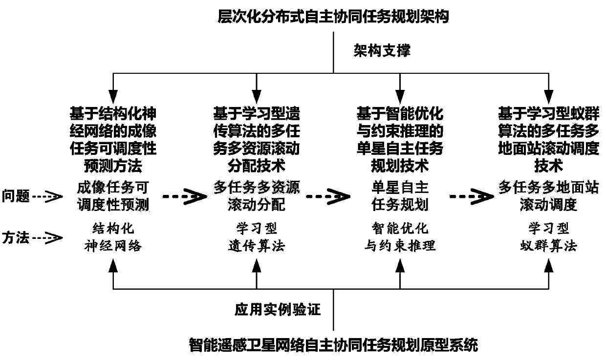
[0067] The intelligent remote sensing satellite hierarchical distributed autonomous collaborative task planning system of the present invention includes a multi-satellite task coordinator and an on-board scheduler, and the multi-satellite task coordinator assigns the tasks in the task set to be assigned to multiple intelligent satellites under its jurisdiction. The satellites process the tasks into meta-tasks directly recognized by the on-board scheduler, and each in...


PUM


Abstract

The invention discloses a hierarchical distributed autonomous collaborative task planning system for an intelligent remote sensing satellite. The system comprises a multi-satellite task coordinator and an on-satellite scheduler, wherein the multi-satellite task coordinator distributes tasks in a task set to be distributed to multiple affiliated intelligent satellites and processes the tasks into meta-tasks which can be directly identified by the on-satellite scheduler; each intelligent satellite utilizes the on-satellite scheduler to carry out uniform scheduling on a new distributed task and an existing task; and before the multi-satellite task coordinator carries out task distribution, a scheduling result on the relevant on-satellite scheduler is estimated in advance and is taken as a basis for task distribution. Key scientific problems and technical problems of imaging task schedulability prediction, multi-task multi-resource dynamic scheduling under a high-dimensional space, refinedplanning and scheduling algorithm design are successfully tackled, a multi-satellite autonomous collaborative task planning technology can be better applied to the field of national defense construction, and the rationalization of a distribution scheme and the high efficiency of resource utilization can be accelerated.

Description

technical field [0001] The invention relates to the technical field of remote sensing satellites, in particular to a hierarchical distributed autonomous collaborative task planning system for intelligent remote sensing satellites. Background technique [0002] Remote sensing satellites are artificial satellites used as remote sensing platforms in outer space. Typically, remote sensing satellites remain in orbit for several years. Satellite orbits can be determined as needed. Remote sensing satellites can cover the entire earth or any designated area within a specified period of time. When running along a geosynchronous orbit, they can continuously remote sense a designated area on the earth's surface. All remote sensing satellites need remote sensing satellite ground stations. The satellite data obtained from the remote sensing market platform can monitor agriculture, forestry, ocean, land, environmental protection, meteorology, etc. Remote sensing satellites mainly includ...

Claims


Application Information

Patent Timeline
IPC IPC(8): G06Q10/06
CPCG06Q10/0631
Inventor 邢立宁何敏藩白国庆吕欣王炯琦伍国华陈剑黄勇熊彦文翰
Owner FOSHAN UNIVERSITY
Why Eureka
Try Eureka