Method for estimating leaf area index (LAI) of patch scale winter wheat based remote sensing satellite data

A technology of leaf area index and remote sensing satellite, which is applied in image data processing, calculation, measuring devices, etc., and can solve problems that are rarely discussed

Active Publication Date: 2018-10-16
ZHEJIANG UNIV
View PDF5 Cites 21 Cited by
  • Summary
  • Abstract
  • Description
  • Claims
  • Application Information

AI Technical Summary

Problems solved by technology

[0005] At present, the inversion method of winter wheat LAI using medium and low-resolution remote sensing images is relatively mature. However, how to invert LAI at the block scale is seldom discussed.
In the

Method used


Image

  • Method for estimating leaf area index (LAI) of patch scale winter wheat based remote sensing satellite data
  • Method for estimating leaf area index (LAI) of patch scale winter wheat based remote sensing satellite data
  • Method for estimating leaf area index (LAI) of patch scale winter wheat based remote sensing satellite data

Examples


Embodiment Construction

[0028] The present invention will be further described below in conjunction with the accompanying drawings and implementation examples.

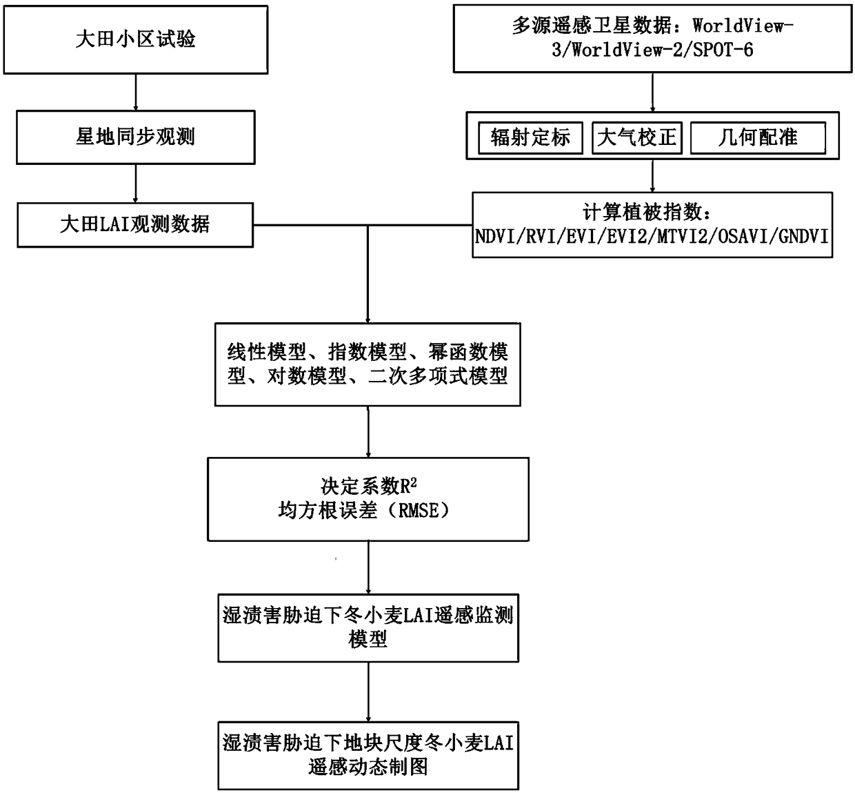
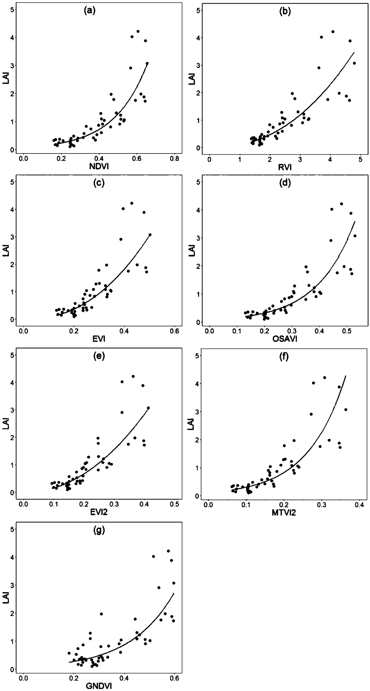
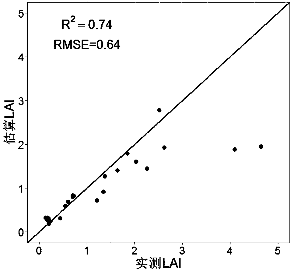
[0029] Such as figure 1As shown, it is a flow chart of the method for estimating the leaf area index of winter wheat at the plot scale based on remote sensing satellite data in the present invention. Specifically, firstly, high spatial resolution remote sensing images covering the research area are purchased. The acquisition of the remote sensing images involved in the present invention is to sign a contract with the company for programming reception, but due to the influence of the weather (such as clouds and rain) in the research area, the available images cannot be obtained when the satellite runs over the research area. Therefore, high spatial resolution imagery from other satellites was purchased. Field leaf area index observations are made when satellites are in transit and high spatial resolution data are available. After the remote...


PUM


Abstract

The invention discloses a method for estimating the leaf area index (LAI) of patch scale winter wheat based on high-spatial-resolution remote sensing satellite imagery, comprising: step 1, obtaining LAI data of a sampling point in a key growth period of winter wheat before heading; step2, obtaining a high-spatial-resolution remote sensing image covering a winter wheat field experimental research area, performing processing, and obtaining a vegetation index corresponding to the sampling point in step 1 through the band calculation; step 3, partially applying the LAI data and the vegetation index to construct models, and using the rest as verification data; step 4, verifying the constructed models with the verification data, obtaining decision coefficients R2 and root mean square errors of the model, and selecting a model of the maximum decision coefficient R2 and the minimal root mean square error as the optimal model; and step 6, applying the obtained optimal model to estimation of theleaf area index of the patch scale winter wheat.

Description

technical field [0001] The invention relates to the technical field of winter wheat leaf area index estimation, in particular to a method for estimating winter wheat leaf area index at the block scale based on remote sensing satellite data. Background technique [0002] Accurate estimation of canopy biophysical parameters during crop growth and development is of great significance for optimizing crop field management measures. As a commonly used indicator of crop canopy, leaf area index (LAI) is often used to monitor the development and changes of crop canopy structure and estimate crop yield. Accurate estimation of LAI can provide theoretical support for crop fertilization, irrigation, pest control, and grain productivity. The traditional fixed-point observation in Daejeon is not only time-consuming and laborious, but also can only obtain the LAI value of a single point, and cannot obtain the LAI of the surface. With the development of remote sensing technology, large-sca...

Claims


Application Information

Patent Timeline
IPC IPC(8): G01B11/28G06T5/00
CPCG01B11/285G06T5/006
Inventor 刘围围黄敬峰
Owner ZHEJIANG UNIV
Why Eureka
Try Eureka