Cloud computing-based public place image information acquisition unmanned aerial vehicle control system

A technology for public places, image information, applied in computer parts, computing, instruments, etc., can solve problems such as reducing the time performance of the method

Inactive Publication Date: 2018-11-02
HENAN UNIV OF ANIMAL HUSBANDRY & ECONOMY
View PDF5 Cites 3 Cited by
  • Summary
  • Abstract
  • Description
  • Claims
  • Application Information

AI Technical Summary

Problems solved by technology

When directly texture mapping a surface represented by a large number of grids, the texture coo

Method used


Image

  • Cloud computing-based public place image information acquisition unmanned aerial vehicle control system
  • Cloud computing-based public place image information acquisition unmanned aerial vehicle control system
  • Cloud computing-based public place image information acquisition unmanned aerial vehicle control system

Examples


Embodiment Construction

[0110] In order to further understand the content, features and effects of the present invention, the following examples are given, and detailed descriptions are given below with reference to the accompanying drawings.

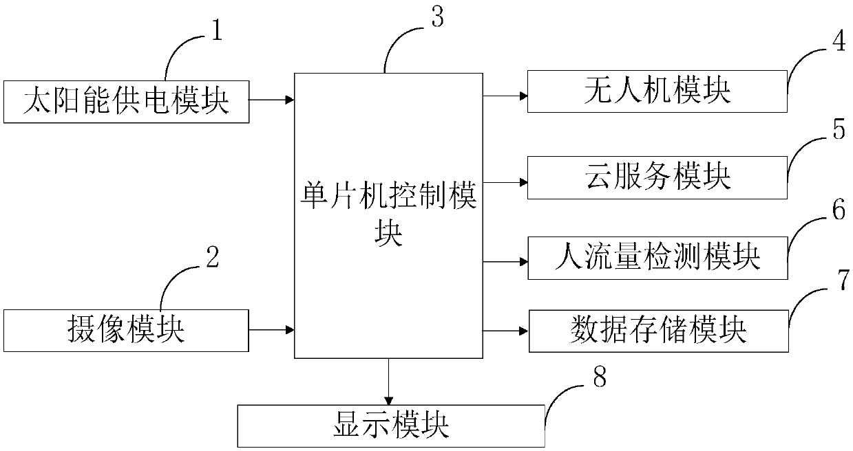
[0111] like figure 1 As shown, the cloud computing-based public place image information collection drone control system provided by the embodiment of the present invention includes: solar power supply module 1, camera module 2, single-chip microcomputer control module 3, drone module 4, cloud service module 5 , People flow detection module 6, data storage module 7, display module 8.

[0112] The solar power supply module 1 is connected with the single-chip microcomputer control module 3, and is used to convert solar energy into electric energy through the solar panel for power supply;

[0113] The camera module 2 is connected with the single-chip microcomputer control module 3, and is used to collect images in public places through the camera;

[0114] The ...


PUM


Abstract

The invention belongs to the technical field of image acquisition and discloses a cloud computing-based public place image information acquisition unmanned aerial vehicle control system. The system comprises a solar power supply module, a camera module, a single-chip microcomputer control module, an unmanned aerial vehicle module, a cloud service module, a people flow detection module, a data storage module and a display module, wherein the people flow detection module is connected with the single-chip microcomputer control module, and is used for detecting people flow data information by processing and analyzing collected images; and the people flow detection module is integrated with a people flow image construction module. According to the system, efficient and clean solar energy can beacquired through the solar power supply module, and an unmanned aerial vehicle can be powered permanently, so that the working duration of the unmanned aerial vehicle is prolonged, and the image collection efficiency is improved; and meanwhile, through the cloud service module and the people flow detection module, the image processing speed can be greatly improved, and the people flow detection speed and precision can be improved.

Description

technical field [0001] The invention belongs to the technical field of image acquisition, and in particular relates to a cloud computing-based UAV control system for image information acquisition in public places. Background technique [0002] At present, the existing technologies commonly used in the industry are as follows: [0003] Public places refer to occasions where people often gather, are used by the public, or serve the people. It is generally manifested as a place with more than two people. For example, school classrooms, school dormitories, etc. School dormitories generally have 4 to 6 people, and should also be regarded as public places. However, the existing UAVs for image collection in public places have short working hours, poor battery life, and low image collection efficiency; at the same time, the existing detection speed of people flow in public places is slow and the accuracy is not high, which usually cannot effectively solve the problem of people. ...

Claims


Application Information

Patent Timeline
IPC IPC(8): G06K9/00G06K9/62
CPCG06V20/42G06V20/53G06F18/2411
Inventor 吴慧玲马金素贺广生
Owner HENAN UNIV OF ANIMAL HUSBANDRY & ECONOMY
Why Eureka
Try Eureka