Positioning method and device based on inertial navigation and satellite navigation

A positioning method and satellite navigation technology, which are applied in the field of positioning methods and devices based on inertial navigation and satellite navigation, can solve the problems of large influence of GNSS signal environment and satellite signals affecting positioning results, etc., so as to improve the frequency of output and suppress direction drift. and error accumulation to ensure the effect of short-term accuracy

Active Publication Date: 2018-11-27
湖南云箭格纳微信息科技有限公司
View PDF12 Cites 12 Cited by
  • Summary
  • Abstract
  • Description
  • Claims
  • Application Information

AI Technical Summary

Problems solved by technology

[0005] The problem to be solved by the present invention is to provide a positioning method and device based on inertial navigation and satellite navigation

Method used


Image

  • Positioning method and device based on inertial navigation and satellite navigation
  • Positioning method and device based on inertial navigation and satellite navigation
  • Positioning method and device based on inertial navigation and satellite navigation

Examples


Example Embodiment

[0070] The technical solutions in the embodiments of the present application will be clearly and completely described below in conjunction with the drawings of the present application. Obviously, the described embodiments are only a part of the embodiments of the present application, rather than all the embodiments. Based on the embodiments in this application, all other embodiments obtained by those of ordinary skill in the art without creative work fall within the protection scope of this application.

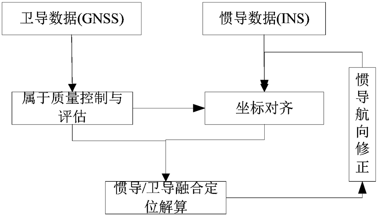
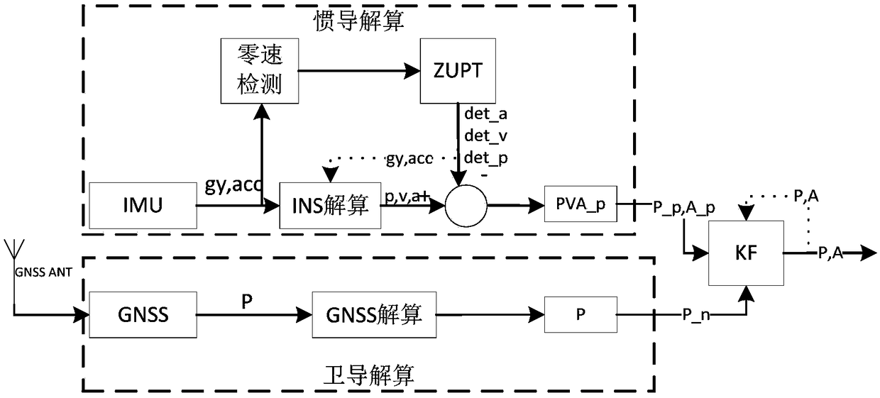
[0071] Such as figure 1 — Figure 7 As shown, the present invention provides a positioning method and device based on inertial navigation and satellite navigation.

[0072] The micro-inertial navigation / satellite navigation (INS / GNSS) global personnel positioning system provided by the present invention is a precise positioning system that seamlessly connects indoors and outdoors. The realization of the present invention mainly includes:

[0073] (1) GNSS-assisted MEMS rapid and ac...


PUM


Abstract

The invention provides a positioning method and device based on inertial navigation and satellite navigation. The method includes the steps: (1) calculating a first included angle, horizontal axis translation amount and vertical axis translation amount; (2) constructing a system state matrix by the aid of estimation values of a coordinate and a course angle of a user under a horizontal free azimuth coordinate system, constructing a system parameter matrix by the aid of the step length and the estimation values of the course angle of the user under the horizontal free azimuth coordinate system,constructing a measurement value matrix by the aid of a first coordinate and a first course angle, constructing a state equation and a measurement equation of an extended Kalman filter, and calculating an estimation value of a user coordinate by an extended Kalman filter method. According to the positioning method, the satellite navigation and micro-inertial navigation are combined, high-accuracypositioning under long-time complex scenes is achieved by the aid of the advantages of satellite navigation and inertial navigation, satellite navigation has the advantages that the accuracy is high,and errors are stable and cannot be accumulated along with time, inertial navigation has the advantages of high short-term accuracy, and indoor accurate positioning and outdoor accurate positioning can be seamlessly connected.

Description

technical field [0001] The invention relates to a positioning method and device, in particular to a positioning method and device based on inertial navigation and satellite navigation. Background technique [0002] As the value of urban land increases, the buildings in the city are built higher and higher, and the variety of apartment types makes the internal structure more and more complicated. When a fire or other accident occurs, how to rescue the trapped people at the first time is very important. , which puts forward very high requirements for on-site command and dispatch, and to achieve efficient command, it is necessary to know the current position of each rescued person and rescuer at all times. However, the fire scene is full of smoke and dust, the lighting equipment fails, the visibility is low, and the accuracy of identifying the position by itself is greatly reduced. Therefore, the individual positioning system provides good technical support. With the help of th...

Claims


Application Information

Patent Timeline
IPC IPC(8): G01C21/16G01C21/20G01S19/47
CPCG01C21/165G01C21/20G01S19/47
Inventor 闵涛满小三罗小勇杨丛昊
Owner 湖南云箭格纳微信息科技有限公司
Why Eureka
Try Eureka