Unmanned aerial vehicle indoor positioning system and method with obstacle avoidance function

An indoor positioning and drone technology, applied in control/adjustment systems, three-dimensional position/channel control, vehicle position/route/altitude control, etc., can solve the problem of being unsuitable for indoor flight, high cost, and lack of positional information to rely on features and other problems, to achieve the effect of precise flight control, high-precision and accurate positioning, and cost reduction.

Pending Publication Date: 2018-11-30
STATE GRID SHANDONG ELECTRIC POWER +1
View PDF9 Cites 18 Cited by
  • Summary
  • Abstract
  • Description
  • Claims
  • Application Information

AI Technical Summary

Problems solved by technology

It uses ultra-wideband pulse signals, and uses preset sensors to track and analyze signal tags. It has strong multipath resolution and high precision. However, this type of positioning system needs to arrange sensors for positioning indoors, which is costly and limited in positioning range. poor portability
[0007] The fifth type: laser Lidar technology, due to the use of laser scanning, the positioning accuracy is high and the reliability is high, but the price is expensive. The 64-line 3D scanning laser radar is generally around 600,000 RMB, which is dozens of times that of the above four solutions Even hundreds of times the price, and the equipment itself is heavy and bulky, requiring a larger drone to carry it, which is not suitable for indoor flying
[0010] 1. Lack of reliable features that can be used to accurately judge location information
[0011] 2. Lack of methods that can be used to accurately estimate location information and track location changes
[0012] 3. Lack of real-time acquisition of indoor obstacle information

Method used


Image

  • Unmanned aerial vehicle indoor positioning system and method with obstacle avoidance function
  • Unmanned aerial vehicle indoor positioning system and method with obstacle avoidance function
  • Unmanned aerial vehicle indoor positioning system and method with obstacle avoidance function

Examples


Embodiment 1

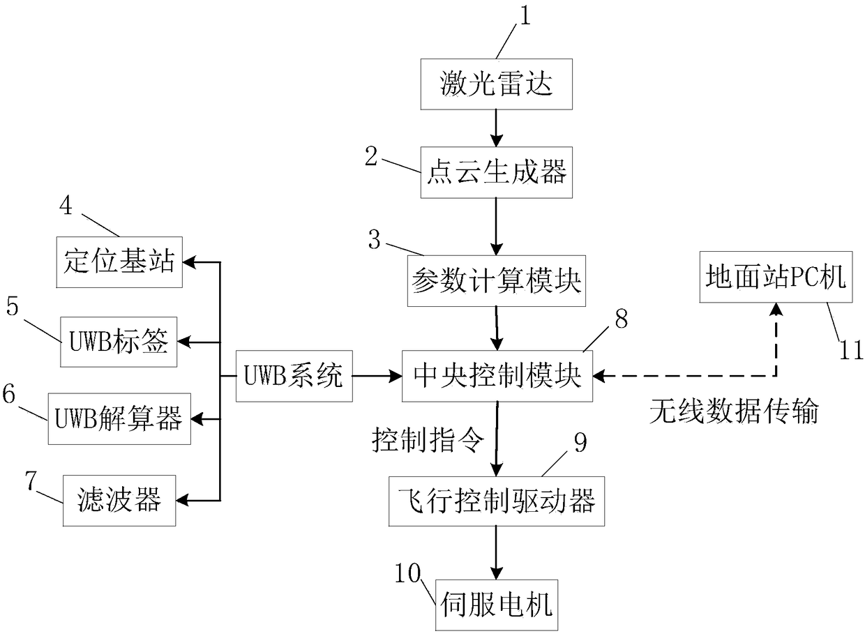
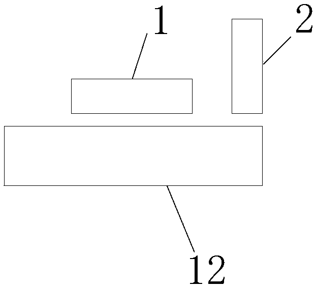
[0045] The UAV indoor positioning system with obstacle avoidance function described in the present invention, such as figure 1 As shown, it includes a laser radar 1 system, a UWB system, a central control module 8, a flight control driver 9, a servo motor 10, and a ground station PC 11; the laser radar 1 system and the UWB system are respectively connected to the central control module 8, and the central control module 8. The flight control driver 9 and the servo motor 10 are connected in sequence, and the ground station PC 11 is connected with the central control module 8 through a wireless communication module and performs data transmission for real-time monitoring of the unmanned aerial vehicle 12; the central control module 8 is used to receive Signals from the laser radar 1 system and the UWB system, and send control instructions to the flight control driver 9, and the flight control driver 9 sends a drive signal to the servo motor 10 to drive the drone to fly.

[0046] T...

Embodiment 2

[0049] The present invention also provides an indoor positioning method for unmanned aerial vehicle with obstacle avoidance function, which is characterized in that: comprising the following steps:

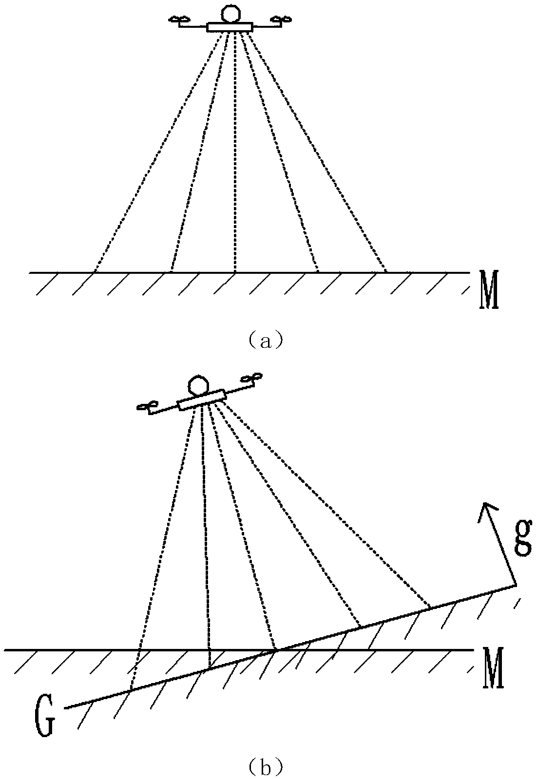
[0050] Step 1: Use the laser radar 1 installed on the UAV to collect indoor 3D point cloud images in real time according to the set acquisition frequency, and detect the plane of the 3D point cloud image and the distance between the plane and the location of the UAV to obtain the UAV The distance between the current position and the obstacle;

[0051] Step 2: Obtain the distance values ​​from the UWB tag 5 on the drone to each positioning base station 4 in the room in real time;

[0052] Step 3: Correct the distance value obtained from the UWB tag 5 according to the correction function fitted by the actual measurement results;

[0053] Use a UWB tag 5, fix it in an open position, move the drone to a distance of 41m from the positioning base station, record the distance value Y1 o...


PUM


Abstract

The invention relates to an unmanned aerial vehicle indoor positioning system and method with an obstacle avoidance function, and belongs to the technical field of unmanned aerial vehicle positioning.According to the unmanned aerial vehicle indoor positioning system and method with the obstacle avoidance function, an indoor 3D point cloud image is collected in real time through a laser radar system, and a plane of the 3D point cloud image and the distance between the plane and the position of the unmanned aerial vehicle are detected to obtain the distance between the current position of the unmanned aerial vehicle and an obstacle; the distance from an UWB tag on the unmanned aerial vehicle to a positioning base station is acquired in real time through a UWB system, the coordinates of theUWB tag on the unmanned aerial vehicle are calculated and corrected, and the horizontal translation amount of the target position of the unmanned aerial vehicle and the current position of the unmanned aerial vehicle is calculated; and a central control module is used for receiving signals of the laser radar system and the UWB system and sending out control instructions to control the precise flight of the unmanned aerial vehicle.

Description

technical field [0001] The invention relates to an indoor positioning system and method for an unmanned aerial vehicle with an obstacle avoidance function, and belongs to the technical field of unmanned aerial vehicle positioning. Background technique [0002] Due to the advancement of the scientific level, the fields involved in unmanned aerial vehicles are becoming wider and wider, and they have very broad application prospects in both military and civilian fields. The first step in UAV research is to locate and navigate it. In order to solve the problem of indoor positioning, various scientific research institutions and entrepreneurial companies have carried out a lot of research on indoor positioning, aiming to find an effective indoor positioning solution. At present, the UAV positioning researched at home and abroad mainly includes: [0003] The first type: a satellite positioning system based on GPS or Beidou. However, it is used for outdoor positioning, and it is ...

Claims


Application Information

Patent Timeline
Patent Type & Authority Applications(China)
IPC IPC(8): G05D1/10
CPCG05D1/101
Inventor 周君路朝阳安树怀王奉冲于强吴石书刘学松肖文军林柏桦
Owner STATE GRID SHANDONG ELECTRIC POWER
Why Eureka
Try Eureka