All-terrain all-source combined navigation system for intelligent agricultural machinery

An integrated navigation system and all-terrain technology, which is applied in the field of integrated navigation of agricultural machinery, can solve the problems of wrong navigation results, long initialization time, and GPS signals are easily blocked, so as to improve accuracy and intelligence, and avoid operation failure.

Inactive Publication Date: 2019-01-01
JIANGSU UNIV
View PDF9 Cites 11 Cited by
  • Summary
  • Abstract
  • Description
  • Claims
  • Application Information

AI Technical Summary

Problems solved by technology

Traditional integrated navigation products are difficult to apply to the field of agricultural machinery due to factors such as weather, terrain, and accuracy
At present, this combination mode has been applied in the case of unobstructed fields, but in mountainous hills and densely planted orchards, due to vegetation and terrain, GPS signals are easily blocked, and there are navigation blind spots, resulting in errors in navigation results.
Moreover, traditional high-precision inertial navigation products have problems such as long initialization time, filtering methods that need to be improved, jumps in the actual use process, and not suitable for long-term navigation. The single navigation mode is difficult to meet the requirements of my country's current intelligent agriculture.
[0003] At present, my country's agricultural machinery is difficult to adapt to all-terrain requirements

Method used


Image

  • All-terrain all-source combined navigation system for intelligent agricultural machinery
  • All-terrain all-source combined navigation system for intelligent agricultural machinery
  • All-terrain all-source combined navigation system for intelligent agricultural machinery

Examples


Embodiment Construction

[0026] The present invention will be described in further detail below in conjunction with accompanying drawings and examples.

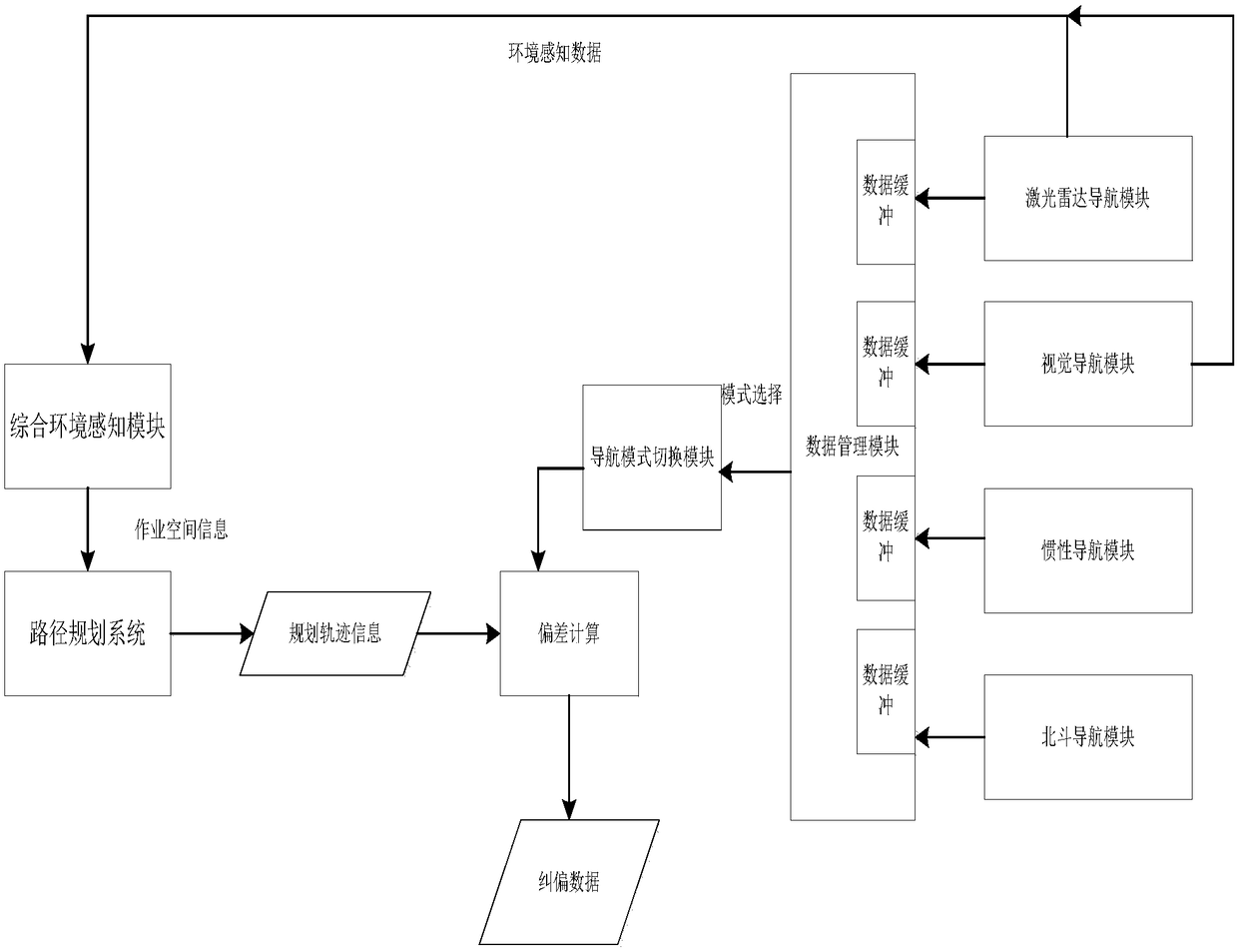
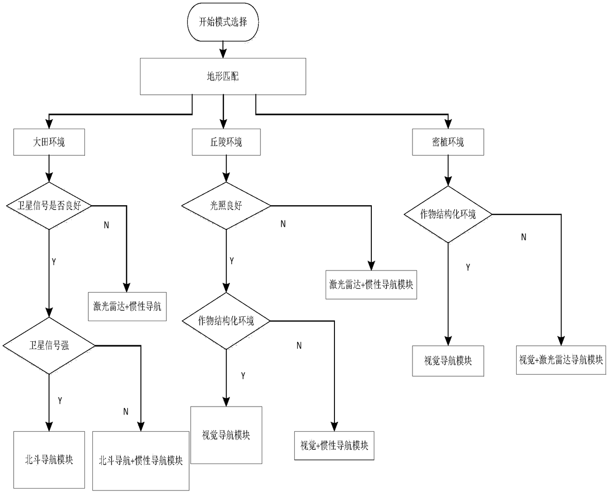
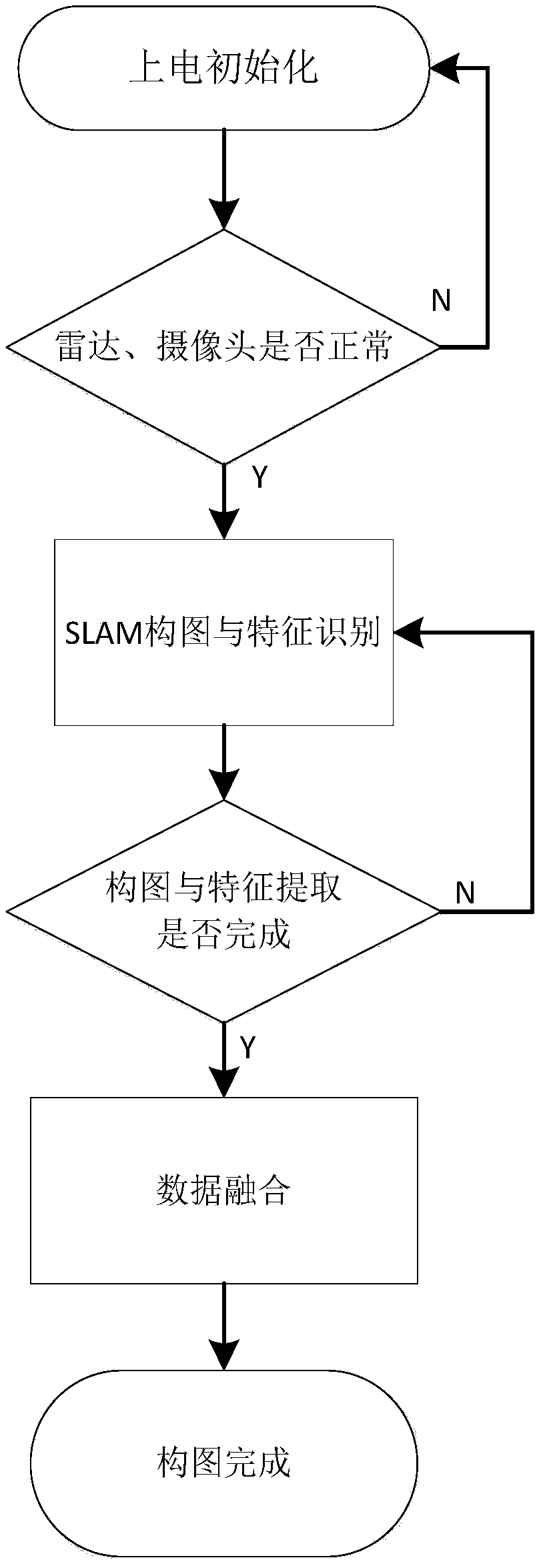
[0027] The navigation system in the present invention mainly includes a laser radar navigation module, a Beidou satellite navigation module, an inertial navigation module, a visual navigation module, a data management module, a data transmission module, an integrated environment perception module, a path planning module, and a navigation mode switching module.

[0028] The Beidou satellite navigation and positioning accuracy is high, but the signal is easily blocked in field operations, and there are navigation blind spots. In terms of equipment selection, this system selects the single-point positioning module of Beidou Satellite Communications, including: satellite antenna, receiver, and the single-point positioning accuracy reaches centimeter level. The problem of blind spots in satellite navigation is usually solved by integrated navigation. The...


PUM


Abstract

The invention discloses an all-terrain all-source combined navigation system for intelligent agricultural machinery and relates to the field of agricultural machinery operation. The all-terrain all-source combined navigation system comprises a laser radar navigation module, a Beidou satellite navigation module, an inertia navigation module, a visual navigation module, a route planning system, a data management module, a comprehensive environment sensing module and a navigation mode switching module, wherein the comprehensive environment sensing module can obtain environment data provided by alaser radar navigation system and a visual navigation system to construct a high-accuracy electronic map and can perform terrain match with navigation data; the data management module specifically comprises a data processing unit, a data synchronizing unit, a data sending unit and a data fusing unit and can provide high-accuracy and high-quality navigation data superior to a single sensor; the navigation mode switching module is mainly formed by a light intensity sensor, a satellite signal detection sensor, operation environment data and the like and can provide reference for navigation mode switching decision.

Description

technical field [0001] The invention belongs to the technical field of agricultural machinery integrated navigation, and in particular relates to an all-terrain and all-source integrated navigation system for intelligent agricultural machinery. Background technique [0002] At present, agricultural machinery navigation has problems such as single navigation mode and difficulty in adapting to all terrains. At present, most of my country's intelligent agricultural machinery adopts the combination mode of IMU and GPS. Traditional integrated navigation products are difficult to apply to the field of agricultural machinery due to factors such as weather, terrain, and accuracy. At present, this combination mode has been applied in unobstructed field conditions, but in mountainous hills and densely planted orchards, due to vegetation crops and terrain, GPS signals are easily blocked, and there are navigation blind spots, resulting in errors in navigation results. Moreover, tradit...

Claims


Application Information

Patent Timeline
Patent Type & Authority Applications(China)
IPC IPC(8): G01C21/20G01C21/18G01C21/16G01C21/06G01C21/08
CPCG01C21/005G01C21/06G01C21/08G01C21/165G01C21/18G01C21/20
Inventor 魏新华吉鑫崔冰波
Owner JIANGSU UNIV
Why Eureka
Try Eureka