Error compensation system and method for long-distance underground pipeline positioning system

A technology for underground pipelines and positioning systems, which is used in navigation, measuring devices, instruments, etc. through speed/acceleration measurement, and can solve problems such as inconvenient operation and difficulty in meeting accuracy requirements

Inactive Publication Date: 2019-01-04
CHINA JILIANG UNIV
View PDF0 Cites 3 Cited by
  • Summary
  • Abstract
  • Description
  • Claims
  • Application Information

AI Technical Summary

Problems solved by technology

However, the above detection technologies have their corresponding limitations: for pipelines buried below 5 meters or passing through rivers and lakes, it is difficult to meet the accuracy requirements of electromagnetic induction de...

Method used


Image

  • Error compensation system and method for long-distance underground pipeline positioning system
  • Error compensation system and method for long-distance underground pipeline positioning system
  • Error compensation system and method for long-distance underground pipeline positioning system

Examples


Embodiment Construction

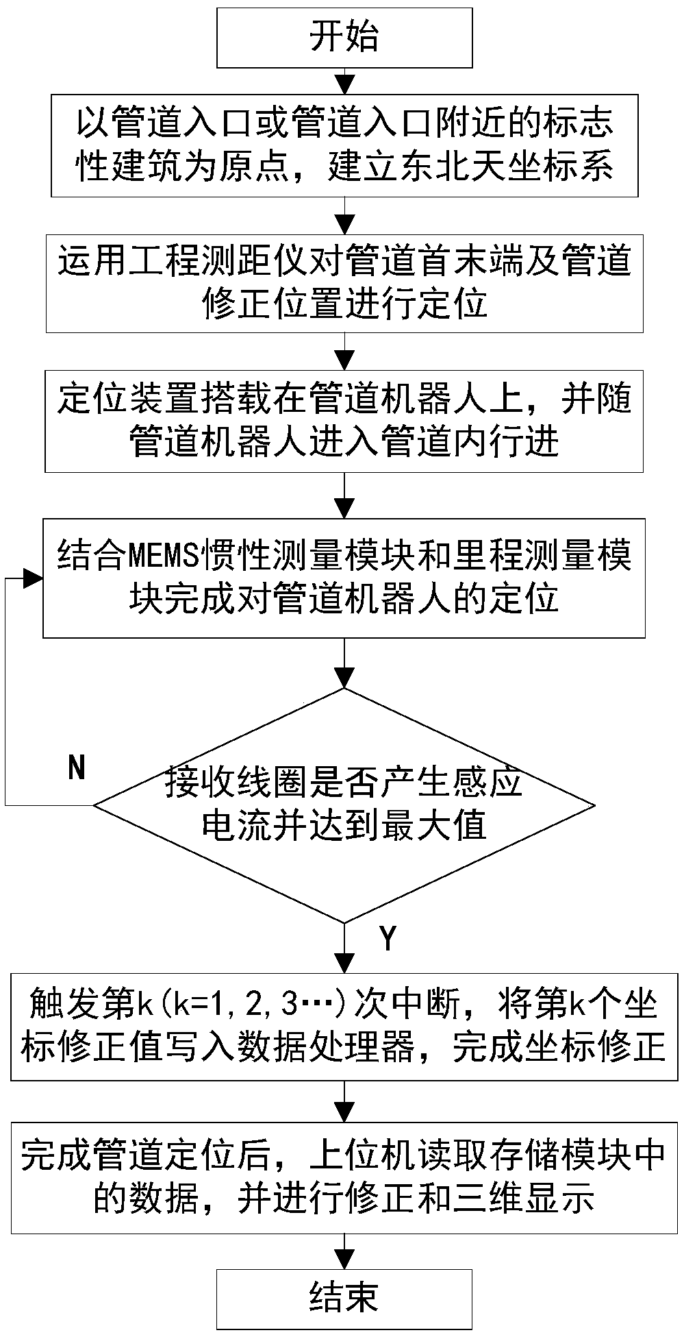
[0076] Such as figure 1 As shown, a preferred embodiment of the present invention provides an error compensation method for the positioning of long-distance underground pipelines. The specific steps of the method are as follows:

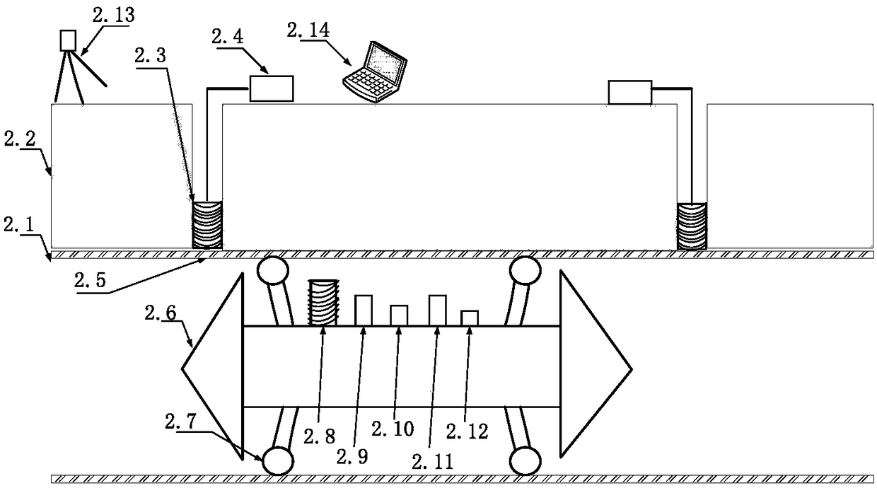
[0077] Step 1. Establish a three-dimensional ground coordinate system O-XYZ with the pipeline entrance or a landmark building near the pipeline entrance as the coordinate origin;

[0078] Step 2. Determine the three-dimensional coordinates of the beginning and end of the pipeline using the engineering range finder. According to the pre-mastered pipeline position information, drill down to the surface of the pipeline perpendicular to the O-XY plane, set the coordinate correction circuit outside the pipeline and measure the vertical depth of the pipeline center at this point, and then use the engineering distance meter to determine the coordinates Correct the three-dimensional coordinates of the points and the beginning and end of the pipeline, and wr...


PUM


Abstract

The invention discloses an implementation system of an error compensation method for a long-distance underground pipeline positioning system. The implementation system comprises a pipeline positioningdevice, an engineering distance measurement instrument and an upper computer; the pipeline positioning device is fixed to a pipeline robot and used for detecting the altitude angle and mileage data of the pipeline robot, and the position of the pipeline robot in a pipeline to be measured is worked out based on an inertial navigation principle; the pipeline positioning device travels in the pipeline along with the pipeline robot, and when an electromagnetic wave signal is received and reaches the highest strength, coordinate data for correcting a current position is triggered; the pipeline positioning device stores all pipeline coordinate data into a storage module; the engineering distance measurement instrument is set to be used for detecting the position coordinates of the head and tailends of the pipeline to be measured and plane coordinates of a pipeline exterior coordinate correcting point; the upper computer is set to be used for reading the coordinate data in the storage module, correcting inertial navigation positioning data, and finally conducting three-dimensional display on corrected pipeline coordinate data. The implementation system is large in application range andhigh in calculation precision.

Description

technical field [0001] The invention relates to the field of pipeline surveying and mapping, in particular to an error compensation method and an implementation system for a long-distance underground pipeline positioning system. Background technique [0002] Pipeline transportation is one of the five major transportation industries along with railways, highways, water transportation and shipping. It has the advantages of large transportation volume, not limited by climate and other factors on the ground, continuous operation and low cost. [0003] The normal operation of pipeline transportation is a major issue related to the safety of people's livelihood and the development of the national economy. When underground pipelines are destroyed, it may cause huge economic losses, and even cause major environmental pollution and casualties. When the location of the underground pipeline is not clear, it will bring a lot of inconvenience to the underground construction. In order t...

Claims


Application Information

Patent Timeline
IPC IPC(8): G01C21/16G01C25/00
CPCG01C21/16G01C25/005
Inventor 黎建军许晓东杨彩霞
Owner CHINA JILIANG UNIV
Why Eureka
Try Eureka