An ultra-long-distance UAV navigation method

An ultra-long-distance, navigation-based technology, applied in navigation, surveying and navigation, navigation computing tools, etc., can solve the problems of unmanned aerial vehicles that are difficult to control, accident-prone, and unfamiliar with the environment, and achieve expansion capabilities and resistance Strong failure capability, avoid the influence of bad weather, flexible and convenient to use

Active Publication Date: 2020-05-05
浙江翔龙航空科技有限公司
View PDF5 Cites 0 Cited by
  • Summary
  • Abstract
  • Description
  • Claims
  • Application Information

AI Technical Summary

Problems solved by technology

Existing drone navigation methods are not suitable for ultra-long-distance navigation. At ultra-long distances, it is difficult to control the accuracy of the position of the drone. Moreover, due to the long distance of the drone, if bad weather occurs, it is difficult to timely Retraction is prone to accidents and economic losses. At the same time, when the distance is too long, the environment is unfamiliar, and obstacles or birds in the environment can easily cause damage to the drone.

Method used


Image

  • An ultra-long-distance UAV navigation method

Examples


Embodiment Construction

[0020] In order to make the technical means, creative features, goals and effects achieved by the present invention easy to understand, the present invention will be further described below in conjunction with specific embodiments.

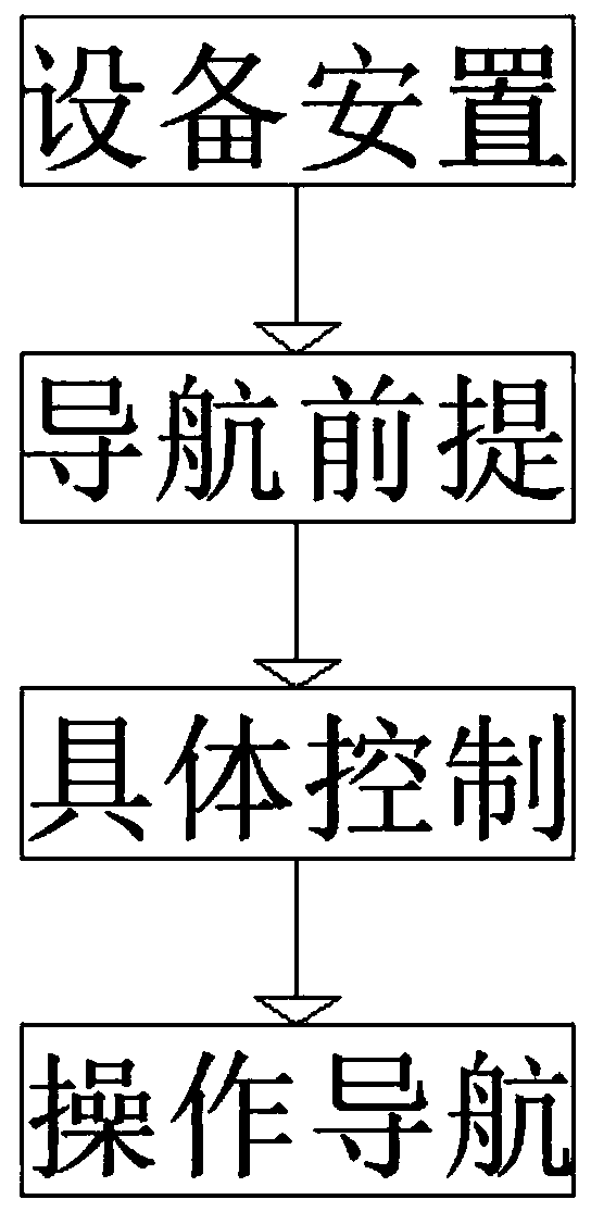
[0021] Such as figure 1 A kind of ultra-long-distance unmanned aerial vehicle navigation method described, comprises the following steps:

[0022] The first step is equipment placement. According to the needs of use, set two landmarks inside the UAV operating area, and at the same time establish a data processing server based on the network map, and connect the UAV control terminal through the communication network and the data processing based on the network map. The servers are connected to each other, the drone and the drone control terminal are connected to each other through the communication network, and the data processing server based on the network map is connected to the database of the meteorological department in the area where the dro...


PUM


Abstract

The invention relates to a novel ultra-long distance unmanned aerial vehicle navigation method, which comprises four steps such as equipment placement, navigation precondition, specific control and operation navigation. The method is simple in system construction structure, flexible and convenient to use, good in universality, high in expansion capacity and fault resistance and high in operation automation degree. On the one hand, two landmarks are set, an electric signal is transmitted through an unmanned aerial vehicle, and the location of the unmanned aerial vehicle is positioned, so that the positioning for the unmanned aerial vehicle is enabled to be accurate, and the follow-up operation is facilitated. Meanwhile, real-time monitoring is performed on an operating area of the unmannedaerial vehicle through a server according to a database of the meteorological department so as to avoid influences of the severe weather. On the other hand, both the front and the back of the unmannedaerial vehicle are provided with an ultrasonic detector, thereby being convenient for detecting the surrounding environment, and avoiding damage imposed on the unmanned aerial vehicle by obstacles orbirds in the environment.

Description

technical field [0001] The invention relates to an ultra-long-distance unmanned aerial vehicle navigation method, which belongs to the technical field of unmanned aerial vehicles. Background technique [0002] Unmanned aircraft, referred to as "unmanned aerial vehicle", or "UAV" in English, is an unmanned aircraft that is controlled by radio remote control equipment and its own program control device, or is completely or intermittently operated autonomously by an on-board computer. Existing drone navigation methods are not suitable for ultra-long-distance navigation. At ultra-long distances, it is difficult to control the accuracy of the position of the drone. Moreover, due to the long distance of the drone, if bad weather occurs, it is difficult to timely Retraction is prone to accidents and economic losses. At the same time, when the distance is too long, the unfamiliar environment may cause obstacles or birds in the environment to cause damage to the drone. Contents of ...

Claims


Application Information

Patent Timeline
Patent Type & Authority Patents(China)
IPC IPC(8): G01S5/12G01S5/02G01S15/93G01C21/20
CPCG01C21/005G01C21/20G01S5/0257G01S5/12G01S15/93
Inventor 徐丽尚书飞徐芳邹素英
Owner 浙江翔龙航空科技有限公司
Why Eureka
Try Eureka