Beacon structure, pavement, sensing device, mobile machine, system and method

A technology of mobile machines and sensing devices, which is applied in the fields of intelligent networked vehicles, unmanned driving, mobile robots, and target positioning. It can solve the problems of low GPS positioning accuracy, lack of flexibility, high cost of laser radar and camera positioning, and achieve Overcome high cost and benefit high precision effect

Active Publication Date: 2019-01-08
深圳市波特立物联科技有限公司
View PDF7 Cites 1 Cited by
  • Summary
  • Abstract
  • Description
  • Claims
  • Application Information

AI Technical Summary

Problems solved by technology

Among them, GPS positioning technology can only be used outdoors and cannot be used indoors because satellite positioning signals are easily affected by obstructions. Secondly, it is also easily affected by environmental weather outdoors, resulting in no signal or weak signal. Third, GPS positioning accuracy is low. Unstable; magnetic stripe guided two-dimensional code positioning technology can only follow a fixed route, lacking flexibility; lidar and camera positioning are costly and are easily affected by the environment and weather

Method used


Image

  • Beacon structure, pavement, sensing device, mobile machine, system and method
  • Beacon structure, pavement, sensing device, mobile machine, system and method
  • Beacon structure, pavement, sensing device, mobile machine, system and method

Examples


Embodiment approach

[0075] In one embodiment of the present invention, the high-precision positioning system further includes an electronic map database, and the electronic map database includes the corresponding relationship between color codes and positioning information; the acquiring the positioning information of the mobile machine specifically includes: querying The electronic map database obtains the positioning information of the mobile machine. Wherein, the electronic map database is a database, and the electronic map database records the corresponding relationship between the color coding in the beacon structure and the positioning information of the mobile machine. Because the color-coded information read by the mobile machine is the color and / or color combination, not the coordinate data, the coordinate information (X coordinate value and Y coordinate value ) and heading angle information (the heading angle in the X direction and the heading angle in the Y direction), etc. The electr...

Embodiment 1

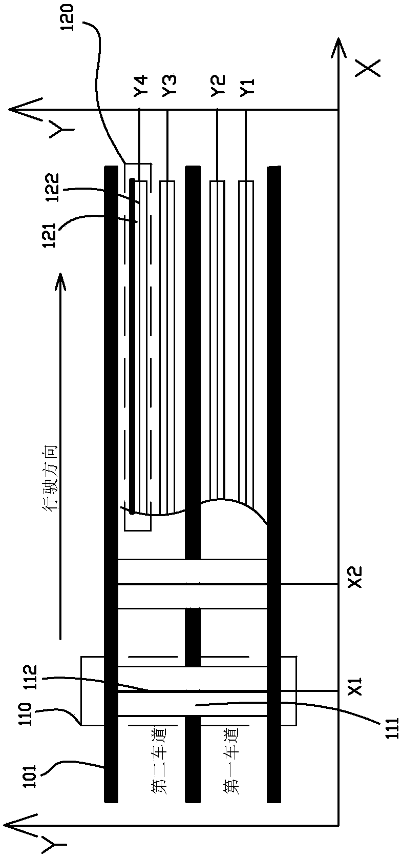
[0083] Such as Figure 6 As shown, in this embodiment, the road surface is a road surface, and the mobile machine is an unmanned vehicle. In this embodiment, the following design is made for the characteristics of driving on the road surface: First, due to the fast speed of driving on the road surface, the unmanned vehicle is required to read the road beacons quickly, so the color blocks are single-color blocks formed by single-color coding , which increases reading speed. Secondly, the establishment of the road surface coordinate system: because the road is sometimes a straight road and sometimes a curve, it is unified to establish an XY coordinate system based on the lane line 101. No matter whether the lane line 101 is a straight line or a curve, it is defined as a parallel lane line 101. The coordinate axis is the Y coordinate axis perpendicular to the lane line 101, so the X coordinate line can be a straight line or a curve. Lay multiple color beacon units along the X c...

Embodiment 2

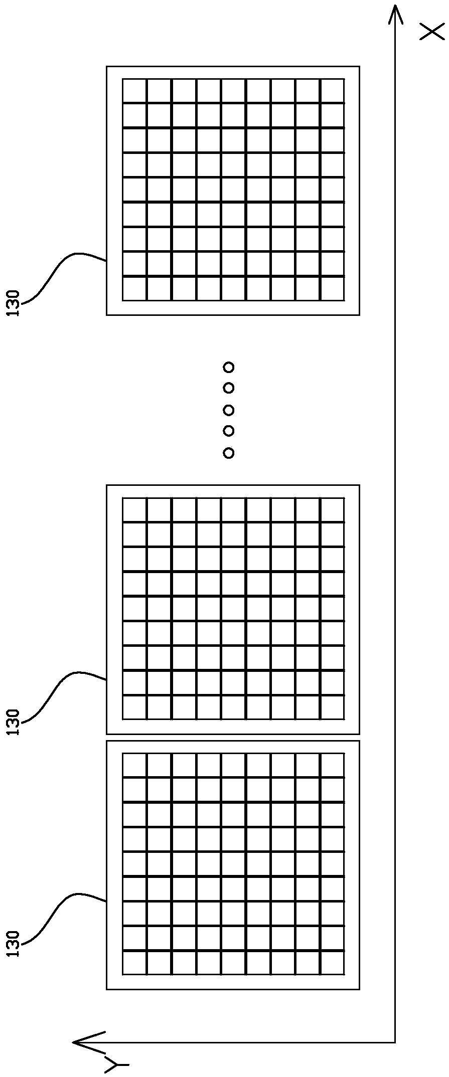
[0086] Such as Figure 7 As shown, in this embodiment, the application scenarios are roads in slow-moving areas such as squares, parking lots, and open spaces, and the mobile machine is a mobile robot. This embodiment makes the following design for the characteristics of road traffic in the slow-moving area: First, because the speed of the road in the slow-moving area is slow, the road is relatively complicated, and the color coding of the beacon structure requires a lot of color coding, so the color block adopts multi-color coding Formed multi-color mixed blocks. Secondly, the road surface coordinate line is a straight line, which can be spliced ​​with PVC floor tiles; thirdly, the road surface in the slow-moving area is evenly divided into multiple color beacon areas, and visible light (ambient light) can be used to locate data (different color blocks of visible light) As a third parameter to distinguish different color beacon units.

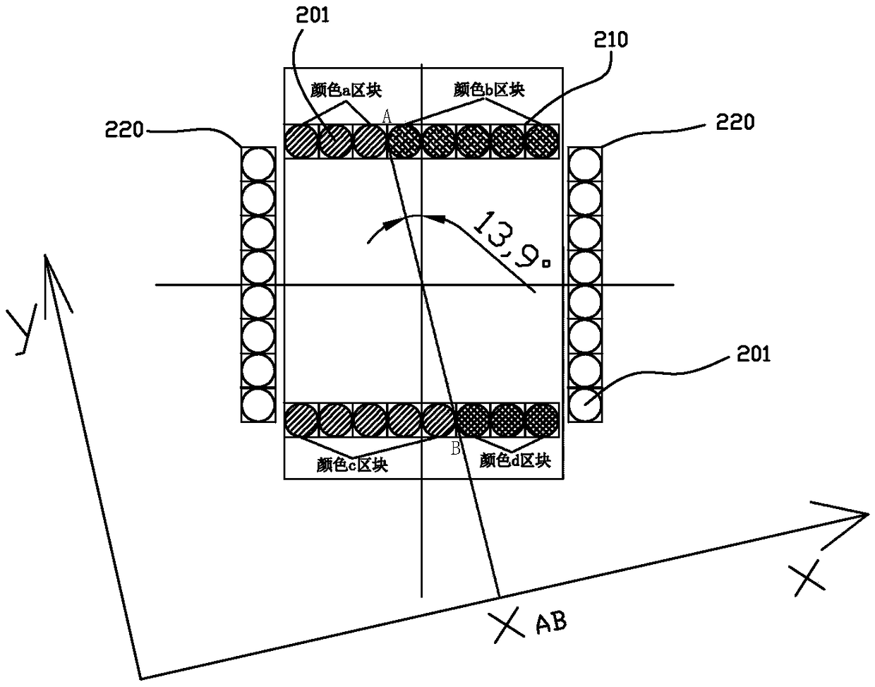
[0087] Specifically, in a color beaco...


PUM


Abstract

The invention discloses a beacon structure, a pavement, a sensing device, a mobile machine, a system and a method. The method determines the current position of the mobile machine by reading a beaconstructure set on the pavement, based on the color code information of the beacon structure and the position information corresponding to the color code. The beacon structure set on the pavement is read by the mobile machine, and the current position of the mobile machine is determined according to the color code information of the beacon structure and the position information corresponding to thecolor code, thereby solving the technical problems of high cost, poor stability and strong anti-interference ability of mobile machine positioning in the prior art, and realizing a beacon structure, apavement, a sensing device, a mobile machine, a system and a method beneficial to realizing low-cost, high-precision and high-stability positioning.

Description

technical field [0001] The invention relates to the fields of target positioning, mobile robots, intelligent networked vehicles, and unmanned driving, and in particular to a beacon structure, a beacon road surface, a beacon reading sensor device, a mobile machine, a positioning system, and a positioning method. Background technique [0002] Quantum dot: quantum dot is a nano-scale semiconductor. By applying a certain electric field or light pressure to this nano-semiconductor material, they will emit light of a specific frequency, and the frequency of the emitted light will change with the frequency of this semiconductor. Therefore, by adjusting the size of this nano-semiconductor, the color of the light emitted by it can be controlled. Since this nano-semiconductor has the characteristic of limiting electrons and electron holes (Electron hole), this characteristic is similar to Atoms or molecules in nature are therefore called quantum dots. [0003] Driverless car: also ca...

Claims


Application Information

Patent Timeline
Patent Type & Authority Applications(China)
IPC IPC(8): G01S5/16
CPCG01S5/16
Inventor 吴云肖
Owner 深圳市波特立物联科技有限公司
Why Eureka
Try Eureka