An intuitive multi-functional map projection teaching instrument and a realization method thereof

A technology of map projection and implementation method, which is applied in the field of teaching aids, can solve problems such as inability to be used flexibly, and achieve the effect of high flexibility

Inactive Publication Date: 2019-01-11
HANGZHOU NORMAL UNIVERSITY
View PDF3 Cites 1 Cited by
  • Summary
  • Abstract
  • Description
  • Claims
  • Application Information

AI Technical Summary

Problems solved by technology

Map projections can be divided into different categories according to different standards. There are few auxiliary teaching instruments on the market designed for earth projection, and it is almost impossible to use them flexibly. It can fully guarantee the user's subjective flexibility and ease of operation.

Method used


Image

  • An intuitive multi-functional map projection teaching instrument and a realization method thereof
  • An intuitive multi-functional map projection teaching instrument and a realization method thereof
  • An intuitive multi-functional map projection teaching instrument and a realization method thereof

Examples


Embodiment example 2

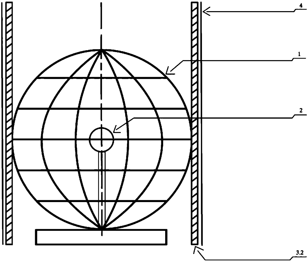
[0039] (2) Implementation Case 2—Orthographic Cylindrical Projection

[0040] In this projection mode, the positions of the earth model and the light source are the same as those in Case 1, that is, the earth is placed on a wooden base, and the LED light source is located at the center of the sphere. Cover the cylindrical projection board with the earth model, and the outline of the cylinder is tangent to the equatorial circle of the earth model, and then cover the projection paper on the cylindrical projection board, and draw the graticule effect of the positive axis cylindrical projection with a brush. Turn the drawn projection away to get a grid where the graticules are perpendicular to each other. In this projection mode, the latitude circle becomes a latitude line parallel to the east-west direction, and the meridian is a north-south vertical meridian network, and the meridian and latitude are perpendicular to each other. Observing the projection results can intuitively ...

Embodiment example 3

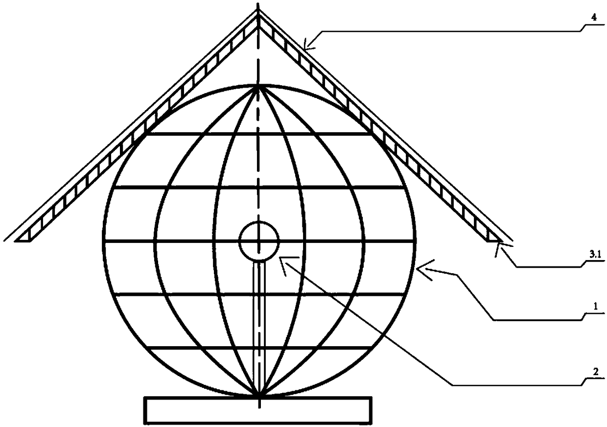
[0042] (3) Implementation Case 3 - Positive Axis Spherical Center Projection

[0043] Orthographic projection is a kind of azimuth projection. In this case, in order to test the projection effect of the hemisphere, in this implementation process, the earth sphere is split into two earth hemispheres, the southern hemisphere is taken out, and the northern hemisphere is fastened to the wooden base. On the seat, in order to ensure that the LED light source remains at the center of the earth, take out the original LED support frame and place the LED light source horizontally on the same plane in the northern hemisphere. Light up the light source, place the tangential North Pole of the planar projection board on the surface of the northern hemisphere, cover it with projection paper, use a brush to describe the projection effect at this time, and finally get a complete northern hemisphere azimuth projection graticule rendering. In this projection mode, the latitude line is a concentr...


PUM


Abstract

The invention discloses an intuitive multi-functional map projection teaching instrument and a realization method thereof. The instrument comprises an earth model, an LED point light source, a projection plate and a projection drawing pen. The Earth model is used to simulate the Earth sphere, which is a regular sphere and can be disassembled into two hemispheres, wherein the equatorial circle and0-degree longitude coil are the same size. The LED light source can be movably fixed at the earth model spherical center position or pole or any point outside the earth, which is used to characterizethe observation effect of different perspective point positions. A material of that projection plate is a transparent film, which can be use for drawing. In the actual design process, the instrument can be designed into conical, cylindrical, planar and custom projection panels, which can be cut according to the user's needs to achieve the desired projection effect. The invention has high flexibility by designing a separable simulated earth sphere and different types of light sources, and can fully compare and describe the characteristics and projection laws of different projection modes according to the imagination of the invention.

Description

technical field [0001] The invention belongs to a teaching aid, specifically relates to the demonstration of map projection process and the simulation and effect comparison of different projection modes, and provides an intuitive multifunctional map projection teaching instrument and a realization method thereof. Background technique [0002] For students in universities, colleges, research institutes, etc., when learning the "Cartography" course, when it comes to the relevant chapters of map projection, they need to understand and master a variety of earth projection methods, and are required to be able to choose the appropriate projection method according to actual needs. Considering that in the process of teaching knowledge in traditional classrooms, abstract description is not easy to understand, students have poor operability, and application analysis ability is weak. We have deeply analyzed the concepts and operating principles of different map projections and designed ...

Claims


Application Information

Patent Timeline
Patent Type & Authority Applications(China)
IPC IPC(8): G09B5/02G09B27/08
CPCG09B5/02G09B27/08
Inventor 庞毓雯徐俊锋黄雨馨问静怡
Owner HANGZHOU NORMAL UNIVERSITY
Why Eureka
Try Eureka