A fast updating method of road network based on trajectory adaptive clustering

An adaptive clustering and road network technology, applied in database update, instrument, character and pattern recognition, etc., can solve the problems of high noise of trajectory data, dependence on parameter settings, difficult to meet the needs of high-precision road network update, etc. Parameter setting simple effect

Active Publication Date: 2019-01-18
CENT SOUTH UNIV
View PDF9 Cites 35 Cited by
  • Summary
  • Abstract
  • Description
  • Claims
  • Application Information

AI Technical Summary

Problems solved by technology

However, due to the characteristics of high noise and uneven distribution density of trajectory data, the existing road network local update methods need to rely on more parameter settings (such as the number of clusters, thresholds of morphological algorithms, etc.), and can only deal with relatively simple It is difficult to deal with large-scale road network update problems due to the extraction of road change information
[0006] In general, although the current road network data update method based on the movement trajectory has received extensive attention from scholars and different departments, there are still several key issues in the existing movement trajectory-based road network update method that need to be resolved: (1) , The problem of too much dependence on parameter settings
Existing methods require more parameter settings in the process of clustering and rasterization, and the analysis results are more sensitive to these parameter settings, resulting in the subjectivity of road extraction results; how to choose the appropriate The parameters still require more manual intervention and debugging; (2), the existing algorithms are not capable of analyzing and processing complex scenes
It is mainly reflected in that due to the large difference in the distribution density of trajectory data in space, the existing methods based on clustering and rasterization are difficult to extract the complete information of changing roads, and it is easy to lose some newly added roads
In addition, the existing methods for some more complex new roads (such as T-shaped intersections, well-shaped road networks) generate relatively rough road geometry, which is difficult to meet the needs of high-precision road network updates; (3) Existing methods pay more attention to The extraction of road centerlines is relatively lacking in the extraction and update of semantic information such as road traffic directions and one-way and two-way roads.

Method used


Image

  • A fast updating method of road network based on trajectory adaptive clustering
  • A fast updating method of road network based on trajectory adaptive clustering
  • A fast updating method of road network based on trajectory adaptive clustering

Examples


Embodiment Construction

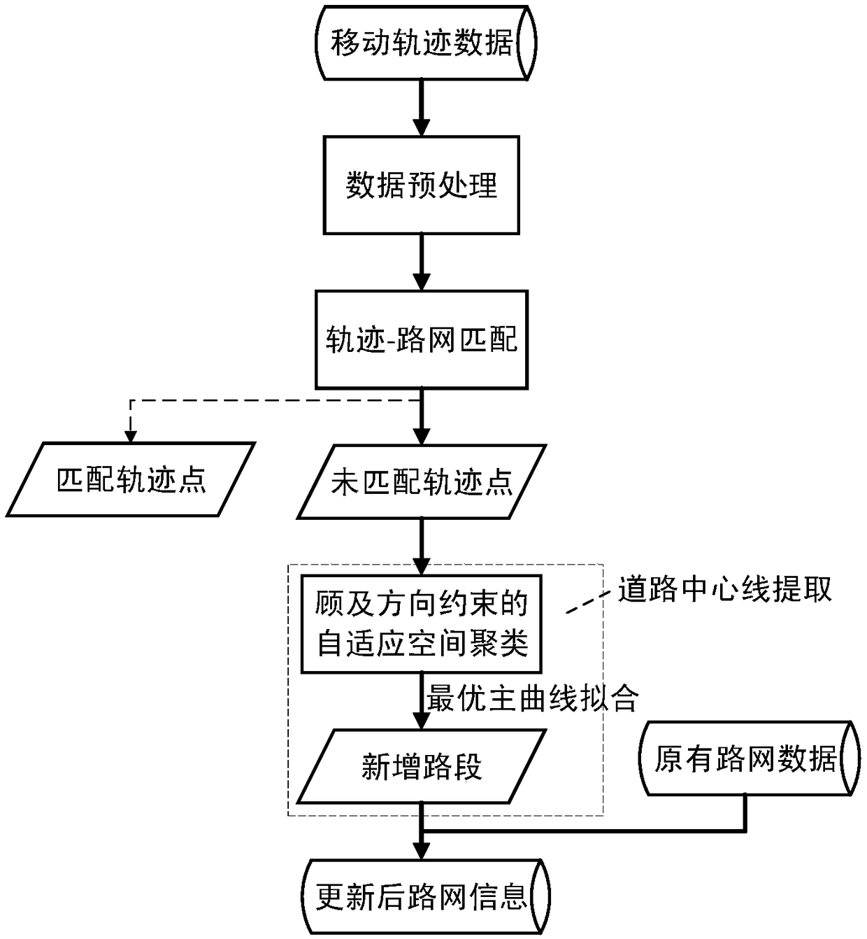
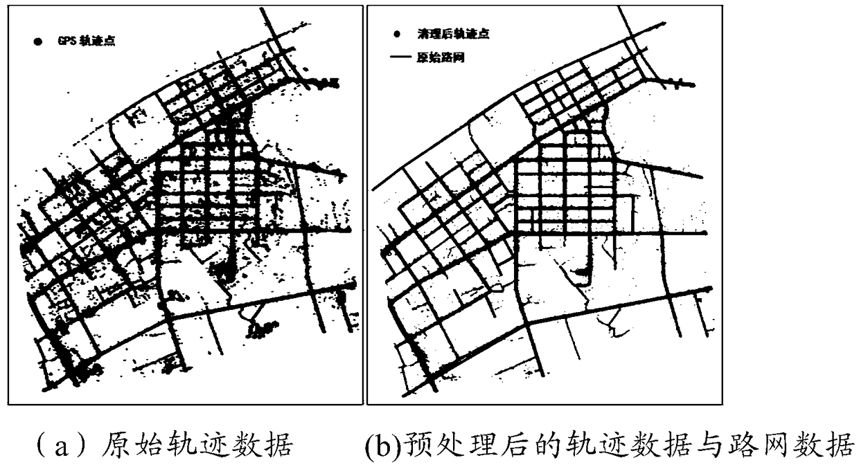
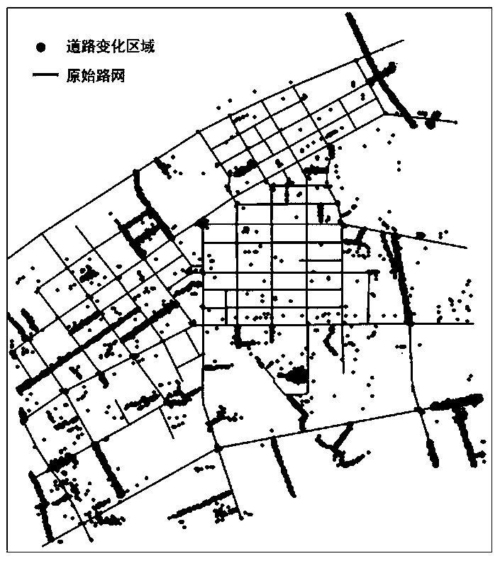
[0027] The specific implementation manners of the present invention will be further described below in conjunction with the drawings and examples. The following examples are only used to illustrate the technical solution of the present invention more clearly, but not to limit the protection scope of the present invention.

[0028] The flow process of technical method proposed in the present invention is as figure 1 shown. Further, in order to make the purpose, technical solution and advantages of the present invention more clear, the present invention will be further described in detail below in conjunction with the accompanying drawings and implementations as examples. It should be understood that the specific embodiments described here are only used to explain the present invention, not to limit the present invention. After reading the present invention, modifications to various equivalent forms of the present invention by those skilled in the art fall within the scope def...


PUM


Abstract

The invention provides a fast updating method of road network based on trajectory adaptive clustering, characterized in that the method comprises: whether the trajectory points match with the originalroad network is judged by the distance constraint condition and the direction constraint condition between the collected moving trajectory data and the acquired original road network data, Unmatchedtrajectory points are obtained by matching results, Adaptive trajectory clustering is carried out for the unmatched trajectory points, and for each trajectory clustering, the curve fitting of the trajectory points is carried out by using the optimal master curve fitting method, the road centerline is extracted, the driving direction of the road and the single/two-way information are recognized, and then the fusion of the changing road and the original road network is completed. The method can be used to identify the changing area of urban road network quickly, extract and update the fine geometrical structure of the changing road in complex scenario, and identify and update the semantic information of road driving direction, single/two-way and so on.

Description

technical field [0001] The invention relates to the research field of geographic information system and intelligent transportation, in particular to a method and system for fast updating of road network based on trajectory self-adaptive clustering. Background technique [0002] The road network is the basic data for major applications such as people's travel navigation, logistics distribution, and urban planning. It is also one of the basic geographic information that surveying and mapping, land and planning departments attach great importance to. At present, with the rapid development of urban construction in our country, the urban road network often changes. Facing the rapidly changing urban road network, how to ensure the current situation of road network data and realize the rapid update of road network data is a problem that departments such as surveying and mapping, transportation, and planning are eagerly concerned about. However, the existing digital mapping methods...

Claims


Application Information

Patent Timeline
Patent Type & Authority Applications(China)
IPC IPC(8): G06F16/23G06F16/29G06K9/62
CPCG06F18/23
Inventor 邓敏陈雪莹唐建波刘慧敏黄金彩
Owner CENT SOUTH UNIV
Why Eureka
Try Eureka