A positioning method of small unmanned aerial vehicle based on binocular vision

A technology of small drones and positioning methods, applied in image data processing, instruments, calculations, etc., can solve problems such as difficult positioning of drones, and achieve real-time processing, shorten processing time, and facilitate data query and management Effect

Active Publication Date: 2019-02-19
SOUTH CHINA UNIV OF TECH
View PDF8 Cites 29 Cited by
  • Summary
  • Abstract
  • Description
  • Claims
  • Application Information

AI Technical Summary

Problems solved by technology

[0003] Most of the current positioning systems of UAVs are designed based on GPS. It can be very difficult to locate UAVs in environments with poor GPS signals outdoors and indoors without GPS signals.

Method used


Image

  • A positioning method of small unmanned aerial vehicle based on binocular vision
  • A positioning method of small unmanned aerial vehicle based on binocular vision
  • A positioning method of small unmanned aerial vehicle based on binocular vision

Examples


Embodiment

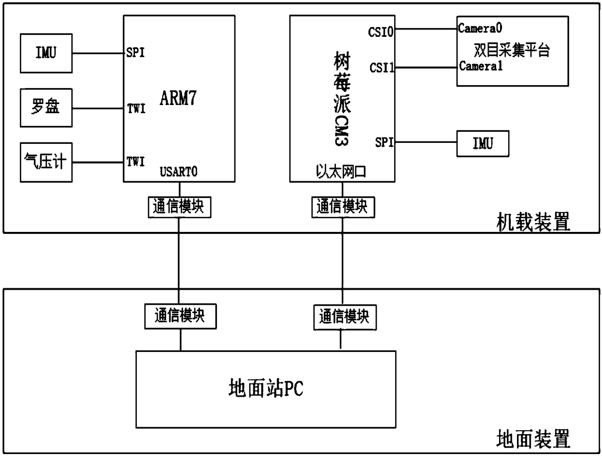
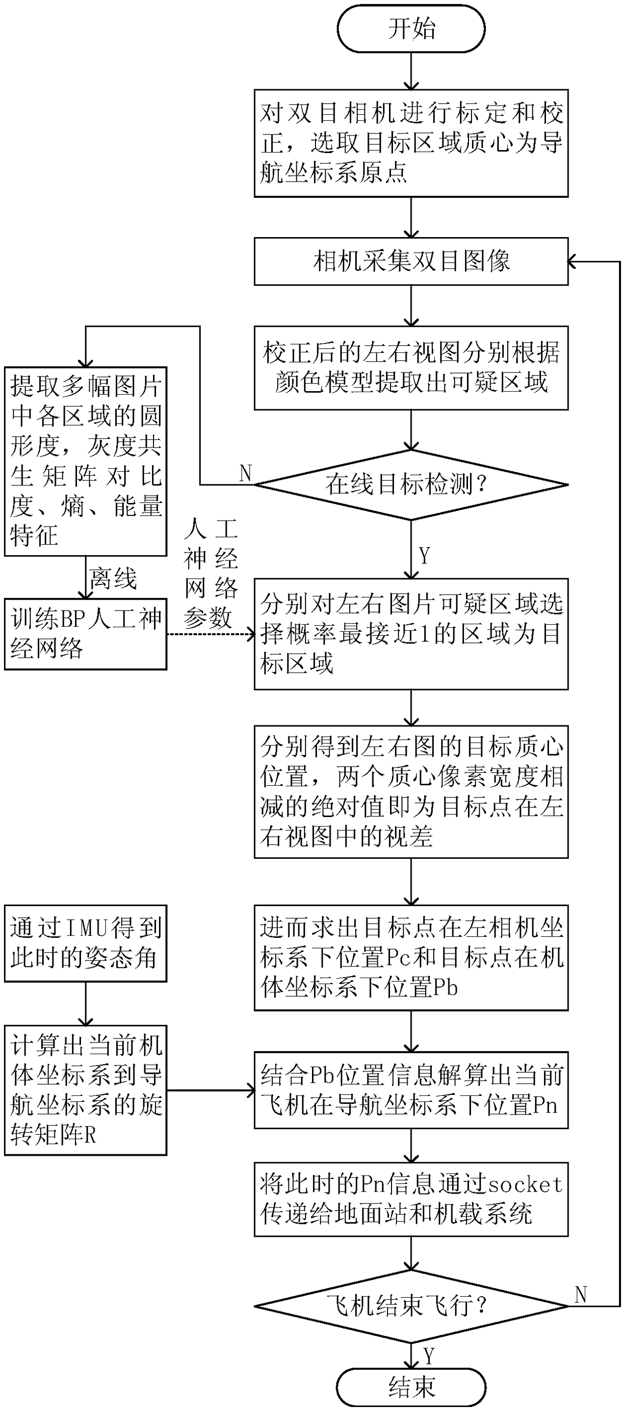
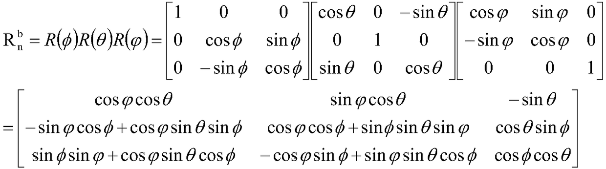
[0021] Such as figure 1 As shown, it is a block diagram of the hardware system structure of the small UAV positioning method based on binocular vision provided in this embodiment. The airborne system is based on the ARM7 as the main controller, and the normal working process of the aircraft is realized based on the ARM7. The image acquisition, processing and calculation platform is based on the Raspberry Pi CM3, on which the binocular acquisition platform connected by two CSI interfaces is used to acquire binocular images, and the inertial measurement unit is used to calculate the attitude angle and body of the aircraft at each moment The coordinates are relative to the rotation matrix of the initial position. The airborne system and the Raspberry Pi CM3 core board communicate with the ground station through socket programming. The ground station can receive the position of the aircraft in the navigation coordinate system at each time in real time.

[0022] This embodiment als...


PUM


Abstract

The invention discloses a positioning method of a small unmanned aerial vehicle based on binocular vision, which includes the following steps: using a ground target as a reference, selecting the target centroid as the origin of the navigation coordinate system, wherein the binocular camera fixed on the computer is based on the V4L2 interface to collect the image of the object in real time; By means of the object detection algorithm based on color model and artificial neural network algorithm to remove the disturbance region in the image, extracting the target area from the left and right viewsprecisely, the difference in the width of the target centroid pixel between the two images is the parallax of the target point; combined with binocular ranging and camera calibration parameters, theposition of the target point in the left camera coordinate system is calculated, and then the rotation matrix from the current airframe coordinate system to the initial airframe coordinate system is calculated based on the attitude angle information obtained by IMU, so as to calculate the coordinates of the UAV in the navigation coordinate system. The method effectively shortens the positioning time of the unmanned aerial vehicle (UAV) and is beneficial to the real-time processing of the aircraft position.

Description

technical field [0001] The invention relates to the technical field of binocular vision and UAV positioning, in particular to a small UAV positioning method based on binocular vision. Background technique [0002] At present, drones are widely used in express transportation, disaster rescue, surveying and mapping, aerial photography and other fields. For a long time to come, drones will still be a very hot research topic, and it will further change people's future work and life. . When UAVs perform almost all tasks, such as fire detection, surveying and mapping, transportation, etc., it is necessary to obtain its positioning information in real time for subsequent processing. Therefore, the research on navigation and positioning in the field of UAV is very necessary. [0003] Most of the current positioning systems of UAVs are designed based on GPS, but the positioning of UAVs becomes very difficult in the environment where the outdoor GPS signal is not good and there is n...

Claims


Application Information

Patent Timeline
Patent Type & Authority Applications(China)
IPC IPC(8): G06T7/73G06T7/246G06T7/60G06T7/45
CPCG06T7/246G06T7/45G06T7/60G06T7/73
Inventor 裴海龙谢俊文
Owner SOUTH CHINA UNIV OF TECH
Why Eureka
Try Eureka