Satellite borne double-side looking wide swath interference imaging height gauge base line inclination angle estimation method

A technology of altimeter and baseline, applied in radio wave measurement system, radio wave reflection/re-radiation, utilization of re-radiation, etc. It can solve the problems of complex methods, large amount of calculation, and inability to revisit frequently, and achieve simple methods and estimation high precision effect

Active Publication Date: 2019-03-01
NAT SPACE SCI CENT CAS
View PDF5 Cites 4 Cited by
  • Summary
  • Abstract
  • Description
  • Claims
  • Application Information

AI Technical Summary

Problems solved by technology

One is the external calibration method relying on ground control points. This method has high requirements for the selection, layout and measurement of ground control points. It is often difficult to implement and cannot be revisited frequently; the other is based on altimeter observations. The data itself is used to jointly estimate the baseline length, baseline inclination, and interferometric phase system deviation. This type of method is relatively complicated and requires a large amount of calculation.

Method used


Image

  • Satellite borne double-side looking wide swath interference imaging height gauge base line inclination angle estimation method
  • Satellite borne double-side looking wide swath interference imaging height gauge base line inclination angle estimation method
  • Satellite borne double-side looking wide swath interference imaging height gauge base line inclination angle estimation method

Examples


Embodiment Construction

[0024] The present invention will be further described below in conjunction with the accompanying drawings.

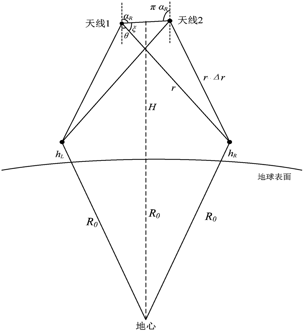
[0025] figure 1 It is a schematic diagram of the principle of interferometric imaging height measurement. The solution of the target height h can be expressed by the following formula:

[0026]

[0027] Where α is the inclination angle of the baseline, ξ is the angle between the baseline and the line of sight of the main antenna, θ is the viewing angle of the altimeter, r is the distance from the altimeter antenna to the target, H is the orbit height, and R 0 is the radius of the reference ellipsoid where the target is located.

[0028] Since it is necessary to calculate the target height value under different baseline inclination angles, h can be recorded as a function of α:

[0029] h=f(α) (2)

[0030] Baseline inclination angle α of left and right side view L and alpha R There is the following relationship: α L = π-α R , when there is an error α in the ba...


PUM


Abstract

The present invention discloses a satellite borne double-side looking wide swath interference imaging height gauge base line inclination angle estimation method. The method comprises the steps of: setting a range and a step length of a base line inclination value according to a right-side looking base line inclination measurement value to obtain a plurality of base line inclination values; inverting the sea surface height in each base line inclination value to obtain a left-side looking sea surface height vector and a right-side looking sea surface height vector; making difference of the left-side looking sea surface height vector and the right-side looking sea surface height vector to obtain a left-side looking differential vector and a right-side looking differential vector; calculatingaverage values in the swathes of the left-side looking differential vector and the right-side looking differential vector to draw two differential curves; and taking any one differential curve to perform x-axis symmetrical reversal to obtain a reversal differential curve, and calculating a base line inclination value of an intersection point of the reversal differential curve and the other differential curve as a right-side looking base line inclination estimation value of a height gauge, wherein the left-side looking base line inclination estimation value is a value by subtracting the right-side looking base line inclination estimation value from [Pi].

Description

technical field [0001] The invention relates to the technical field of interference imaging altimeter signal processing, in particular to a method for estimating the baseline inclination angle of a space-borne double side-view wide swath interference imaging altimeter. Background technique [0002] The interferometric imaging altimeter is a new type of radar altimeter developed in recent years. It adopts small-angle deviation from the zenith observation and short-baseline interferometry method, and can realize high-precision sea level height measurement within a width of tens of kilometers or even hundreds of kilometers. The swath width can be doubled if the left and right side view is used. Compared with the traditional sub-satellite point observation altimeter, the interferometric imaging altimeter can greatly improve the efficiency of ocean observation and monitoring, and meet the observation needs of mesoscale and sub-mesoscale marine environments. For interferometric i...

Claims


Application Information

Patent Timeline
Patent Type & Authority Applications(China)
IPC IPC(8): G01S13/88G01S7/02
Inventor 翟文帅张云华石晓进董晓
Owner NAT SPACE SCI CENT CAS
Why Eureka
Try Eureka