
A seasonal lake bottom topography generation method based on multi-source data fusion

A multi-source data and seasonal technology, applied in the direction of complex mathematical operations, etc., can solve the problems of LiDAR terrain data without valid values, lake underwater terrain data with limited accuracy, and airborne LiDAR measurement conditions are high

Active Publication Date: 2019-03-08
江西省国土空间调查规划研究院
View PDF8 Cites 5 Cited by
  • Summary
  • Abstract
  • Description
  • Claims
  • Application Information

AI Technical Summary

Problems solved by technology

[0004]Although the airborne LiDAR can realize land surface terrain data acquisition in a large area on the surface, the LiDAR point cloud has almost no echo signal in the water body, so the LiDAR terrain data is in the No valid value in water body range
And airborne LiDAR has high measurement conditions and high cost
[0005]Remote sensing images cover a large area, but are affected by many factors such as water body absorption, scattering, transparency, sediment content, etc., and can be used for terrain acquisition in areas without water on the ground. However, the accuracy of underwater topographic data of lakes obtained from remote sensing images is limited.
Therefore, there is currently no method that can effectively measure the bottom topography of seasonal lakes

Method used


Image

  • A seasonal lake bottom topography generation method based on multi-source data fusion
  • A seasonal lake bottom topography generation method based on multi-source data fusion
  • A seasonal lake bottom topography generation method based on multi-source data fusion

Examples


Embodiment Construction

[0034] The technical solutions in the embodiments of the present invention will be clearly and completely described below in conjunction with the drawings in the embodiments of the invention, but it should be understood that the protection scope of the present invention is not limited by the specific embodiments.

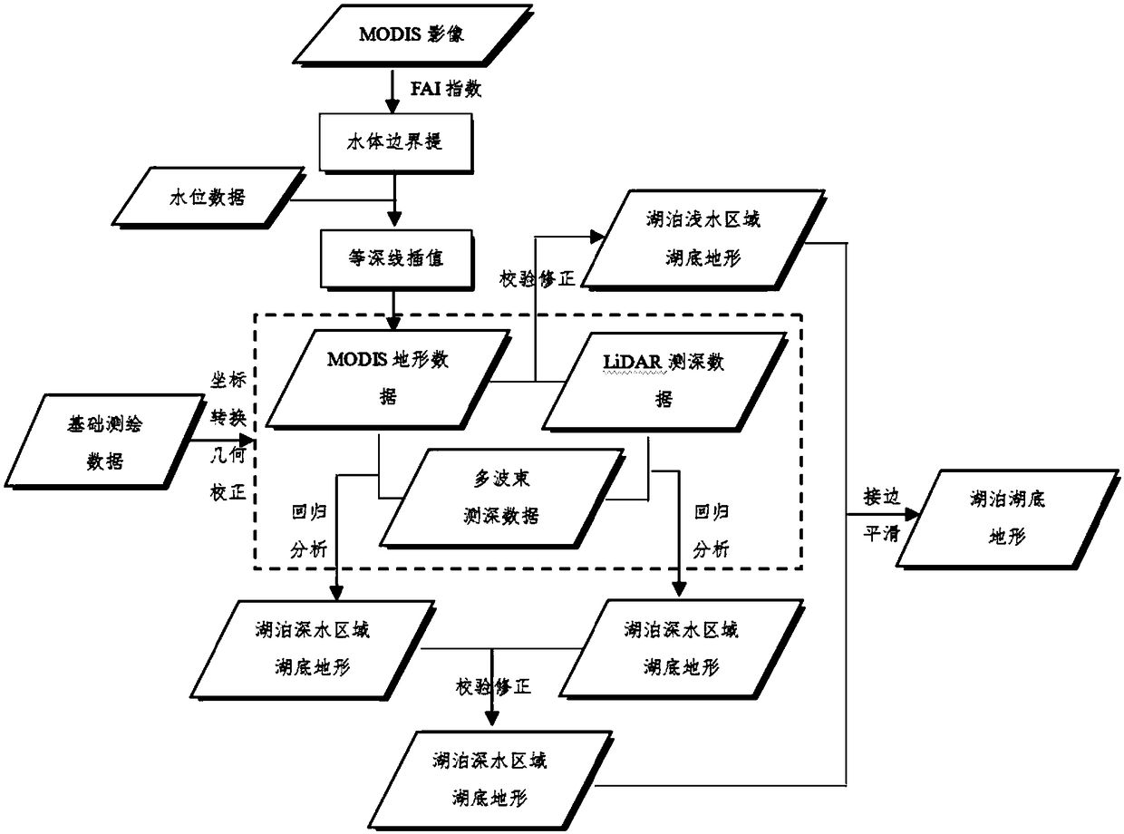
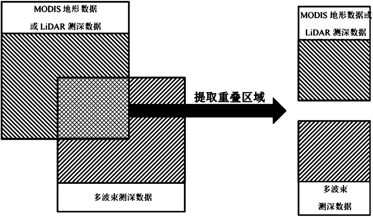
[0035] refer to Figure 1-2 , the present invention provides a method for generating seasonal lake bottom terrain based on multi-source data fusion, including:

[0036] Step 1: Collect multi-source data of underwater topography in the dynamically changing area of ​​the lake: MODIS topographic data, LiDAR topographic data, multi-beam bathymetry data;

[0037] Among them, the MODIS remote sensing image acquisition steps are as follows:

[0038] The MODIS image used in the present invention has a time resolution of 1-2 days and a scanning width of 2330km. With high time resolution, images that cannot be used due to clouds covering the target area or target object gho...


PUM


Abstract

The invention discloses a seasonal lake bottom topography generation method based on multi-source data fusion, and relates to the technical field of lake bottom topography generation. The method of the invention aims at the seasonal lakes with large coverage area, uses the basic surveying and mapping data, optical remote sensing image data, LiDAR data, multi-source data such as multi-beam bathymetric data to obtain seasonal lake bottom topography, to make full use of the advantages of each type of data, circumvent its shortcomings, Correlation analysis of data. By constructing multiple regression equation to calculate and generate the topography of deep water area of lake bottom, then, the bilinear interpolation method is used to generate the topography of the shallow water area of the lake bottom, at the same time, by considering the smoothing processing of the indirect crevice of the image, the complete topography of the seasonal lake bottom can be obtained, which not only shortens the time period of on-the-spot survey of the lake topography, but also ensures the integrality and high precision of the lake topography data, and optimizes the production efficiency of the lake bottomtopography data of the seasonal lake with large area.

Description

technical field [0001] The invention relates to the technical field of lake bottom terrain generation, in particular to a method for generating seasonal lake bottom terrain based on multi-source data fusion. Background technique [0002] At present, methods such as multi-beam bathymetry, airborne LiDAR or remote sensing images are generally used to measure the bottom of seasonal lakes with a large coverage area. [0003] Although the multi-beam bathymetry has high precision and high timeliness, it is limited by the measurement conditions, and the time period required for the complete area measurement or full-coverage scanning measurement of the lake by using the multi-beam bathymetry system is relatively long. Therefore, when using a multi-beam bathymetry system to observe waters, select more typical areas for measurement or use interval surveying lines to obtain topographic data of the lake bottom, and use other sources of data to supplement it. [0004] Although airborne ...

Claims


Application Information

Patent Timeline
IPC IPC(8): G06F17/18
CPCG06F17/18
Inventor 廖明伟廖明万冉冉袁武彬万佩璇廖永皓
Owner 江西省国土空间调查规划研究院
Learn More