An improved IHS transform remote sensing image fusion method and system

A remote sensing image and fusion method technology, applied in the field of remote sensing image processing, can solve problems such as image spectral distortion, and achieve the effect of preventing information waste, maintaining detailed information, and reducing information loss.

Active Publication Date: 2019-03-08
CHINA CENT FOR RESOURCES SATELLITE DATA & APPL
View PDF8 Cites 8 Cited by
  • Summary
  • Abstract
  • Description
  • Claims
  • Application Information

AI Technical Summary

Problems solved by technology

However, this algorithm has two obvious disadvantages: one is that it can only process information in three bands of red, green, and blue, while domestic satellite multispectral bands are generally set to four or more; When the range is inconsistent with the multi-spectrum, the spectrum of the fused image is greatly distorted

Method used


Image

  • An improved IHS transform remote sensing image fusion method and system
  • An improved IHS transform remote sensing image fusion method and system
  • An improved IHS transform remote sensing image fusion method and system

Examples


Embodiment

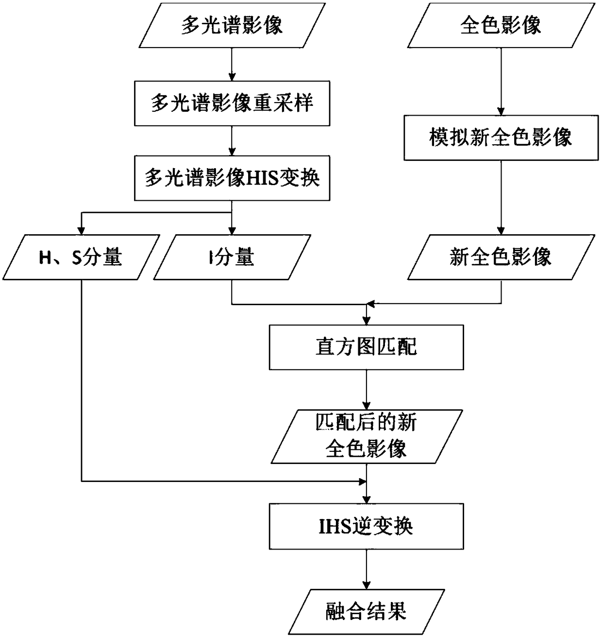
[0108] Taking Gaofen No. 2 panchromatic and multispectral images as an example to carry out fusion experiments, the traditional HIS fusion and the improved HIS fusion method proposed by the present invention are used for comparative experiments, and the average gradient, entropy, correlation coefficient and spectral distortion are used as objective evaluation criteria . Result evaluation is shown in Table 1, as can be seen the technical effect of the present invention.

[0109] Table 1 Fusion evaluation results

[0110]

[0111] It can be seen from the table that the average gradient and entropy of the images generated by the improved HIS and IHS fusion methods have little change, indicating that the two methods have little difference in the amount of information and detailed information, but the improved correlation coefficient method has increased from 0.58 to 0.90. Distortion reduced from 18.68 to 6.76.


PUM


Abstract

An improved IHS transform remote sensing image fusion method and system comprises the following steps of (1) resampling a multi-spectral image to achieve the resolution of a panchromatic image; (2) performing IHS transformation on the resampled multispectral images to obtain I, H and S components respectively; (3) simulating new panchromatic image; 4) taking that I component image histogram as a reference, matching the new panchromatic image with the histogram to obtain the match panchromatic image Inew; (5) carrying out the inverse IHS transform by replacing I component with Inew component ofthe panchromatic image after histogram matching, so as to complete remote sensing image fusion. The object of the invention is to improve the IHS transform fusion rule, so that the spectrum range ofthe panchromatic image and the multi-spectral image is consistent, and the brightness and contrast of the fusion result are not lower than those before the fusion.

Description

technical field [0001] The invention relates to an improved IHS transformation remote sensing image fusion method and system, belonging to the technical field of remote sensing image processing. Background technique [0002] Remote sensing images are one of the ways to obtain spatial information, and spatial resolution and spectral resolution are two important indicators to measure the quality of remote sensing images. Due to the limitation of data storage equipment on remote sensing satellites, domestic satellite optical cameras generally adopt the setting method of high spatial resolution of panchromatic images and low spatial resolution of multispectral images. Panchromatic images cannot display the color of ground features and are not aesthetically pleasing, while multi-spectral images can give RGB colors to different bands to obtain color images, but the resolution is low and cannot meet application requirements. In order to obtain high-resolution color images, it is n...

Claims


Application Information

Patent Timeline
Patent Type & Authority Applications(China)
IPC IPC(8): G06T5/40G06T5/50
CPCG06T5/40G06T5/50G06T2207/10036G06T2207/10041G06T2207/20221
Inventor 易维曾湧
Owner CHINA CENT FOR RESOURCES SATELLITE DATA & APPL
Why Eureka
Try Eureka