
Method suitable for indoor plane 2D SLAM mapping of building

A technology of buildings and planes, applied in the directions of measuring devices, utilizing re-radiation, and re-radiation of electromagnetic waves, can solve the problems of cumbersome process, low map accuracy, long process cycle time, etc., achieving high surveying and mapping accuracy and huge commercial value. , the effect of good robustness

Inactive Publication Date: 2019-03-29
WUHAN UNIV OF SCI & TECH
View PDF7 Cites 14 Cited by
  • Summary
  • Abstract
  • Description
  • Claims
  • Application Information

AI Technical Summary

Problems solved by technology

[0007] In the whole process of surveying and mapping, firstly, the process is cumbersome, there are many tools used, the operation process is inconvenient, and the whole process cycle time is long, which is not very advisable; However, human participation will always be involved in the measurement process, which cannot be avoided by traditional surveying and mapping methods, because the measurement results include people's subjective perception of the environment, which will lead to low accuracy of the measured map

Method used


Image

  • Method suitable for indoor plane 2D SLAM mapping of building
  • Method suitable for indoor plane 2D SLAM mapping of building
  • Method suitable for indoor plane 2D SLAM mapping of building

Examples


Embodiment Construction

[0037] In order to make the object, technical solution and advantages of the present invention more clear, the present invention will be further described in detail below in conjunction with the examples. It should be understood that the specific embodiments described here are only used to explain the present invention, not to limit the present invention.

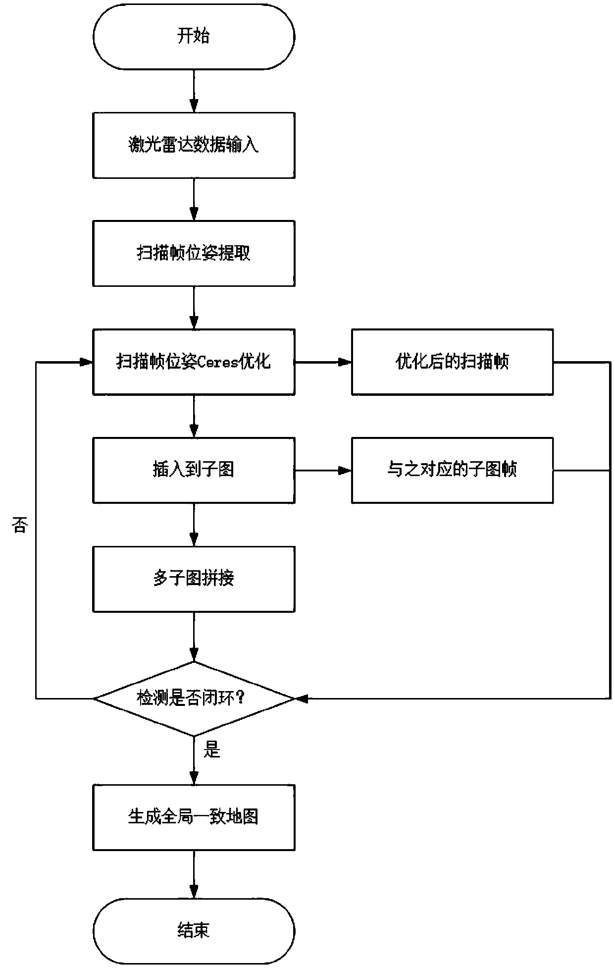
[0038] Such as figure 1 As shown, the present invention provides a method suitable for indoor plane 2D SLAM surveying and mapping, comprising the following steps:

[0039] Step S1: LiDAR startup and data transmission:

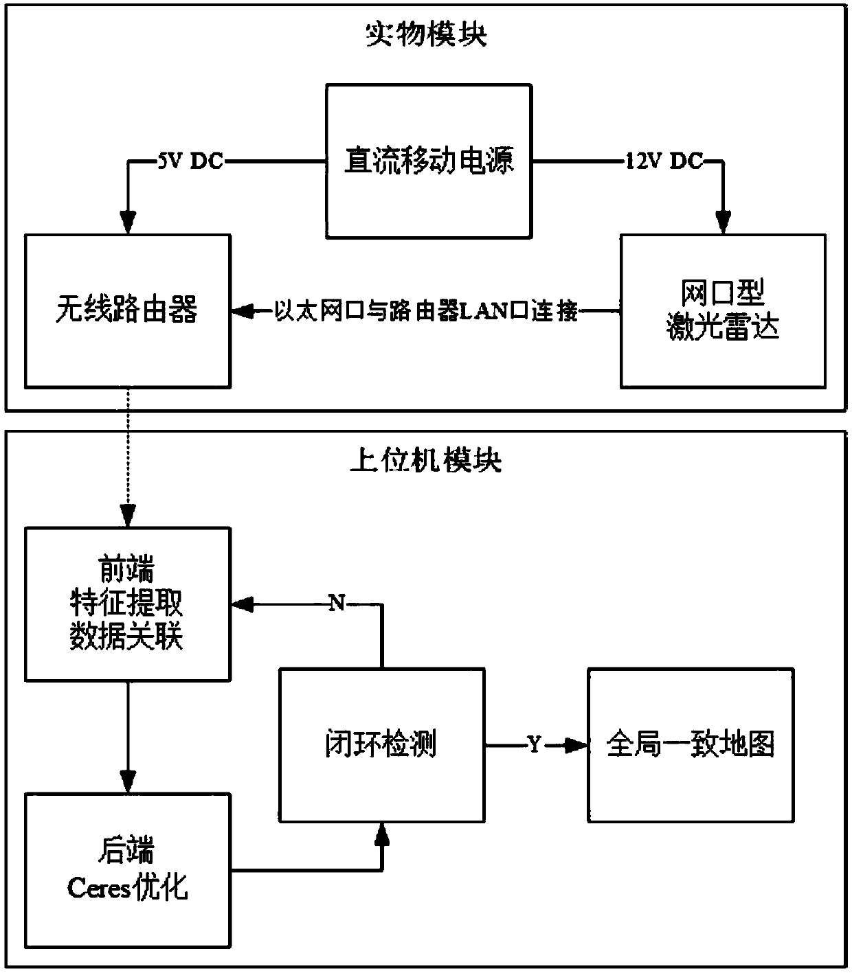
[0040] Step S11: Start the lidar: After the lidar is connected, the mobile power supplies power normally, the 5V power supply supplies power to the wireless router, and the 12V power supply supplies power to the lidar, and the lidar starts to work normally; figure 2 ;

[0041] Step S12: LiDAR data transmission: The LiDAR starts scanning, and the scanned data is transmitted to the PC in real time through ...


PUM


Abstract

The invention discloses a method suitable for indoor plane 2D SLAM mapping of a building. The method comprises the following steps that: firstly, a high-precision point cloud generated by the laser radar is used to extract a scanning key frame by using an improved graph optimization algorithm, After optimization of the scanning key frame, the scanning key frame is inserted into a sub-image; secondly, the optimized scan frame will be stored in a background for standby application in closed-loop detection; thirdly, through global optimization, the cumulative error in the SLAM process is reduced;and finally, the scanning frame stored in the background is transferred to perform closed-loop detection, and when the closed-loop is achieved, an accurate two-dimensional plan can be obtained. The mapping method provided by the invention is more accurate and much simpler than the traditional indoor mapping method, and the map provided by the laser radar can be used for robot navigation. The method can comprehensively and accurately construct the indoor plane environment so as to have great significance to the development of surveying and mapping disciplines.

Description

technical field [0001] The invention relates to robot SLAM and mapping technology, in particular to a method suitable for indoor plane 2DSLAM surveying and mapping of buildings. Background technique [0002] The traditional steps of measuring the indoor floor plan of a building are roughly as follows: [0003] 1. Collect the drawings of architectural design and construction, and divide the work area; [0004] 2. Prepare corresponding measuring instruments, such as range finder, box ruler and supporting drawing drawings, pencils and cameras; [0005] 3. Calculate the relevant data obtained from the measurement twice or more times, and calculate the average value; [0006] 4. Use the computer-aided design tool CAD to draw the floor plan and calculate the relevant data. [0007] In the whole process of surveying and mapping, firstly, the process is cumbersome, there are many tools used, the operation process is inconvenient, and the whole process cycle time is long, which is...

Claims


Application Information

Patent Timeline
IPC IPC(8): G01S17/89
CPCG01S17/89
Inventor 吴怀宇丁元浩洪运志肖洒蔡丽仪童雨聪刘家乐
Owner WUHAN UNIV OF SCI & TECH
Learn More