Method and system for extracting forest land from remote sensing image based on depth learning, storage medium, and electronic device

A remote sensing image and deep learning technology, applied in the field of remote sensing image processing, can solve the problems of difficult definition, poor extraction effect, different texture features, etc. The effect of accuracy

Active Publication Date: 2019-03-29
SUZHOU ZHONGKE IMAGE SKY REMOTE SENSING TECH CO LTD +2
View PDF4 Cites 17 Cited by
  • Summary
  • Abstract
  • Description
  • Claims
  • Application Information

AI Technical Summary

Problems solved by technology

[0004] Woodlands have obvious spectral characteristics, especially the high reflectance characteristics of green plants in the near-infrared band and the low reflectance characteristics in the red range of visible light, which have become the theoretical basis for constructing vegetation indices, so vegetation spectra have become one of the earliest basic remote sensing research objects Most of the traditional woodland extraction methods are based on the NDVI vegetation index plus a certain texture recognition method. However, due to the different density of the woodland itself and the limitations of traditional methods, the extraction ef

Method used


Image

  • Method and system for extracting forest land from remote sensing image based on depth learning, storage medium, and electronic device
  • Method and system for extracting forest land from remote sensing image based on depth learning, storage medium, and electronic device
  • Method and system for extracting forest land from remote sensing image based on depth learning, storage medium, and electronic device

Examples


Embodiment Construction

[0049] Below, the present invention will be further described in conjunction with the accompanying drawings and specific implementation methods. It should be noted that, under the premise of not conflicting, the various embodiments described below or the technical features can be combined arbitrarily to form new embodiments. .

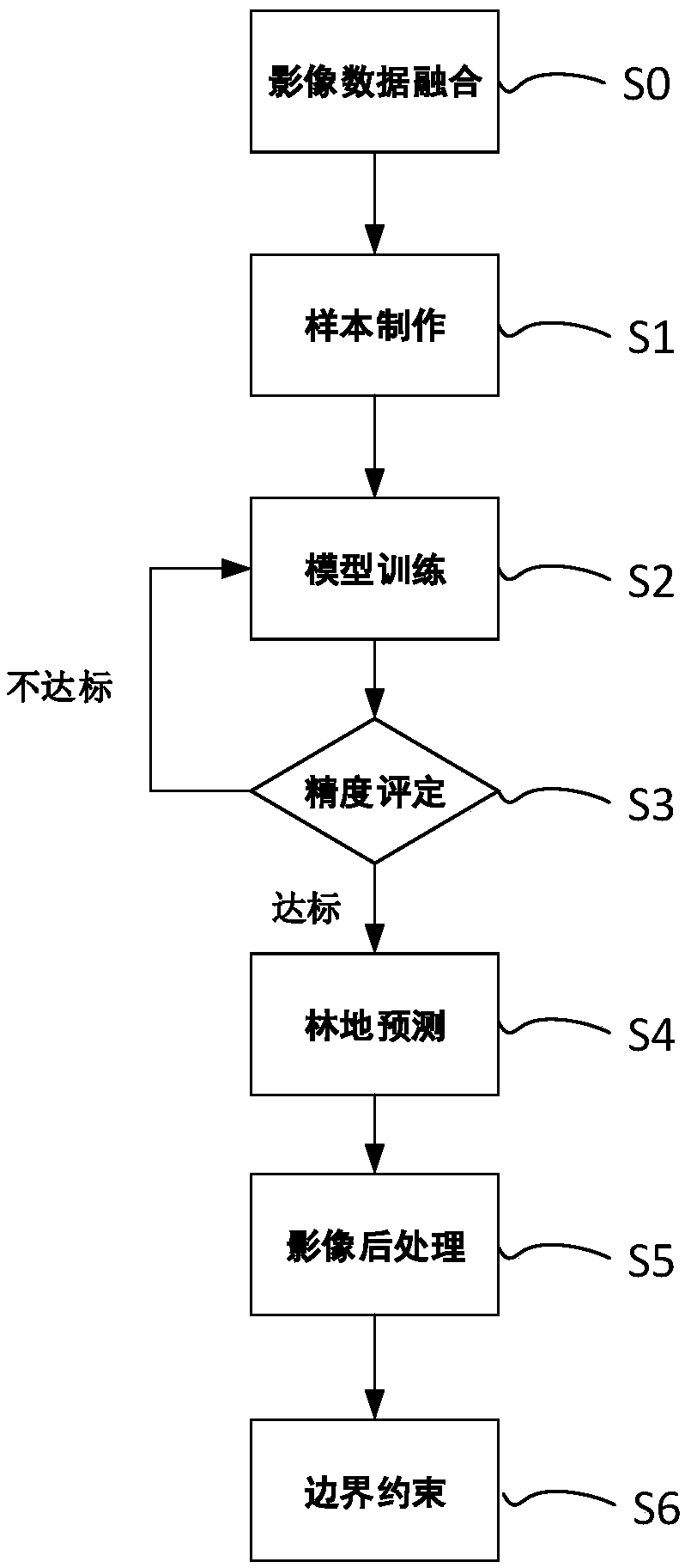
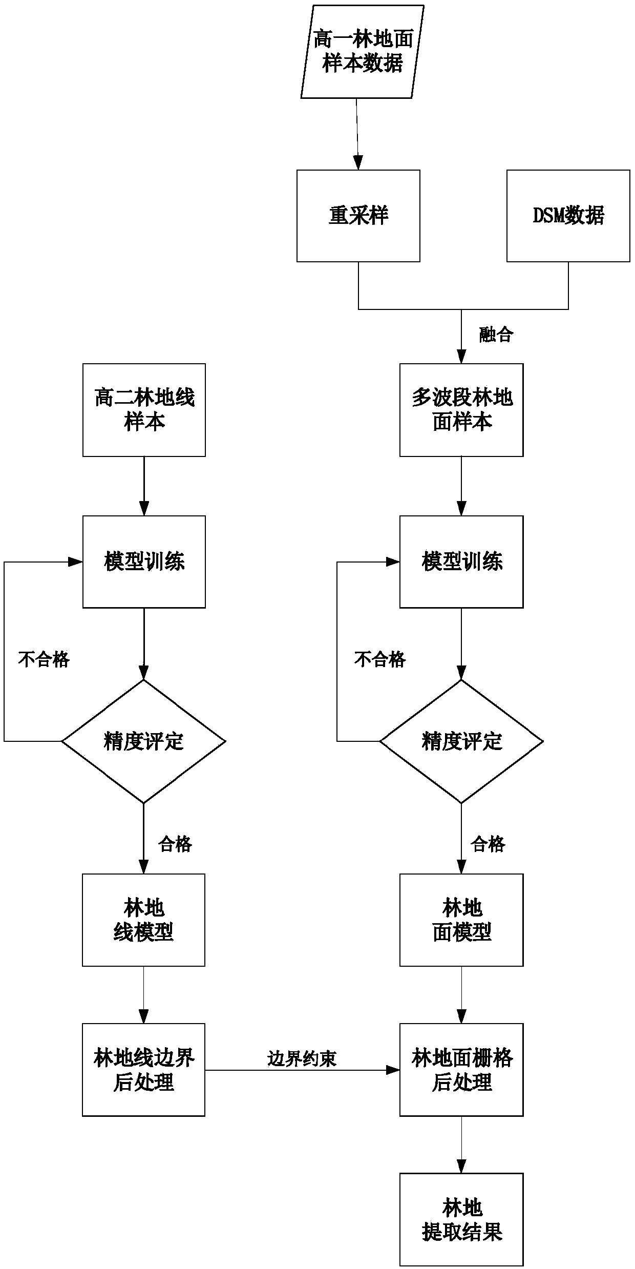
[0050] A method for extracting woodland from remote sensing images based on deep learning, such as figure 1 , figure 2 shown, including the following steps:

[0051] S0, image data fusion, the remote sensing image data of the first resolution is fused with the DSM data of the second resolution to obtain the fusion data of the second resolution, wherein the first resolution is higher than the second resolution; In the embodiment, by acquiring the four-band remote sensing image data of the first resolution and the DSM data of the second resolution, resampling the four-band remote sensing image data of the first resolution to the second resolution, and...


PUM


Abstract

The invention provides a method for extracting forest land from remote sensing images based on depth learning, which comprises the steps of image data fusion, sample making, model training, precisionevaluation and forest land prediction. The invention also relates to a remote sensing image woodland extraction system based on depth learning, a storage medium and an electronic device. The inventionintegrates digital terrain model, DSM data and four-band sample data are fuse, training data having five bands of information is obtained, input to a depth learning network model to obtain a forest land classification model containing DSM features by iterative iteration, Then the boundary extraction network RCF is used to extract the woodland boundary from remote sensing image as a constraint, soas to complete the accurate division of the woodland and make the boundary of the woodland more conform to the reality. The invention realizes automatic and efficient extraction of the woodland vector data, greatly improves the accuracy of the woodland extraction method of the remote sensing image, and shortens the time cost and human cost of manual drawing.

Description

technical field [0001] The invention belongs to the technical field of remote sensing image processing, and is a deep learning high spatial resolution remote sensing image woodland extraction method based on a digital surface model, which is mainly applied to the automatic extraction of forest land from sub-meter remote sensing images. Background technique [0002] Forest land plays an indispensable role in the human living environment. It is an important part of the ecological environment, one of the best symbols to reflect the regional ecological environment, and an important object of environmental remote sensing application research. The use of remote sensing technology to extract green forest information has a long history. Remote sensing can quickly and effectively detect the type, characteristics, growth and other information of large-scale forest land; the purpose of forest remote sensing information extraction is to effectively determine the distribution of plants on...

Claims


Application Information

Patent Timeline
IPC IPC(8): G06K9/00G06K9/62
CPCG06V20/188G06F18/214Y02A90/10
Inventor 周楠魏春山吴炜胡晓东夏列钢骆剑承郜丽静高星宇
Owner SUZHOU ZHONGKE IMAGE SKY REMOTE SENSING TECH CO LTD
Why Eureka
Try Eureka