
Topmark map building and robot positioning method

A technology for robot positioning and map construction, applied to instruments, measuring devices, surveying and navigation, etc., can solve problems such as inaccurate map construction results, and achieve the effect of reducing deviation, weakening positioning deviation, and improving construction accuracy.

Pending Publication Date: 2019-04-12
WUHU HIT ROBOT TECH RES INST
View PDF6 Cites 4 Cited by
  • Summary
  • Abstract
  • Description
  • Claims
  • Application Information

AI Technical Summary

Problems solved by technology

However, the existing top-mark-based map construction method calculates the positions of unknown landmarks in the map sequentially based on known landmarks, and the errors in the calculation process will be accumulated and propagated backwards. When the number of top marks is large, the map construction results are inaccurate.

Method used


Image

  • Topmark map building and robot positioning method

Examples


Embodiment Construction

[0031] In order to make the object, technical solution and advantages of the present invention clearer, the present invention will be further described in detail below in conjunction with the accompanying drawings and embodiments. It should be understood that the specific embodiments described here are only used to explain the present invention, not to limit the present invention.

[0032] In the present invention, the top label needs to be pasted on the roof where the robot needs to move, and the camera is set parallel to the roof. The camera needs to be calibrated before use to obtain the internal parameter matrix M of the camera. cam .

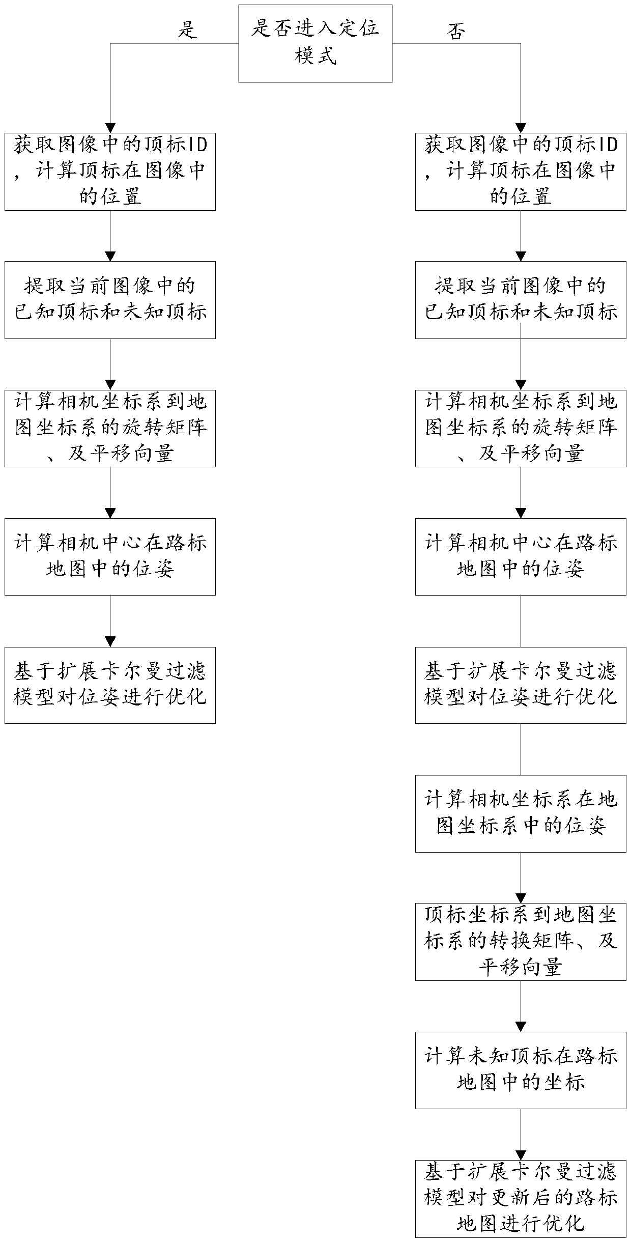
[0033] figure 1 It is a flow chart of the top-mark map construction and robot positioning method provided by the embodiment of the present invention. The method specifically includes the following steps:

[0034] S1. Judging whether to enter the positioning mode at present, if the judgment result is yes, enter the positioning mode, execut...


PUM


Abstract

The invention belongs to the technical field of automatic control, and provides a topmark map building and robot positioning method. The topmark map building and robot positioning method comprises thesteps: S1, whether a positioning mode is entered currently or not is judged, if yes, the positioning mode is entered, the step S2, the step S3 and the step S4 are executed, and if not, a mapping modeis entered, and the step S2 to the step S6 are executed; S2, topmarks in a current map are extracted, ID of the topmarks is obtained, and the positions of the topmarks in the map are calculated; S3,the known and unknown topmarks in the current map are extracted; S4, the pose of a robot in the current road sign map is calculated based on the three or more known topmarks; S5, a transition matrix R' and a translation vector t' from a topmark coordinate system to a map coordinate system are calculated; and S6, coordinates x<w> of the unknown topmarks in the road sign map are calculated based oncoordinates x<map> of the unknown topmarks in the topmark coordinate system, and the road sign map is updated. Positions of the unknown topmarks in the road sign map are calculated based on the transition matrix and the translation vector from the current topmark coordinate system to the map coordinate system, that is, the road sign map is built, and accumulation of errors can be weakened.

Description

technical field [0001] The invention belongs to the technical field of automatic control, and provides a top-mark map construction and robot positioning method. Background technique [0002] With the development of society and the advancement of technology, mobile robots are more and more deeply involved in human daily life, such as cleaning robots in the home, handling robots in factories, and food delivery robots in restaurants. If a mobile robot wants to realize all the above functions, it must know its own location accurately, that is, real-time positioning. The prerequisite for realizing the real-time positioning of the robot is to establish a map, which is the key to realizing robot navigation and other intelligent behaviors. Commonly used sensors for mobile robot mapping include cameras and lidar. Among them, the cost of laser radar hardware is relatively high, which is not conducive to the large-scale popularization and promotion of mobile robots. The use of camer...

Claims


Application Information

Patent Timeline
Patent Type & Authority Applications(China)
IPC IPC(8): G01C21/20
CPCG01C21/206
Inventor 陈智君李超曹雏清高云峰
Owner WUHU HIT ROBOT TECH RES INST
Learn More