Supercharge Your Innovation With Domain-Expert AI Agents!

Map matching system of integrated vehicle navigation in cave, and error correction method thereof

A technology of map matching and vehicle combination, applied in the field of vehicle navigation, can solve the problems of poor location information accuracy and untimely update, and achieve the effect of improved accuracy, high cost and small effect

Inactive Publication Date: 2019-04-16
NANJING UNIV OF SCI & TECH
View PDF5 Cites 0 Cited by
  • Summary
  • Abstract
  • Description
  • Claims
  • Application Information

AI Technical Summary

Problems solved by technology

[0004] The purpose of the present invention is to provide a map matching system and an error correction method for vehicle integrated navigation in caves. When vehicle navigation loses GPS signals in caves and tunnels, the accuracy of position information is poor and the update is not timely.

Method used


Image

  • Map matching system of integrated vehicle navigation in cave, and error correction method thereof
  • Map matching system of integrated vehicle navigation in cave, and error correction method thereof
  • Map matching system of integrated vehicle navigation in cave, and error correction method thereof

Examples


Embodiment Construction

[0025] The present invention will be described in further detail below in conjunction with the accompanying drawings.

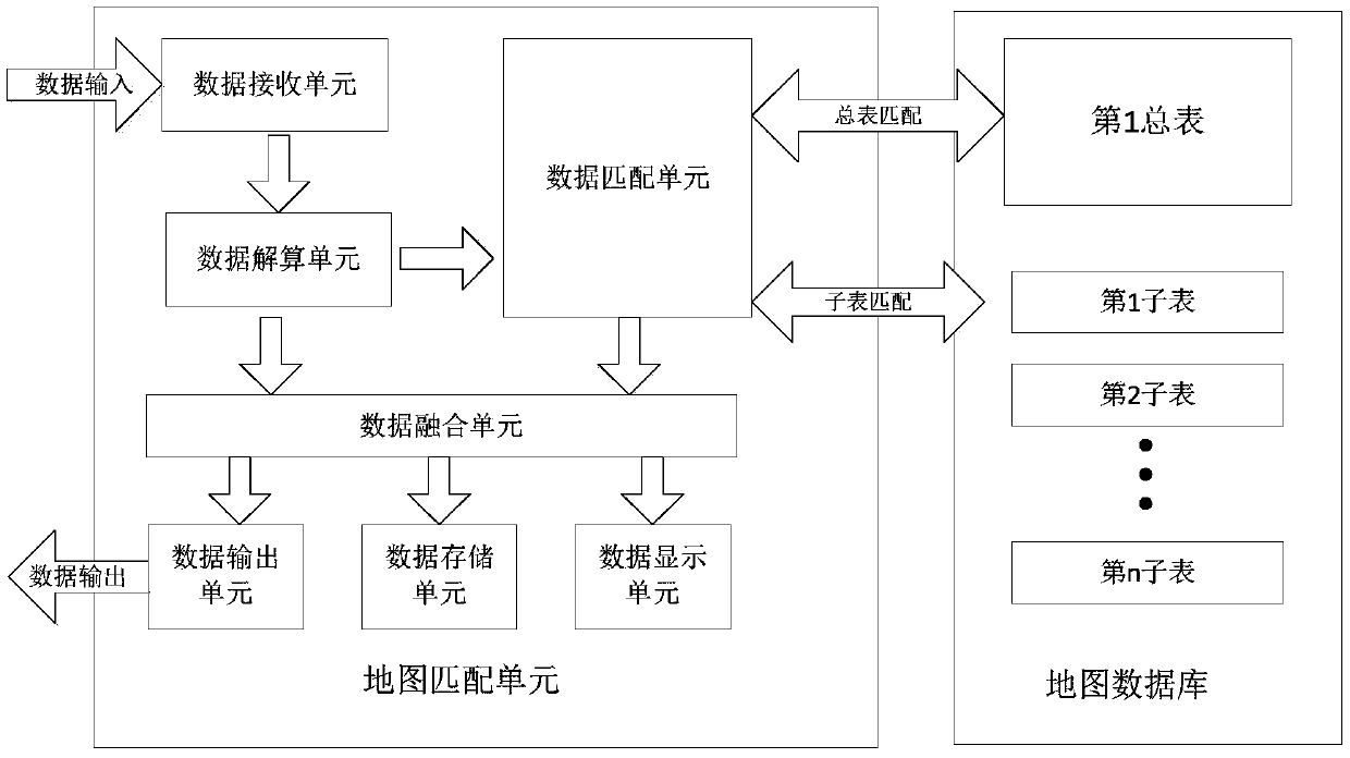
[0026] combine figure 1 , the map matching system of vehicle integrated navigation according to the present invention includes a map matching unit and a map database, wherein the map matching unit includes a data receiving unit, a data calculation unit, a data matching unit, a data fusion unit, a data output unit, and a data storage unit. unit and data display unit; the map database includes the first general table and several sub-tables, the first general table stores the longitude and latitude of the entrance and exit positions of all caves, and one sub-table corresponds to storing the longitude and latitude of a driving route in a cave, and each road is according to A certain driving distance collects a point and stores it in a sub-table, and a sub-table is created for each cave. The map database pre-stores the latitude and longitude standard values ​​of ...


PUM


Abstract

The invention discloses a map matching system of integrated vehicle navigation in a cave, and an error correction method thereof. The map matching system comprises a cave map database and a map matching unit; the map matching unit comprises a data receiving unit, a data solution unit, a data matching unit, a data fusion unit, a data output unit, a data storage unit and a data display unit; the mapdatabase comprises the first general table and several sub-tables; the data receiving unit receives data of integrated navigation; the data solution unit performs solution; the data matching unit completes matching of the integrated navigation and the map database, and performs error correction on the position information output by the integrated navigation; and finally, the data fusion unit outputs, stores and displays data after fusing the data. Thereby, the problem that the position information precision is poor in a condition that the vehicle navigation loses a GPS signal in a cave and tunnel can be solved; a matching algorithm having a two-layer nested structure is adopted; and the method has the advantages of being good in real-time performance, high in precision, low in cost and the like.

Description

technical field [0001] The invention belongs to the field of vehicle navigation, and in particular relates to a map matching system for vehicle integrated navigation in a cave and an error correction method thereof. Background technique [0002] In the development of human civilization, the research and development of navigation systems has a long history. In ancient times, people judged the location and direction by observing the sky, and later invented the compass. The legend about the compass in our country can be traced back to the Yanhuang period. With the advancement of science and technology, people's demand for location information is increasing; in the 1970s, the establishment of the United States' Global Positioning System (GPS) and the former Soviet Union's GLONAAS marked the gradual maturity of navigation and positioning technology. [0003] With the advancement of technology, many new vehicle navigation technologies such as integrated navigation have emerged. I...

Claims


Application Information

Patent Timeline
IPC IPC(8): G01C21/32
CPCG01C21/32
Inventor 丁垒朱欣华
Owner NANJING UNIV OF SCI & TECH
Features
  • R&D
  • Intellectual Property
  • Life Sciences
  • Materials
  • Tech Scout
  • Unparalleled Data Quality
  • Higher Quality Content
  • 60% Fewer Hallucinations
Learn More