Continuous positioning system and method for navigation signals inside and outside tunnel

A navigation signal and positioning system technology, applied in satellite radio beacon positioning system, radio wave measurement system, navigation through speed/acceleration measurement, etc., can solve problems such as WIFI positioning failure, navigation receiver positioning, influence, etc., to achieve Solve the effects of loss of positioning results and time discontinuity

Inactive Publication Date: 2019-05-10
HUNAN SATELLITE NAVIGATION INFORMATION TECH CO LTD
View PDF10 Cites 7 Cited by
  • Summary
  • Abstract
  • Description
  • Claims
  • Application Information

AI Technical Summary

Problems solved by technology

In the existing technology, there are many methods for indoor positioning, such as WIFI positioning, pseudolite positioning, etc., but none of them are suitable for the narrow and long channel scene such as tunnels. WIFI positioning cannot help the navigation receiver to locate, and multiple pseudolites need to be densely deployed , and the near-far effect and multipath effect are seriously affected

Method used


Image

  • Continuous positioning system and method for navigation signals inside and outside tunnel
  • Continuous positioning system and method for navigation signals inside and outside tunnel

Examples


Embodiment Construction

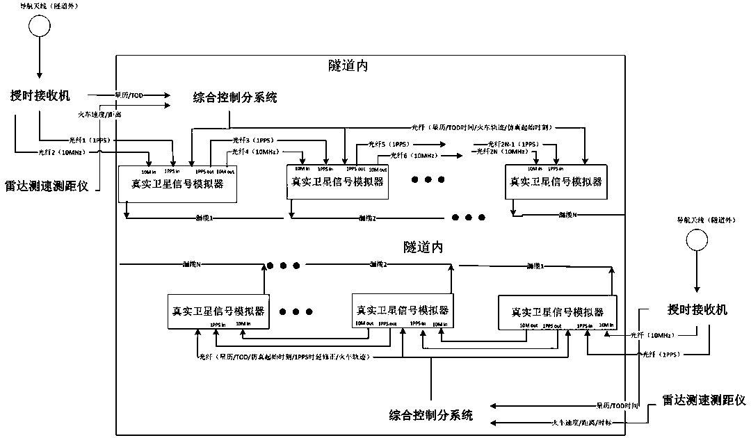
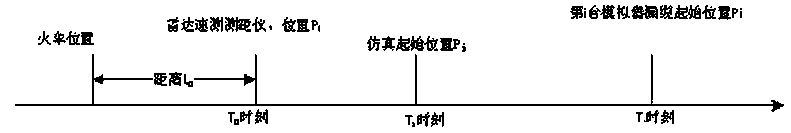
[0038] During the patent application stage of the present invention, the applicant also applied for a continuous simulation system for navigation and positioning inside and outside the tunnel, which is a simulation system for navigation and positioning in tunnels based on real satellite signal simulators (hereinafter referred to as "satellite navigation signal simulators"). One navigation receiver and its antenna outside the tunnel, integrated control system, N satellite navigation signal simulators inside the tunnel, optical cable and photoelectric converter for sending ephemeris and time information, 2N optical fibers and photoelectric for transmitting 1PPS and 10MHz It consists of converters, N leaky cables for radiation signals, etc. However, if this system wants to achieve a positioning accuracy of better than 10 meters, a satellite navigation signal simulator needs to be deployed every 20 meters. The distance of the leaky cable is very short, which will increase the diffi...


PUM


Abstract

The invention relates to a continuous positioning system and method for navigation signals inside and outside a tunnel. A radar velocity measuring and distance measuring instrument is used for measuring the arrival velocity and distance of a target, and marking a local time scale; a time service receiver is used for resolving TOD time and a satellite ephemeris, outputting 1PPS and 10MHz signals, and transmitting the signals to a satellite navigation signal simulator; a satellite navigation signal simulator and a leakage cable are alternately connected with each other, and used for performing simulation and transmitting satellite signals to the target in the tunnel; and a comprehensive control subsystem is used for reading the TOD time, the satellite ephemeris, speed and distance information with the local time scale as well as the position coordinates of the radar velocity measuring and distance measuring instrument, the satellite navigation signal simulator and the leakage cable, andcalculating a target trajectory and a simulation moment that the satellite navigation signal simulator needs to simulate. The radar velocity measuring and distance measuring instrument is erected outside the tunnel in combination with the existing leakage cable and optical fiber routing in the tunnel, and a navigation and positioning continuous simulation system is erected in the tunnel, so that the problems of loss of positioning results and time discontinuity caused by train entering and leaving the tunnel can be solved with low cost and high accuracy.

Description

technical field [0001] The invention belongs to the field of train navigation in tunnels, in particular to a system and method for continuous positioning of navigation signals inside and outside tunnels. Background technique [0002] At present, there are many tunnels along the railway line, most of which are still very long, and the navigation satellite signals are invisible inside the tunnels. After the train enters the tunnel, it will not receive the navigation satellite signals, the receiver will lose lock, and there will be no positioning results and time information output. In the existing technology, there are many methods for indoor positioning, such as WIFI positioning, pseudolite positioning, etc., but none of them are suitable for the narrow and long channel scene such as tunnels. WIFI positioning cannot help the navigation receiver to locate, and multiple pseudolites need to be densely deployed , and the near-far effect and multipath effect are seriously affected...

Claims


Application Information

Patent Timeline
Patent Type & Authority Applications(China)
IPC IPC(8): G01S19/48G01C21/10
Inventor 张勇虎
Owner HUNAN SATELLITE NAVIGATION INFORMATION TECH CO LTD
Why Eureka
Try Eureka