
Wind cloud satellite remote sensing image cloud detection method and system and electronic equipment

A satellite remote sensing image and remote sensing image technology, applied in the directions of instruments, character and pattern recognition, computer parts, etc., can solve the problems of low efficiency, high requirements for classification feature selection, low cloud detection efficiency, etc. Improve false detection and missed detection, improve the effect of accuracy

Active Publication Date: 2019-05-10
SHENZHEN INST OF ADVANCED TECH CHINESE ACAD OF SCI
View PDF8 Cites 13 Cited by
  • Summary
  • Abstract
  • Description
  • Claims
  • Application Information

AI Technical Summary

Problems solved by technology

The frequency combination threshold method mainly utilizes the low-frequency characteristics of clouds, and obtains image low-frequency data through wavelet analysis, Fourier transform and other methods for cloud detection. Detection efficiency
[0005] 2) Texture analysis method: Texture analysis method utilizes the difference between cloud and ground texture features, usually in units of block sub-images, combined with second-order moment, fractal dimension, gray level co-occurrence matrix and multiple bilateral filtering to calculate texture features. Class methods need to obtain reliable cloud feature intervals in advance to ensure the accuracy of classification, and the efficiency is low
In the process of implementing the comprehensive intelligence method, a large number of training samples need to be obtained, and the selection of classification features is highly demanding, and samples need to be re-selected for different data, resulting in low efficiency
[0008] In addition, the existing cloud detection methods still detect some clear sky, land, and ocean as clouds and some missed detections in satellite image cloud detection, and the cloud detection efficiency is low.

Method used


Image

  • Wind cloud satellite remote sensing image cloud detection method and system and electronic equipment
  • Wind cloud satellite remote sensing image cloud detection method and system and electronic equipment
  • Wind cloud satellite remote sensing image cloud detection method and system and electronic equipment

Examples


Embodiment Construction

[0049] In order to make the purpose, technical solution and advantages of the present application clearer, the present application will be further described in detail below in conjunction with the accompanying drawings and embodiments. It should be understood that the specific embodiments described here are only used to explain the present application, not to limit the present application.

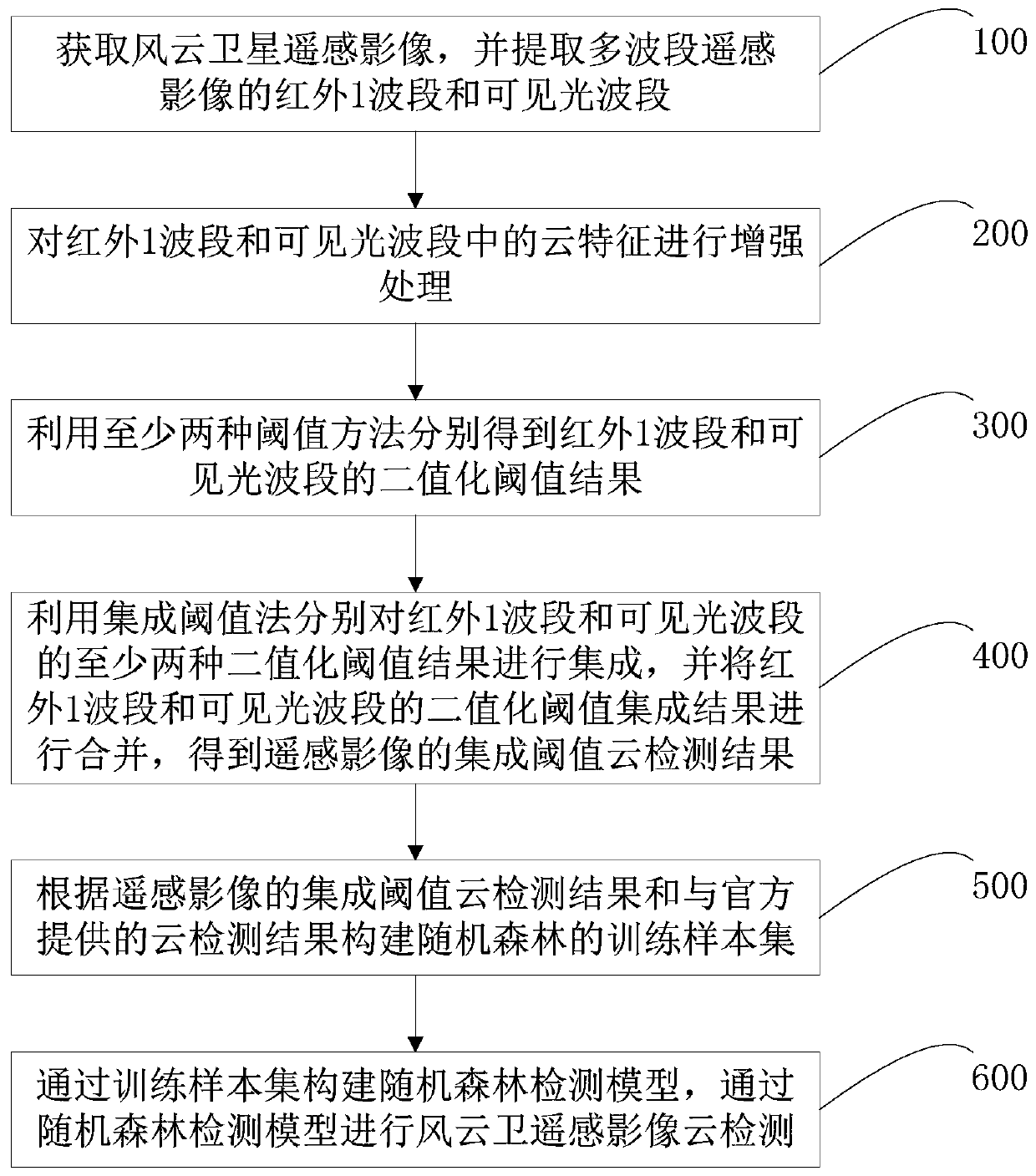
[0050] see figure 1 , is a flow chart of the cloud detection method for the Fengyun satellite remote sensing image according to the embodiment of the present application. The Fengyun satellite remote sensing image cloud detection method of the embodiment of the present application includes the following steps:

[0051] Step 100: Obtain the Fengyun satellite remote sensing image, and extract the infrared 1 band and visible light band of the Fengyun satellite remote sensing image;

[0052] Step 200: Enhance the cloud features in the infrared 1 band and the visible light band;

[0053] In ...


PUM


Abstract

The invention relates to a wind cloud satellite remote sensing image cloud detection method and system and electronic equipment. The method comprises the following steps: step a, extracting an infrared 1 wave band and a visible light wave band of a wind cloud satellite remote sensing image, and respectively obtaining at least two binarization threshold results of the infrared 1 wave band and the visible light wave band by utilizing at least two threshold methods; B, integrating at least two binarization threshold results of the infrared 1 wave band and the visible light wave band by using an integrated threshold method to obtain an integrated threshold cloud detection result of the remote sensing image; C, jointly selecting a training sample set of the random forest according to the integrated threshold cloud detection result and an official cloud detection result; and d, constructing a random forest detection model through the training sample set, and carrying out wind cloud satelliteremote sensing image cloud detection through the random forest detection model. According to the invention, the false detection and missing detection conditions of the cloud are effectively improved,and the utilization rate of the wind cloud satellite remote sensing image is improved.

Description

technical field [0001] The present application belongs to the technical field of remote sensing image cloud detection, and in particular relates to a cloud detection method, system and electronic equipment of Fengyun satellite remote sensing image cloud. Background technique [0002] With the continuous development of imaging technology, there are more and more channels for remote sensing image acquisition. In the process of wind and cloud remote sensing image acquisition, due to the influence of cloud and fog interference and other factors, the spectrum of the original object is distorted, which affects remote sensing products and image interpretation, and has a great impact on information extraction. Correctly separating cloudy pixels and cloudless pixels in remote sensing images has a significant impact on weather forecast, prevention of meteorological disasters, temperature inversion, rescue and monitoring of ecological environment. Therefore, in the process of using re...

Claims


Application Information

Patent Timeline
Patent Type & Authority Applications(China)
IPC IPC(8): G06K9/62G06K9/00G06K9/38
Inventor 刘军付华联陈劲松
Owner SHENZHEN INST OF ADVANCED TECH CHINESE ACAD OF SCI
Learn More