Adaptive UKF algorithm navigation method and system thereof

A navigation method and inertial navigation system technology, applied in directions such as navigation calculation tools, radio wave measurement systems, satellite radio beacon positioning systems, etc.

Active Publication Date: 2019-05-21
LANZHOU JIAOTONG UNIV +1
View PDF6 Cites 25 Cited by
  • Summary
  • Abstract
  • Description
  • Claims
  • Application Information

AI Technical Summary

Problems solved by technology

[0003] In order to solve the above technical problems, the present invention provides a navigation method and system of an adaptive UKF algorithm, which uses the global artificial bee colony algorithm to optimize the RBF neural network, and then cooperates with the noise to update the adaptive UKF algorithm with adjustable sampling window width , in order to improve the accuracy of integrated navigation and positioning when the satellite signal is normal, and train the neural network, and use the trained neural network to predict the output to suppress the divergence of position and speed errors when the satellite is out of lock

Method used


Image

  • Adaptive UKF algorithm navigation method and system thereof
  • Adaptive UKF algorithm navigation method and system thereof
  • Adaptive UKF algorithm navigation method and system thereof

Examples


Embodiment Construction

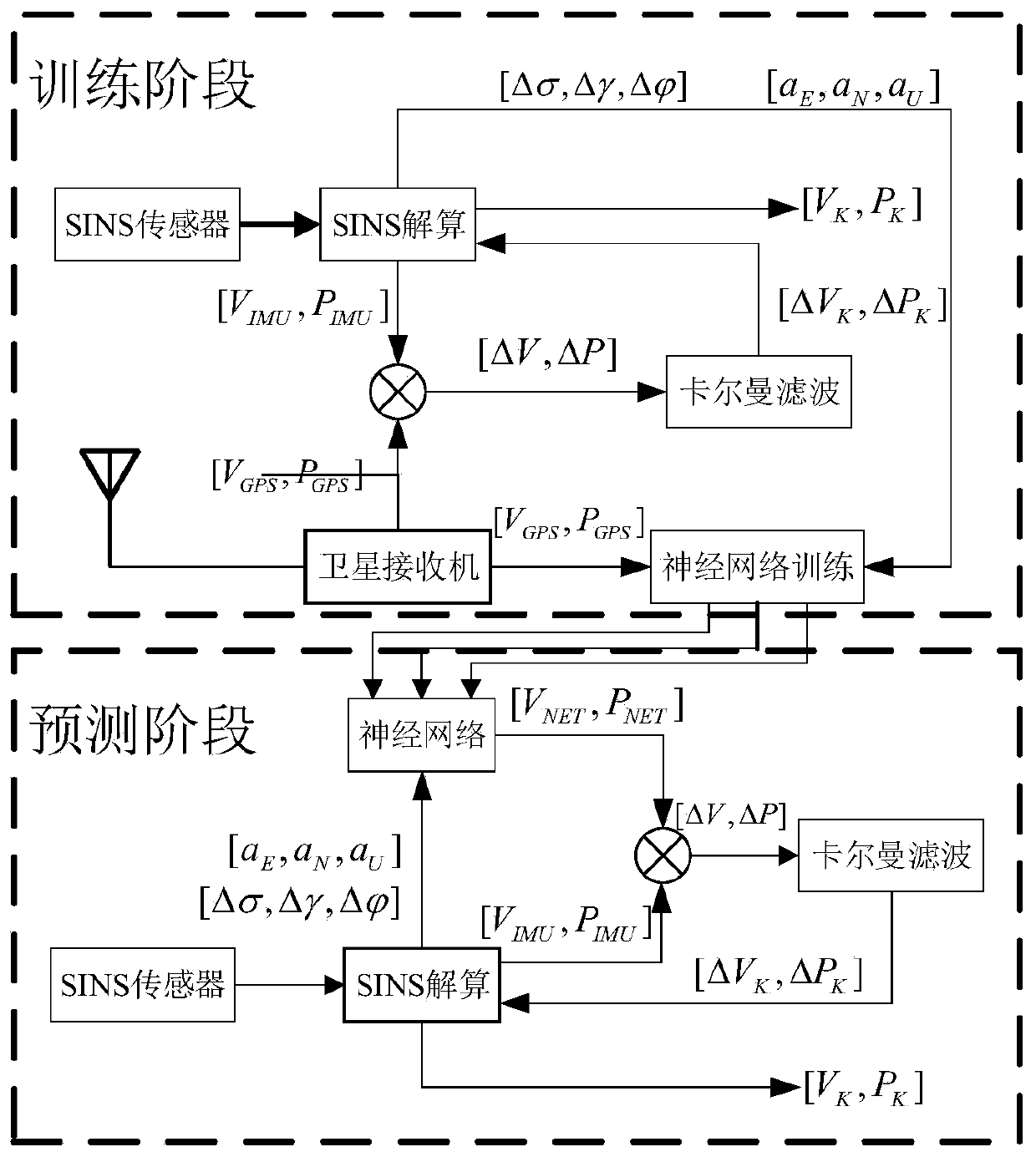
[0088] Such as Figure 3-4 As shown, the embodiment provides a navigation method of an adaptive UKF algorithm,

[0089] Step 1: Collect the raw data of the inertial sensor, including the three-axis acceleration value output by the accelerometer and the three-axis angular rate value output by the gyroscope;

[0090] Step 2: update the positioning information of the inertial navigation system, and calculate the eastward, northward, celestial velocity, pitch angle, and roll of the carrier in the northeast sky coordinate system according to the acceleration value and angular rate value output by the inertial measurement device and the initial value of the system state Angle, heading angle, and then calculate the longitude, latitude and height information;

[0091] Step 3: Search and collect GPS positioning information, including the current carrier latitude and longitude, altitude, and three-way speed in the northeast sky, and judge the reliability of the satellite signal accordi...


PUM


Abstract

The invention provides an adaptive UKF algorithm navigation method and a system thereof. The method comprises: inertial sensor raw data are collected; positioning information of an inertial navigationsystem is updated; GPS positioning information is searched and collected and the reliability of a satellite signal is determined; when the number of satellites is greater than 4 and the HDOP value isabout 1, a GPS / INS combined navigation mode is triggered; otherwise, a neural network prediction correction mode is triggered; compensation correction is carried out on the positioning information output by the inertial navigation system; an error covariance matrix is updated adaptively; a neural network training sample is stored and the nerve network structure parameters are trained and updatedand the like. According to the invention, the system noises of the UKF filter system are adjusted adaptively and the noise covariance matrix is measured under the condition that the satellite signal is normal, so that problems that the filtering precision reduction and divergence are caused by the unclear or inaccurate statistical characteristics of the system noise are solved.

Description

technical field [0001] The invention relates to the technical field of navigation, in particular to a navigation method and system of an adaptive UKF algorithm. Background technique [0002] The integrated navigation system based on MEMS inertial sensor devices and GPS (Global Position System) has the advantages of small size, low power consumption, high reliability and low price, so it is widely used in vehicle navigation and positioning, UAV flight control and navigation, etc. fields. However, limited by the low precision of the MEMS inertial device used in the strapdown inertial navigation system and the problem of error accumulation, only relying on inertial navigation when the satellite signal is lost or the signal is weak will cause the positioning error to diverge sharply, resulting in positioning failure . Experts and scholars at home and abroad have conducted research on this and put forward various solutions. The RBF (Radial Baisi Function) assisted AKF (Adaptiv...

Claims


Application Information

Patent Timeline
Patent Type & Authority Applications(China)
IPC IPC(8): G01C21/16G01C21/20G01S19/49
Inventor 陈光武程鉴皓杨菊花刘昊张琳婧
Owner LANZHOU JIAOTONG UNIV
Why Eureka
Try Eureka