System, method and device for measuring tilt amount of GNSS receiver and storage medium

A tilt measurement and receiver technology, applied in the field of navigation and positioning, can solve the problems of complex correction process, position information error, cumbersome correction, etc., and achieve the effect of improving the acquisition accuracy

Pending Publication Date: 2019-05-28
SHANGHAI HUACE NAVIGATION TECH
View PDF6 Cites 11 Cited by
  • Summary
  • Abstract
  • Description
  • Claims
  • Application Information

AI Technical Summary

Problems solved by technology

[0004] In the prior art, the electronic compass is used as the attitude acquisition device, but its accuracy is low, the calibration is cumbersome, and the reliability is poor. At the same time, there are certain errors in the position information obtained by the GNSS receiver due to factors such as its own structure and geographical environment. In addition, the magnetic force The magnetometer is easily affected by the environment, for example, by factors such as current or magnetic field, and the magnetometer must be calibrated before each use, and the calibration process is very complicated
However, the measurement method based on the spatial intersection theory is affected by the geometric structure of the spatial point distribution, especially in environments such as wall corners. The distribution of spatial points is limited, the geometric structure is poor, and the accuracy of the measurement points is unstable, which can only reach the decimeter level. Accuracy, and multiple spatial points need to be measured to complete the tilt measurement

Method used


Image

  • System, method and device for measuring tilt amount of GNSS receiver and storage medium
  • System, method and device for measuring tilt amount of GNSS receiver and storage medium
  • System, method and device for measuring tilt amount of GNSS receiver and storage medium

Examples


Embodiment 1

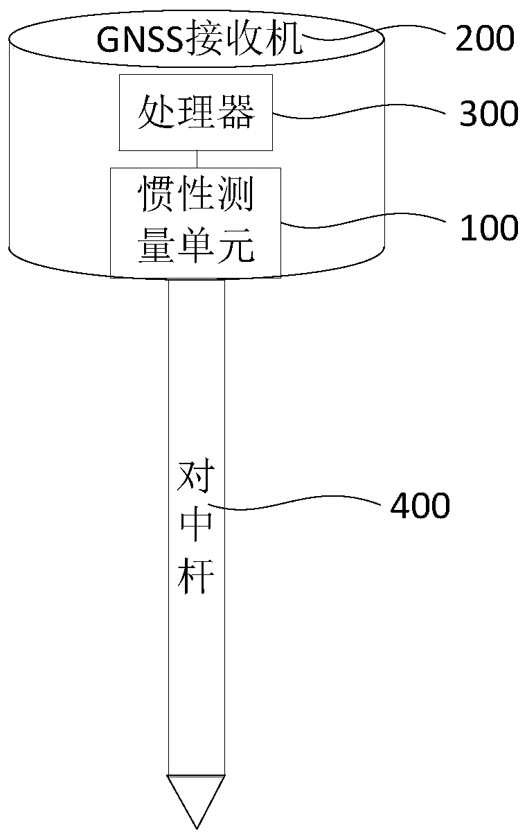
[0030] figure 1 A structural block diagram of a GNSS receiver tilt measurement system provided in Embodiment 1 of the present invention, the system includes: an inertial measurement unit 100, a GNSS receiver 200, a processor 300, and a centering rod 400, and the centering rod 400 is connected to The bottom of the GNSS receiver 200 is centered and directed to the ground.

[0031] The GNSS receiver 200 is configured to measure first position information of the antenna phase center of the GNSS receiver 200 and send it to the processor 400; the first position information includes first position coordinates and a first speed.

[0032] GNSS, which uses satellites to achieve multiple functions such as positioning, navigation, and monitoring. All existing satellite navigation systems, such as GPS and Beidou, belong to the category of GNSS; and GNSS receivers use GNSS technology to use To carry out long-term online monitoring of the displacement of the surface. When a small displaceme...

Embodiment 2

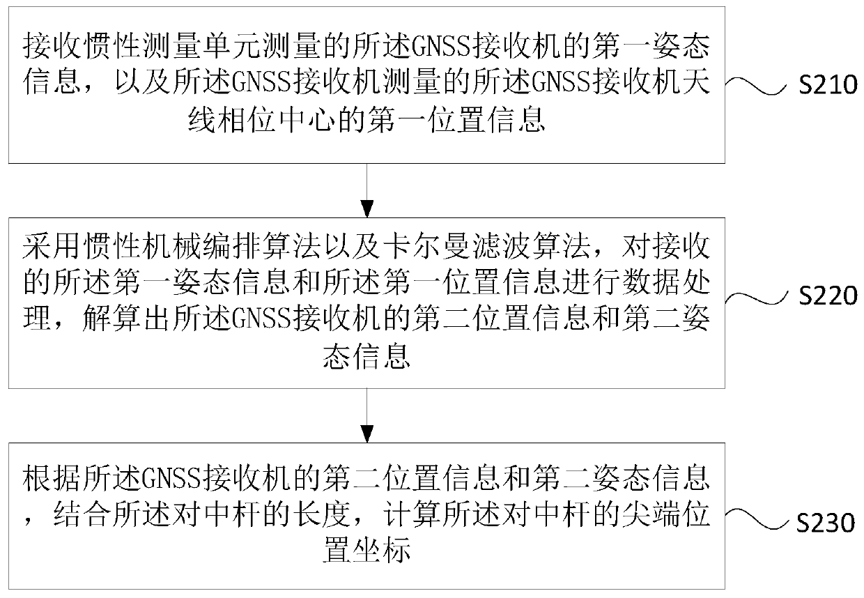
[0043] figure 2 A flow chart of a method for measuring the inclination of a GNSS receiver provided in Embodiment 2 of the present invention. This embodiment is applicable to the situation where an inertial measurement unit and a GNSS receiver are used to perform inclination measurement together. This method can be implemented by the GNSS receiver inclination measuring device is implemented, and this device can be realized by software and / or hardware, and generally can be integrated in the GNSS receiver inclination system as described in any embodiment of the present invention, typically, can be with program code The mode is integrated in the processor of the GNSS receiver tilting system, and the method in the embodiment of the present invention specifically includes the following steps:

[0044] S210. Receive first attitude information of the GNSS receiver measured by an inertial measurement unit, and first position information of an antenna phase center of the GNSS receiver ...

Embodiment 3

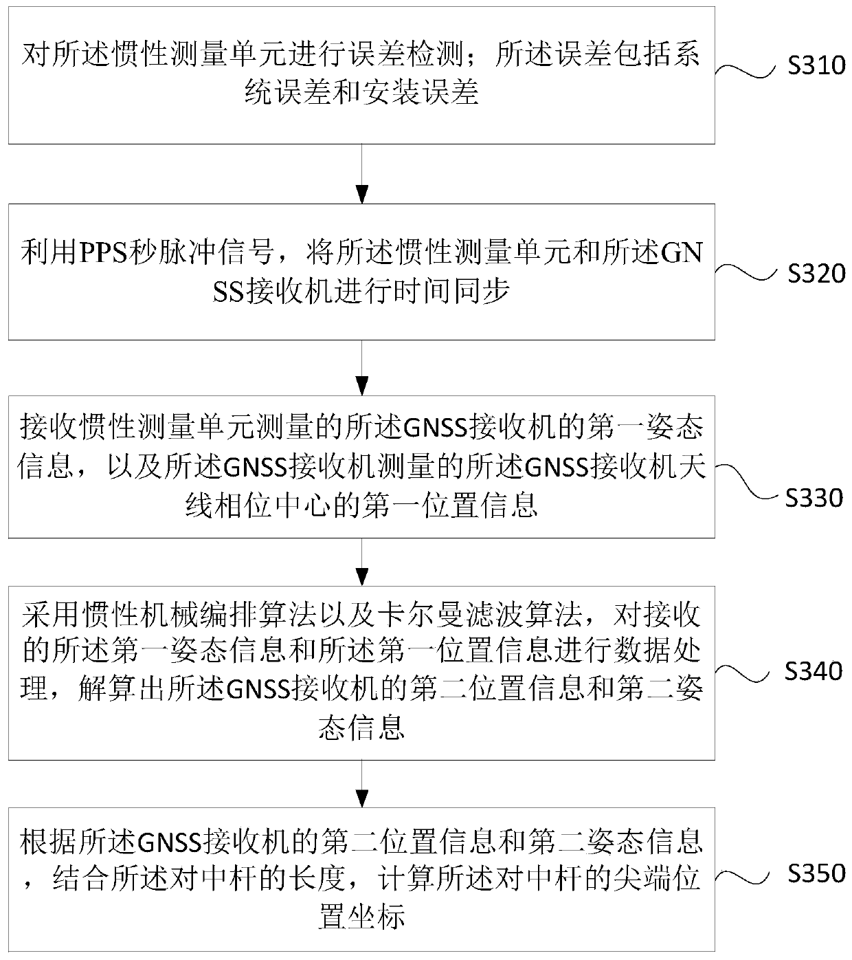
[0053] Figure 3A A flow chart of a GNSS receiver tilt measurement method provided by Embodiment 3 of the present invention. This embodiment is embodied on the basis of the above-mentioned embodiments. In this embodiment, the inertial measurement unit is installed on the GNSS receiver to perform Error detection, while the inertial measurement unit and the GNSS receiver are time-synchronized, the method of the embodiment of the invention specifically includes the following steps:

[0054] S310. Perform error detection on the inertial measurement unit; the error includes a system error and an installation error.

[0055] When the inertial measurement unit is installed in the GNSS receiver, due to various factors such as manual installation and structure, there must be installation errors; at the same time, the inertial measurement unit itself has a system error, which includes the zero bias of the gyroscope, It can also include the zero bias of the accelerometer and the scale f...


PUM


Abstract

The embodiment of the invention discloses a system, method and device for measuring tilt amount of a GNSS receiver, wherein the system comprises an inertial measurement unit, a GNSS receiver, a processor and a centering rod, wherein the inertial measurement unit is used for measuring first attitude information of the GNSS receiver; the GNSS receiver is used for measuring first position information; and the processor is used for calculating second position information and second attitude information according to received data by adopting an inertial navigation mechanical arrangement algorithm and a Kalman filtering algorithm. According to the technical scheme of the embodiment of the invention, the attitude information and the position information are respectively acquired by the inertial measurement unit and the GNSS receiver, the position, speed and attitude of the GNSS receiver are estimated by using the inertial navigation mechanical arrangement algorithm, and the estimation resultis corrected by using the Kalman filtering algorithm to calculate the measurement error feedback, so that the acquisition precision of the GNSS receiver is improved, and the dynamic tracking of the attitude, speed and position is achieved.

Description

technical field [0001] Embodiments of the present invention relate to the field of navigation and positioning, and in particular to a GNSS receiver tilt measurement system, method, device and storage medium. Background technique [0002] With the continuous advancement of science and technology, GNSS (Global Navigation Satellite System, Global Navigation Satellite System) receivers are widely used in various navigation and positioning equipment. As a position acquisition device, GNSS receivers can more accurately acquire the equipment under test. position information, and the emergence of tilt measurement technology has greatly improved the measurement accuracy and work efficiency of GNSS receivers. [0003] In order to enable the GNSS receiver to measure the tilt, an electronic compass is usually installed in the GNSS receiver for measurement. The electronic compass includes an accelerometer and a magnetometer. On this basis, some gyroscopes are also installed. According to...

Claims


Application Information

Patent Timeline
Patent Type & Authority Applications(China)
IPC IPC(8): G01S19/14G01S19/47G01S19/52G01S19/53
Inventor 邓海峰贾倩郑丹丹李刚张永乐梅松强台磊赵何芳
Owner SHANGHAI HUACE NAVIGATION TECH
Why Eureka
Try Eureka