Unmanned aerial vehicle (UAV) flight path planning method based on competitive deep learning network

A deep learning network and flight path technology, applied in the field of UAV flight path planning, can solve problems such as reducing the accuracy of UAV planning paths, and the safety and efficiency of UAV path planning being difficult to meet requirements.

Active Publication Date: 2019-06-11
BEIHANG UNIV
View PDF9 Cites 33 Cited by
  • Summary
  • Abstract
  • Description
  • Claims
  • Application Information

AI Technical Summary

Problems solved by technology

This reduces the accuracy of the drone's path planning
At the same time, due to some inherent defects in the reward setting in the Q-learning algorithm, the safety and efficiency of UAV path planning are difficult to meet the requirements

Method used


Image

  • Unmanned aerial vehicle (UAV) flight path planning method based on competitive deep learning network
  • Unmanned aerial vehicle (UAV) flight path planning method based on competitive deep learning network
  • Unmanned aerial vehicle (UAV) flight path planning method based on competitive deep learning network

Examples


Embodiment Construction

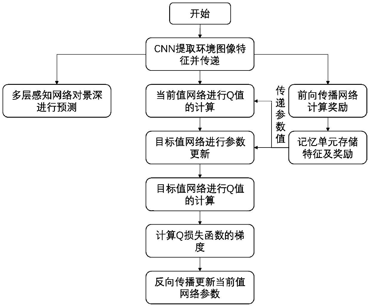
[0051] The present invention will be described in detail below in conjunction with the accompanying drawings and embodiments.

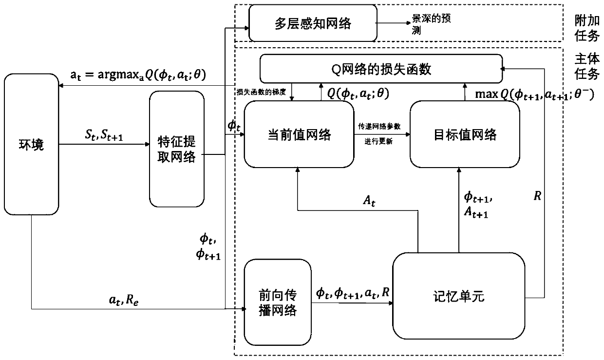
[0052] Such as figure 1 , 3 Shown, the present invention is concretely realized as follows:

[0053] In the first step, the camera on the UAV takes real-time shots of the environment and obtains images. It is stipulated that the camera captures the image in front of the drone. By shooting, the environment transfers image information to the feature extraction network.

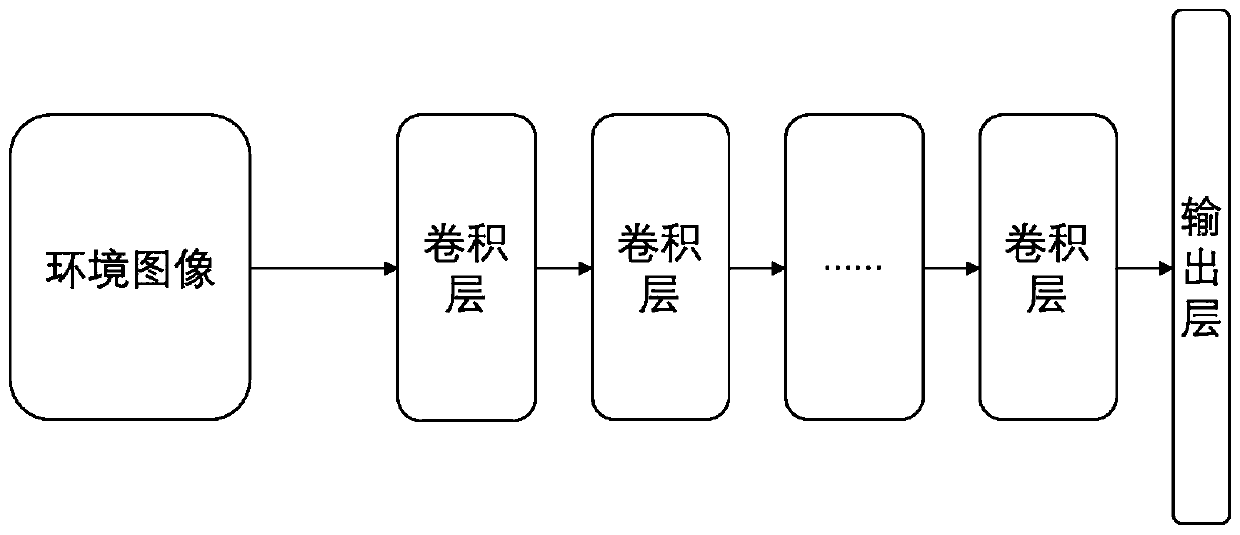
[0054] In the second step, the feature extraction network in the drone extracts feature information from the image. In the part of image processing, the main task is to complete the identification of visual positions, so in this part of the network, the present invention uses convolutional layers instead of pooling layers. Considering that the pooling layer performs element screening in some areas of the convolutional feature map, it is very likely to cause the loss of important p...


PUM


Abstract

The invention relates to a unmanned aerial vehicle (UAV) flight path planning method based on a competitive deep learning network. The method comprises the following steps: carrying out feature information extraction on real-time pictures photographed by a camera, so that a column of feature vectors are obtained; calculating each feature vector to obtain a state function value and a superiority function value, and combining the two values on a combination layer to obtain a state action function value; using the state action function value as an instant state action function value which cooperates with a target value network in construction of a loss function of the network and prediction of a next state, so that total rewards jointly formed by internal rewards and external rewards are obtained; carrying out depth-of-field prediction on the real-time pictures; carrying out calculation to obtain another state action function value; and calculating the gradient of the loss function and carrying out back propagation of the gradient to a current value network for network parameter updating.

Description

technical field [0001] The invention relates to a UAV flight path planning method based on a competitive deep learning network, which belongs to the technical field of aircraft. Background technique [0002] With the increasing congestion of ground traffic, more and more people are focusing their attention on the field of air traffic. Among them, UAV path planning is one of the most popular research directions in the field of air traffic. In general, path planning refers to the problem of finding the optimal path from the starting point to the end point under the constraints of the environmental space according to a certain evaluation system. But in the actual environment where UAVs work, it is difficult for the aircraft to obtain global information about the environment. Therefore, UAVs often face obstacles that suddenly appear on the path during flight, and respond to them in an emergency. These demanding requirements undoubtedly bring great challenges to the subject of...

Claims


Application Information

Patent Timeline
Patent Type & Authority Applications(China)
IPC IPC(8): G01C21/20G05D1/10
Inventor 曹先彬杜文博朱熙郭通张晋通李宇萌
Owner BEIHANG UNIV
Why Eureka
Try Eureka