Triangular elevation measuring method applied in highways in mountain areas
A triangular elevation and highway technology, applied in the field of measurement, can solve the problems of large elevation difference, low efficiency of elevation control measurement, complex terrain, etc., achieve high measurement efficiency, eliminate the effect of atmospheric refraction and earth curvature
- Summary
- Abstract
- Description
- Claims
- Application Information
AI Technical Summary
Problems solved by technology
Method used
Image


Examples
Embodiment 1
[0027] In this case, combined with the third-class leveling project of Shanxi Jingxing Expressway, two measuring robots are used to carry out the intermediate method and the method of facing triangular elevation measurement at the same time, so as to solve the problem of complex terrain, large elevation difference, and elevation control measurement in mountainous expressway construction elevation control measurement. Low efficiency problem. To improve the measurement accuracy of mountain elevation control and field measurement efficiency.
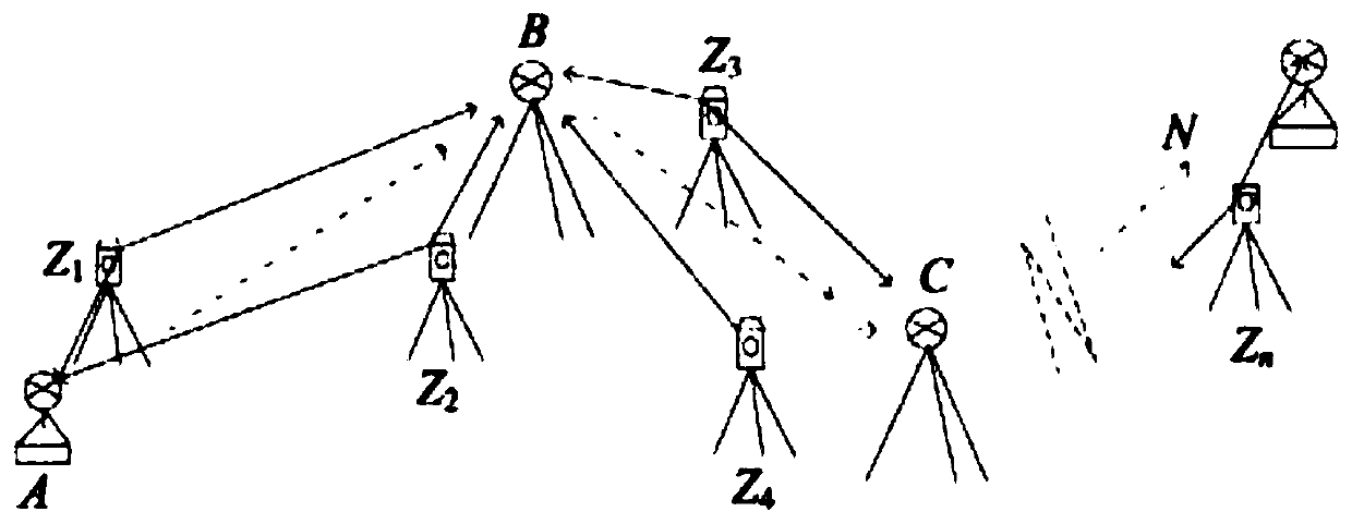
[0028] Step one, set up a triangular elevation measuring instrument
[0029] Including total station, prism, base, A and N are special bases with leveling device and fixed prism height placed on the level point, Z1, Z2,...Zn are total stations placed on a tripod, B, C,...M is a prism placed on a tripod and an ordinary base. The total station is set up at any position between the two prisms by the free station method, and the total station and p...
Embodiment 2
[0037] Triangular elevation measurement verification
[0038] 1 data collection
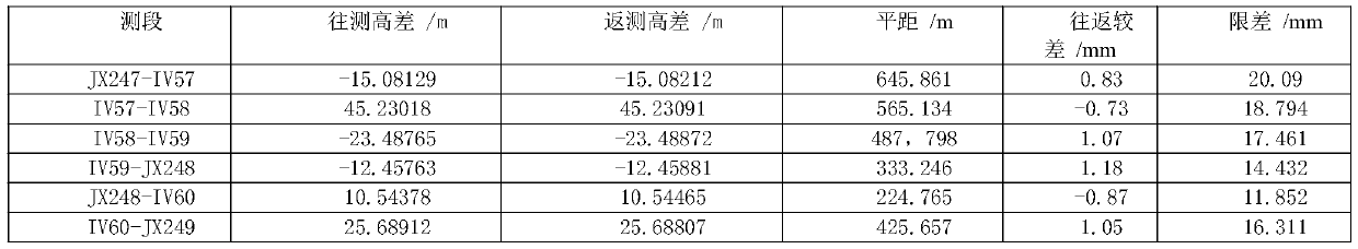
[0039] Taking the height difference measurement between the benchmarking points JX247-JX249 of the Yellow River Bridge on Jingxing Expressway as an example, using 2 TS15s, equipped with an on-board automatic measurement and recording program, the triangle elevation between the two benchmarking points is measured by the intermediate method. The height difference can obtain the height difference of each measurement section and the height difference between the two standard points, and compare it with the level height difference. Refer to Table 1 for the technical requirements of field triangle elevation measurement.
[0040] Table 1 Technical requirements for optical distance measurement and triangulation elevation measurement
[0041] grade Side length / m Number of rounds during distance measurement Vertical angle measurement rounds Poor index difference / (″) The vertical angle between measurement rou...
PUM
 Abstract
Description
Claims
Application Information
 - R&D
- Intellectual Property
- Life Sciences
- Materials
- Tech Scout
- Unparalleled Data Quality
- Higher Quality Content
- 60% Fewer Hallucinations
Browse by: Latest US Patents, China's latest patents, Technical Efficacy Thesaurus, Application Domain, Technology Topic, Popular Technical Reports.
© 2025 PatSnap. All rights reserved.Legal|Privacy policy|Modern Slavery Act Transparency Statement|Sitemap|About US| Contact US: help@patsnap.com