

Multi-source data standardization processing method integrated with engineering geological achievements
A technology of standardized processing and engineering geology, applied in the intersection of geographic information system and engineering geology, can solve the problems of lack of emerging data support such as urban 3D model, scattered data storage, inconsistent standards, etc., to achieve fast data collection and collation, integrated The effect of improving the management level with all kinds of data
- Summary
- Abstract
- Description
- Claims
- Application Information
AI Technical Summary
Problems solved by technology
Method used
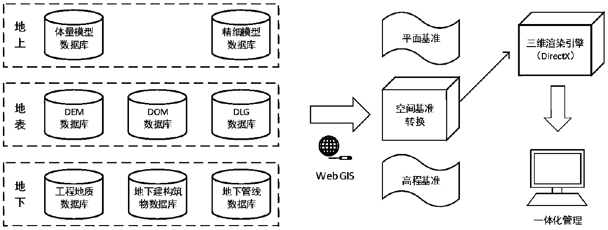
Image


Examples
Embodiment Construction
[0052] The present invention is described in further detail now in conjunction with accompanying drawing.
[0053] A multi-source data standardized processing method for integrating engineering geological results, comprising the following steps:
[0054] Step 1. Establish a standard stratigraphic table: comprehensively analyze the geological background of the region and surrounding cities, select representative drilling data, reveal through typical geological sections, divide the main sequence and sub-sequence, and form a cross-regional compatible standard stratum surface. The specific contents are:
[0055] 1) Analyze the geological situation: analyze the natural geography, topography, bedrock geology, Quaternary geology, hydrogeology, engineering geology and other aspects of the region and the surrounding major cities, and provide scientific and reliable information for the next work direction.
[0056] 2) Draw a typical geological section: select drilling data with suffici...
PUM
 Abstract
Description
Claims
Application Information