Shortest path routing calculation method for underwater wireless sensor network

A technology of wireless sensor and shortest path, which is applied in the field of shortest path routing calculation of underwater wireless sensor network, which can solve the problems of unusable routing algorithm and inability to obtain the global position information of underwater wireless sensor network, so as to reduce the data packet loss rate, Improve the protection mechanism and reduce the effect of energy consumption

Pending Publication Date: 2019-08-27
HUNAN INST OF TECH
View PDF0 Cites 1 Cited by
  • Summary
  • Abstract
  • Description
  • Claims
  • Application Information

AI Technical Summary

Problems solved by technology

[0003] Therefore, the routing algorithm used in the terrestrial wireless sensor network cannot be directly used in the underwater wireless sensor network. The shortest path routing algorithm for wireless sensor networks, bu

Method used


Image

  • Shortest path routing calculation method for underwater wireless sensor network
  • Shortest path routing calculation method for underwater wireless sensor network
  • Shortest path routing calculation method for underwater wireless sensor network

Examples


Embodiment 1

[0035] A method for calculating the shortest path route of an underwater wireless sensor network, specifically comprising the following steps:

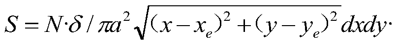
[0036] Step 1. Select the node closest to the node as the cache node, divide the monitoring environment into a Voronoi diagram, and the cache node is the center of each Voronoi unit. After the data passes through multiple nodes in the Voronoi unit, it is forwarded to the sink node through the cache node. Among them, when the Voronoi unit is A, the center coordinates are (x e ,y e ), the path length limit formula for data to be transmitted from nodes in A to cache nodes is:

[0037]

[0038] Among them, N is the total number of nodes, a is the radius of the monitoring area, and the distribution density of nodes is N / πa 2 ;

[0039] Each Voronoi space is equal in size, and the radius of each space is

[0040] Step 2, set the number of cache nodes as i, and obtain the path for data in a single unit to be transmitted to the cache...

Embodiment 2

[0059] On the basis of the above embodiments, further, the simulation arranges 5000 nodes in a circular monitoring area with a radius of 1000m, and each node transmits data to the cache nodes in the respective Voronoi units, and finally the cache nodes compress the data and transmit to the Sink node;

[0060] Select the node closest to the node as the cache node, divide the monitoring environment into a Voronoi diagram, and the cache node is the center of each Voronoi unit. After passing through multiple nodes in the Voronoi unit, the data is forwarded to the sink node through the cache node. Among them, the Voronoi When the unit is A, the center coordinate is (x e ,y e ), the path length limit formula for data to be transmitted from nodes in A to cache nodes is:

[0061]

[0062] Among them, N is the total number of nodes, a is the radius of the monitoring area, and the distribution density of nodes is N / πa 2 ;

[0063] Each Voronoi space is equal in size, and the radi...

Embodiment 3

[0079] On the basis of the above embodiments, further, the number of retransmissions in the single-path routing mechanism is equal to the total number of data transmissions in all paths in the multi-path routing;

[0080] Through the transmission path length of the data in the Voronoi unit, the energy consumption model of the underwater sensor node is established, and the underwater energy loss is calculated;

[0081] Transfer the data of i cache nodes to the sink node, and calculate the energy consumption value of lbit transmission in the entire monitoring area, obtain the minimum unit of energy consumption value, mark the number of cache nodes corresponding to the minimum energy consumption value separately, and set it as the center of the Voronoi unit;

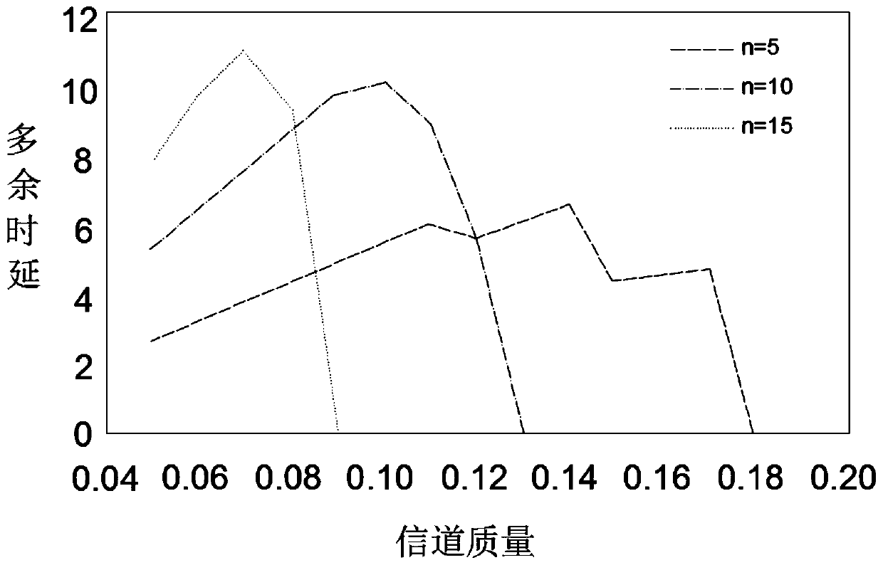
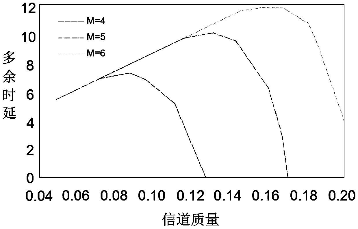
[0082] Establish a multi-path routing mechanism model. In a multi-path network structure, data completes n hops in the cache node and reaches the sink node, and the data packet is transmitted in a multi-path route;

[0083...


PUM


Abstract

The invention discloses a shortest path routing calculation method for an underwater wireless sensor network. The invention specifically relates to the technical field of wireless sensor networks. Themethod specifically comprises the following steps of: selecting a node closest to the node as a cache node, dividing the monitoring environment into a Voronoi diagram; wherein the cache node is usedas the center of each Voronoi unit; forwarding the data passing through a plurality of nodes in the Voronoi unit to the sink node through the cache node; wherein when the Voronoi unit is A, the central coordinate is (xe, ye); path length limiting formula for transmitting data to cache node through node in A is shown in the specification. According to the method, the underwater network time delay and the data packet loss rate are greatly reduced, the energy consumption is greatly reduced, the determination and selection of underwater routing nodes are realized, the shortest path suitable for the underwater wireless sensor network is obtained, and the life cycle of the whole wireless network is prolonged.

Description

technical field [0001] The invention relates to the technical field of wireless sensor networks, and more specifically, the invention relates to a method for calculating the shortest path route of an underwater wireless sensor network. Background technique [0002] Underwater wireless sensor networks are widely used in underwater environment monitoring, earthquake detection, resource discovery and other fields. Radio signals and optical signals are seriously absorbed in underwater transmission. The receiving sensor nodes on the water surface are equipped with radio modulators and underwater acoustic modulation. The radio modulator is used to modulate the communication from the receiving sensor node to the data center, and the underwater acoustic modulator is responsible for the communication from the underwater sensor node to the receiving sensor node. Since the underwater sensor nodes and the receiving sensor nodes move with the movement of the water flow, the positions of ...

Claims


Application Information

Patent Timeline
IPC IPC(8): H04W24/02H04W24/06H04W40/02H04W40/22H04W84/18H04B13/02
CPCH04B13/02H04W24/02H04W24/06H04W40/02H04W40/22H04W84/18Y02D30/70
Inventor 罗丹霞
Owner HUNAN INST OF TECH
Why Eureka
Try Eureka