Available land resource analysis system based on high-resolution satellite remote sensing data

A technology of satellite remote sensing data and land resources, applied in the field of land analysis system, can solve problems such as large amount of data, and achieve the effect of enhancing identification ability

Active Publication Date: 2019-08-30
CHINA UNIV OF GEOSCIENCES (BEIJING)
View PDF2 Cites 6 Cited by
  • Summary
  • Abstract
  • Description
  • Claims
  • Application Information

AI Technical Summary

Problems solved by technology

[0005] Due to the large amount of data to be processed by satellite remote sensing, usually only computer identification and analysis is used, and it is impossible to compare the actual situation one by one. Therefore, the existing remote sensing systems for the above phenomena have major defects

Method used


Image

  • Available land resource analysis system based on high-resolution satellite remote sensing data
  • Available land resource analysis system based on high-resolution satellite remote sensing data
  • Available land resource analysis system based on high-resolution satellite remote sensing data

Examples


Embodiment 1

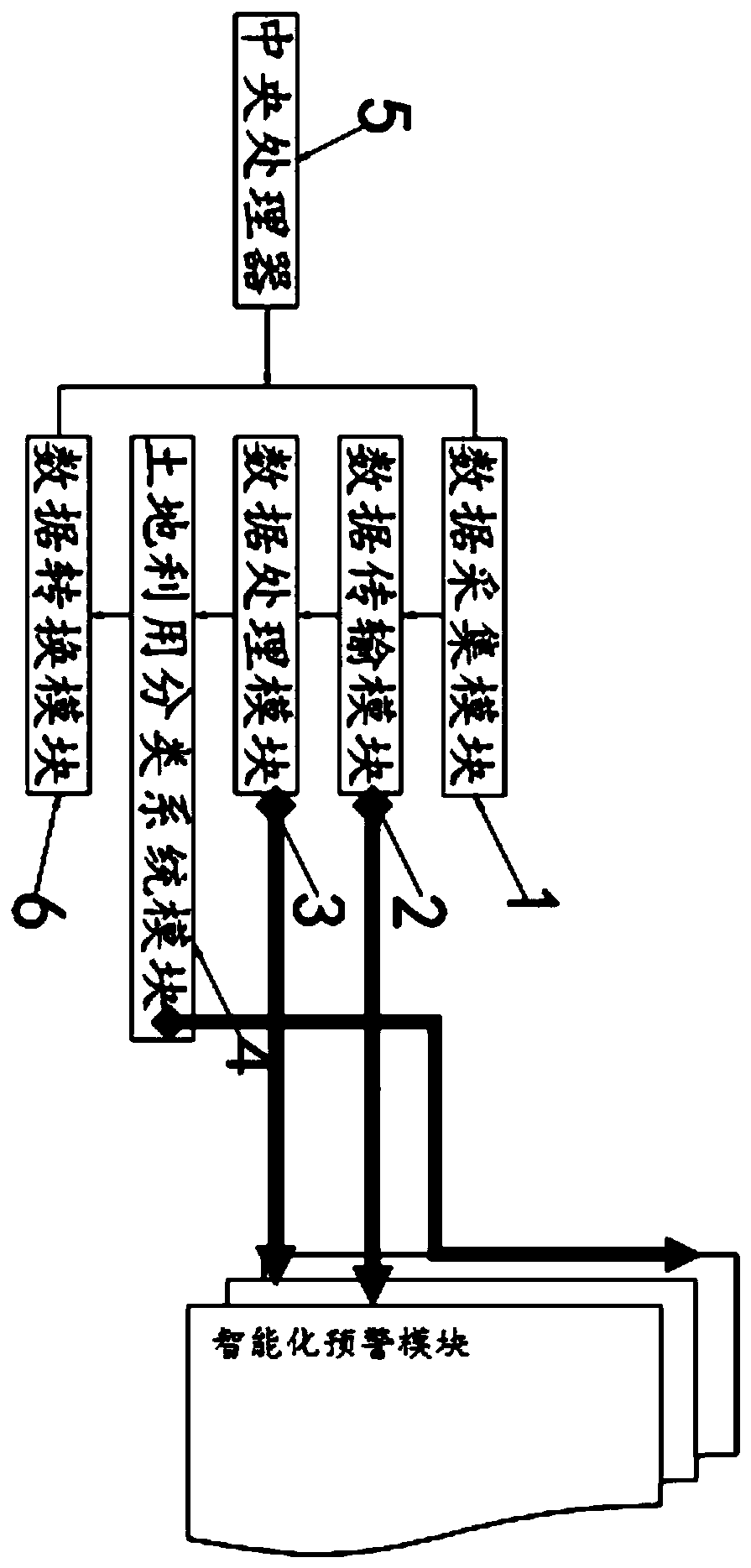
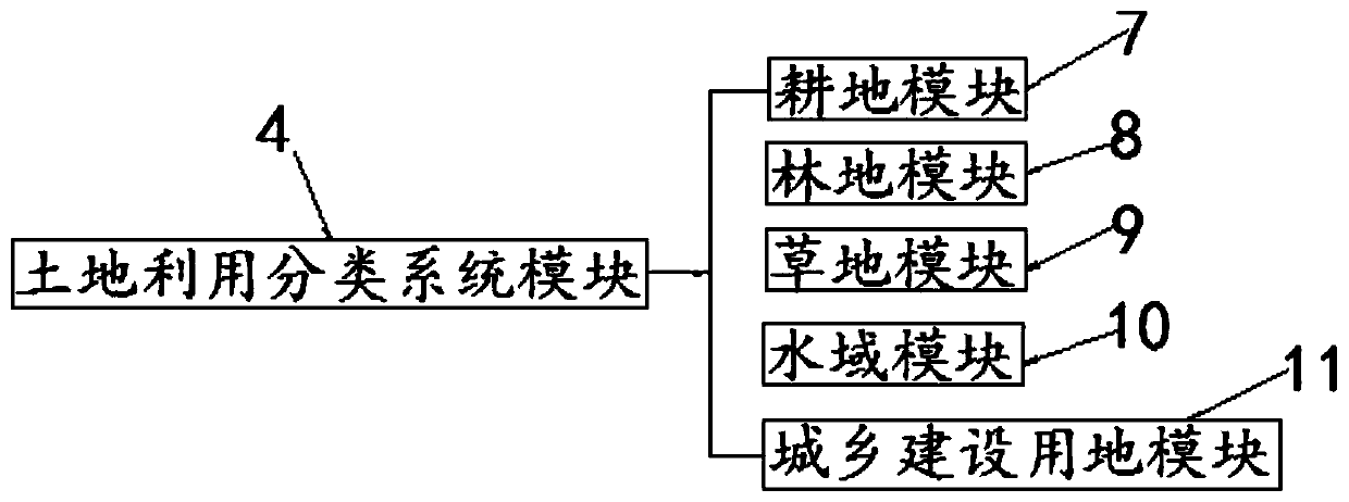
[0032] Example 1, such as Figure 1 to Figure 3As shown, the present invention provides a kind of available land resources analysis system based on high-resolution satellite remote sensing data, including data collection module 1, data transmission module 2, data processing module 3, land use classification system module 4, central processing unit 5 And data conversion module 6, described data acquisition module 1, data transmission module 2, data processing module 3, land use classification system module 4 and data conversion module 6 are all connected with described central processing unit 5, and described data acquisition module The output end of 1 is connected to the input end of the data transmission module 2, the output end of the data transmission module 2 is connected to the input end of the data processing module 3, and the output end of the data processing module 3 is connected to the land Utilize the input end of classification system module 4 to be connected, the o...

Embodiment 2

[0043] Embodiment 2, the data acquisition module 1 is used to acquire remote sensing image raster data and basic data of land spatial configuration.

Embodiment 3

[0044] Embodiment 3, the data processing module 3 refers to feature extraction, remote sensing scale selection and remote sensing image classification to remote sensing images, remote sensing image feature extraction refers to the extraction of spectrum, texture and shape features, the selection of the remote sensing scale Including the local variance method and variation function method, the methods of remote sensing image classification include methods based on statistical analysis and methods based on multi-source data fusion.


PUM


Abstract

The invention belongs to the field of land analysis systems. The invention, and particularly relates to an available land resource analysis system based on high-resolution satellite remote sensing data. The system comprises a data acquisition module, a data transmission module, a data processing module, an intelligent early warning module, a land utilization classification system module, a centralprocessing unit and a data conversion module, and the data acquisition module, the data transmission module, the data processing module, the land utilization classification system module and the dataconversion module are all connected with the central processing unit. And the intelligent early warning module is respectively in bidirectional connection with the data transmission module, the dataprocessing module and the land utilization classification system module, and comprises an intelligent image recognition and analysis module and a threshold judgment module. By using the system provided by the invention, the actual land type in the remote sensing image data can be intelligently identified, and the phenomenon of artificially covering the actual land utilization type is judged, so that the occurrence of errors is avoided.

Description

technical field [0001] The invention belongs to the field of land analysis systems, in particular to an available land resource analysis system based on high-resolution satellite remote sensing data. Background technique [0002] The survey methods used in traditional land use surveys are field surveys, measurements, and visual judgment and control, which are relatively random and cannot guarantee precision and accuracy. Using this survey method has great limitations. It takes a lot of manpower, material resources, financial resources and time to complete a survey task for a long period of time, and it is difficult to guarantee the accuracy and currentness of the final results. For large-scale and overall survey tasks, this survey method cannot Done successfully. [0003] Due to the development of computer technology and remote sensing technology, satellite remote sensing survey has gradually replaced the above survey methods. The current situation and real-time characteri...

Claims


Application Information

Patent Timeline
IPC IPC(8): G06Q10/06G06Q50/26
CPCG06Q10/063G06Q50/26
Inventor 郭笑尘邢廷炎
Owner CHINA UNIV OF GEOSCIENCES (BEIJING)
Why Eureka
Try Eureka