Method and system for evaluating ecological influence of development and construction projects in natural protection area
A technology for nature reserves and construction projects, applied in the ecological impact assessment method and system field of development and construction projects in nature reserves, can solve the threat of species and ecosystems, the protection of biodiversity in threat-affected areas, and the ecological damage of nature reserves And other issues
- Summary
- Abstract
- Description
- Claims
- Application Information
AI Technical Summary
Problems solved by technology
Method used
Image
Examples
Embodiment 1
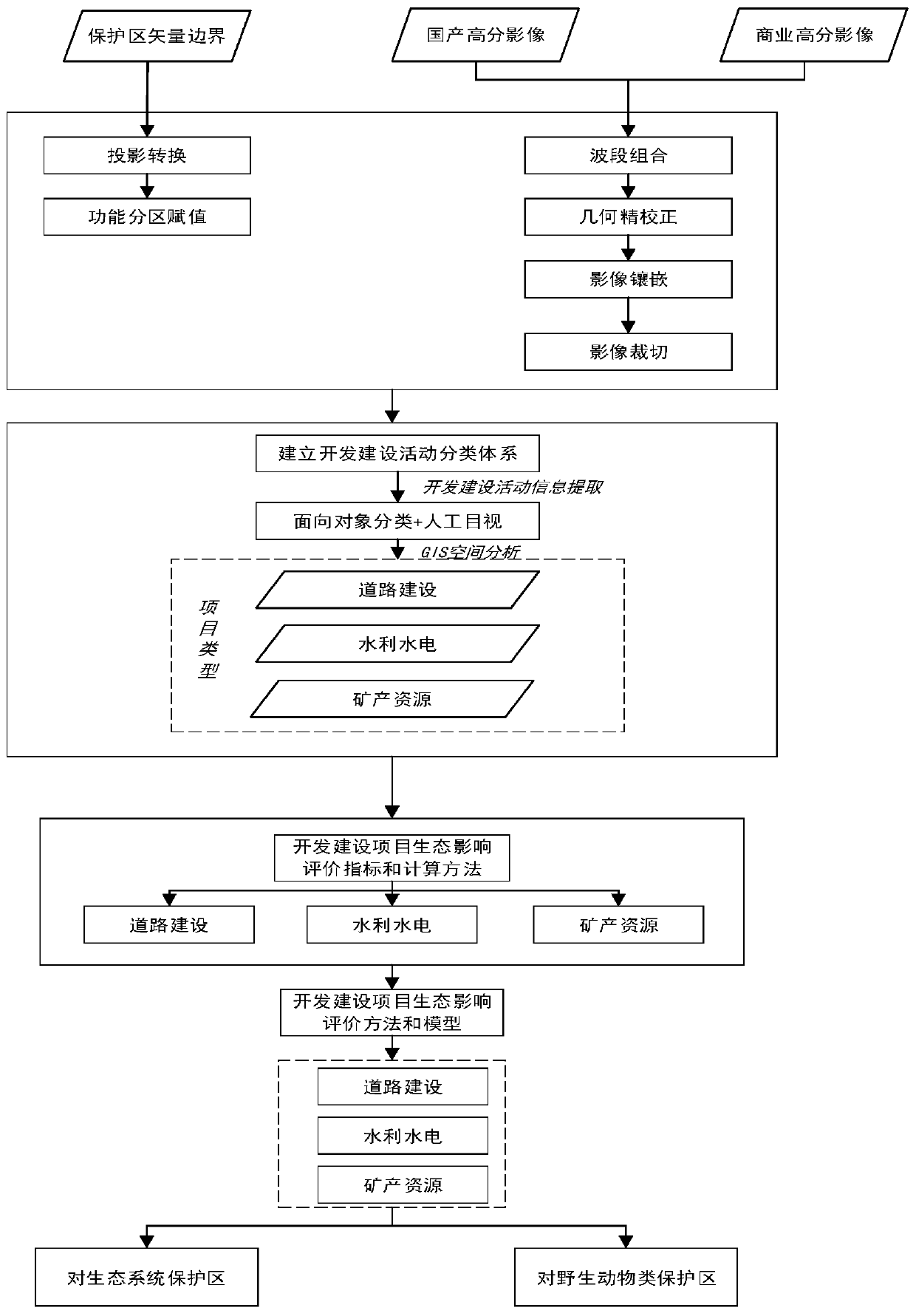
[0134] Embodiment 1 of the present invention discloses a method for evaluating the ecological impact of a development and construction project in a nature reserve, such as figure 1 shown.
[0135] (1) Remote sensing identification method for nature reserve construction projects
[0136] The object-oriented classification method is based on the spectral and shape characteristics of remote sensing images, setting appropriate segmentation scale, spectral heterogeneity, shape heterogeneity and other parameters, segmenting the image, obtaining homogeneous objects, and then comprehensively analyzing the objects according to the classification objectives The spectrum, shape, texture and other characteristics of the object are classified and extracted. It is mainly divided into the following four steps:
[0137] 1) Multi-scale segmentation
[0138] Multi-scale segmentation essentially uses the least heterogeneity-based merging algorithm (FNEA algorithm) to segment the image into mu...
Embodiment 2
[0382] Embodiment 2 of the present invention discloses an ecological impact evaluation system for development and construction projects of nature reserves, including a remote sensing identification subsystem, a project extraction subsystem, an ecosystem protection area impact evaluation subsystem, and a wild animal protection area impact evaluation subsystem; Figure 9 shown.
[0383] Among them, the remote sensing identification subsystem is used to obtain remote sensing images; the project extraction subsystem includes: multi-scale segmentation module, information extraction module and protected area type judgment module; multi-scale segmentation module is used for multi-scale segmentation of remote sensing identification images; The information extraction module is used to extract the evaluation index parameters; the protection area type judgment module is used to judge the protection area type of the impact area to be evaluated; the impact evaluation subsystem of the ecosys...
PUM
 Abstract
Description
Claims
Application Information
 - R&D
- Intellectual Property
- Life Sciences
- Materials
- Tech Scout
- Unparalleled Data Quality
- Higher Quality Content
- 60% Fewer Hallucinations
Browse by: Latest US Patents, China's latest patents, Technical Efficacy Thesaurus, Application Domain, Technology Topic, Popular Technical Reports.
© 2025 PatSnap. All rights reserved.Legal|Privacy policy|Modern Slavery Act Transparency Statement|Sitemap|About US| Contact US: help@patsnap.com


