Weather radar spatial interpolation method

A technology of weather radar and spatial interpolation, which is applied in the field of weather radar spatial interpolation and weather radar basic reflectivity factor spatial interpolation, which can solve problems that affect the quality control effect and are difficult to classify and judge

Active Publication Date: 2019-09-20
NANJING UNIV OF INFORMATION SCI & TECH
View PDF4 Cites 3 Cited by
  • Summary
  • Abstract
  • Description
  • Claims
  • Application Information

AI Technical Summary

Problems solved by technology

For example, Kessinger et al. proposed a radar echo classification algorithm based on fuzzy logic. Under certain conditions, the algorithm can effectively classify echoes and remove abnormal echoes and ground clutter. When waves exist at the same time, it is often difficult to accurately classify and judge. For details, see reference [1]
Zhang et al. proposed a quality control algorithm based on the analysis of the three-dimensional structure of the albedo data. The algorithm is relatively simple and highly implementable, but it is sometimes difficult to distinguish the clutter at long distances from the echo of shallow stratiform cloud precipitation. come, thus affecting the effect of quality control, see reference [2] for details

Method used


Image

  • Weather radar spatial interpolation method
  • Weather radar spatial interpolation method
  • Weather radar spatial interpolation method

Examples


Embodiment 1

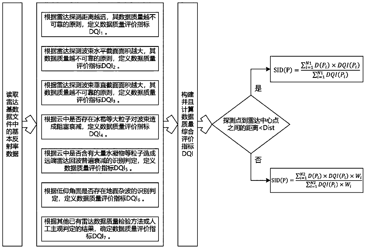
[0059] Such as figure 1 Shown, a kind of weather radar space interpolation method provided by the present invention, this method comprises the following steps:

[0060] 1) Read a basic weather radar data file, and extract the basic reflectivity information from the file, where the basic reflectivity of any detection point is recorded as in, Represents the elevation angle of radar detection, γ represents the distance from the radar detection point to the center of the radar, that is, the number of distance bins, and ω represents the azimuth angle of radar detection;

[0061] 2) Define the first radar data quality evaluation index DQI 1 :

[0062]

[0063] Among them, ds represents the distance from the current detection point to the radar center, T_0 and T_ds are both empirical thresholds, T_0∈[0.01, 0.1], T_ds∈[1km, 500km];

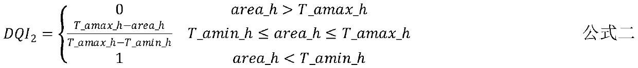
[0064] Define the second radar data quality evaluation index DQI 2 :

[0065]

[0066] Among them, area_h represents the horizontal cross-s...


PUM


Abstract

The invention discloses a weather radar spatial interpolation method. The method takes the quality of radar data as an evaluation index of weighting during weighted superposition calculation; and for detection points far away from the center of a radar, and through the consideration of influences of the distances between the adjacent detection points on interpolation calculation, improvement and optimization can be performed on a spatial interpolation method from space distances and data quality. The implementing of the method can reduce the adverse influences on spatial interpolation calculation caused by abnormal detection points, so that the basic reflectance data after spatial interpolation can be closer to the actual situations of the atmosphere, and therefore, more reliable and accurate basic data can be provided for weather forecast and early warning services such as short-impending precipitation forecast, strong wind forecast and severe convection weather forecast, and the accuracy of weather forecast and early warning can be achieved.

Description

technical field [0001] The invention relates to a weather radar space interpolation method, in particular to a weather radar basic reflectivity factor space interpolation method based on a data quality comprehensive evaluation index, and belongs to the field of atmospheric detection in geographical science. Background technique [0002] Weather radar is one of the important means to detect atmospheric water vapor conditions. It has the characteristics of strong real-time detection and high-altitude resolution. It has been playing an indispensable role in the monitoring, diagnosis, forecasting and warning of sudden and disastrous weather. important role. PPI (Plan Position Indicator) is one of the most commonly used primary products in weather radar detection data. The Chinese interpretation of PPI means "plane position indicator product". Echo data, also known as the basic reflectivity factor, is presented in the form of polar coordinates with the radar as the center point ...

Claims


Application Information

Patent Timeline
IPC IPC(8): G01S13/95G01S7/41
CPCG01S13/958G01S7/418Y02A90/10
Inventor 王兴曾康毛雅萍常泽婷钱代丽樊仲欣
Owner NANJING UNIV OF INFORMATION SCI & TECH
Why Eureka
Try Eureka