Method for monitoring irrigation area of irrigation area based on high-resolution satellite data

A technology for satellite data and irrigation area, applied in image data processing, image analysis, instruments, etc., can solve problems such as insufficiency, lack of spatial information in agricultural statistics, and lack of spatial resolution and accuracy in irrigation remote sensing products, to reduce errors, Good adaptability to changes and the effect of improving accuracy

Active Publication Date: 2019-09-27
CHINA INST OF WATER RESOURCES & HYDROPOWER RES
View PDF8 Cites 8 Cited by
  • Summary
  • Abstract
  • Description
  • Claims
  • Application Information

AI Technical Summary

Problems solved by technology

[0005] The purpose of the present invention is to provide a method based on high-resolution satellite data to monitor the irrigation area of ​​irrigation areas, to solve the lack of spatial information in agricultural statistics in the prior ar...

Method used


Image

  • Method for monitoring irrigation area of irrigation area based on high-resolution satellite data
  • Method for monitoring irrigation area of irrigation area based on high-resolution satellite data
  • Method for monitoring irrigation area of irrigation area based on high-resolution satellite data

Examples


Embodiment Construction

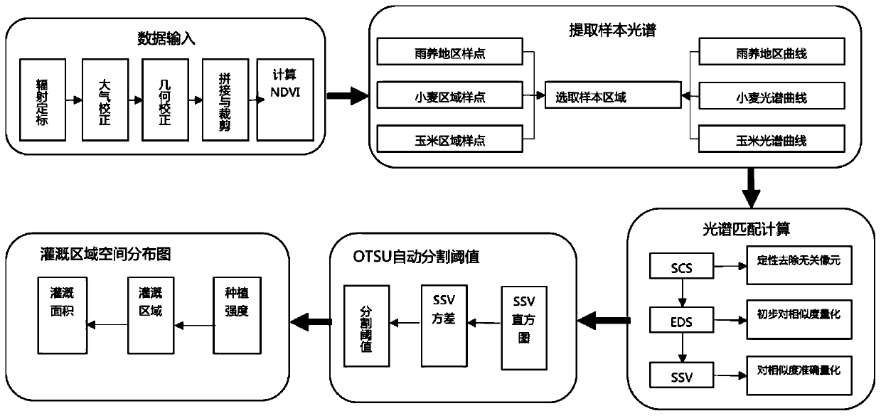
[0047] The technical solutions of the present invention will be further described below in conjunction with the accompanying drawings and embodiments.

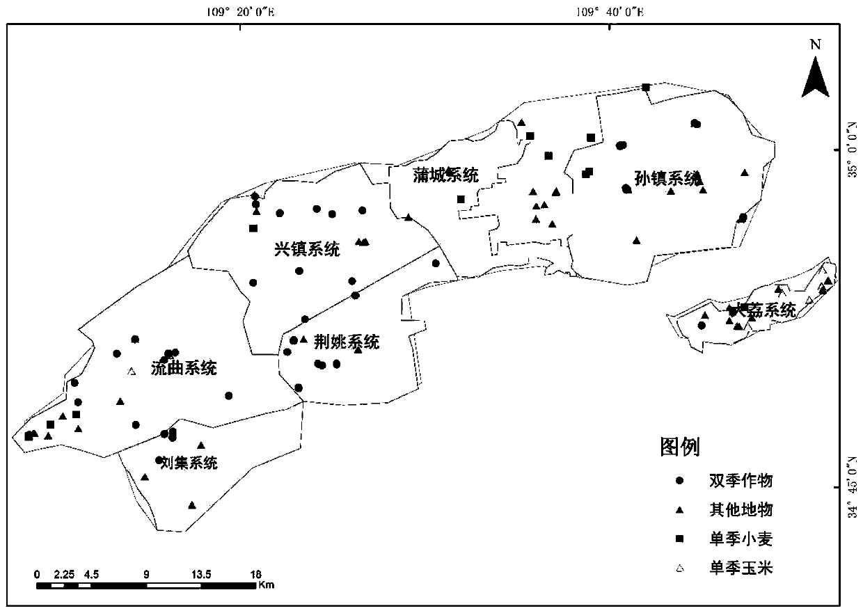
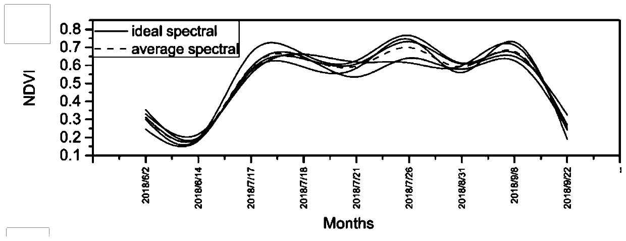
[0048] In the embodiment of the present invention, the typical canal irrigation area in the semi-arid area of ​​Northwest my country, that is, the Donglei second-stage pumping yellow irrigation area, was selected as the research area, and the remote sensing identification and extraction of the irrigated area of ​​wheat and corn in 2018 was carried out, and the accuracy of field sampling was verified. The results were overall The accuracy was 88.27% (Kappa=0.8308).

[0049] Donglei Phase II pumping yellow irrigation area is located at 109°10′-110°10′ east longitude, 34°41′-35°00′ north latitude, across Fuping County, Dali County and Pucheng County of Shaanxi Province, and belongs to the undulating loess platform District, the altitude is between 385m-600m, the terrain is low in the southeast and high in the northwest. The irrig...


PUM


Abstract

The invention discloses a method for monitoring the irrigation area of an irrigation area based on high-resolution satellite data. The method comprises the following steps: step 1, obtaining and preprocessing satellite remote sensing data; step 2, actually measuring sample point data; step 3, extracting an end member spectrum according to the real sample point data obtained in the step 2; step 4, calculating spectral similarity by adopting a statistical algorithm and a spectral waveform feature algorithm in a spectral matching method, and quantitatively analyzing the matching degree of the end member spectrum of the main crops in the research area and the target spectrum through three indexes; and step 5, calculating an SSV segmentation threshold value by adopting an OTSU adaptive threshold value algorithm to judge whether the irrigation area is an irrigation area, and if the SSV segmentation threshold value is smaller than the SSV segmentation threshold value, identifying the irrigation area spatial distribution condition of the research area, and finally obtaining the irrigation area range. The method is suitable for high-resolution satellite remote sensing data, meets the requirement for extracting small plot irrigation information, and can improve the accuracy of an irrigation area monitoring result.

Description

technical field [0001] The present invention relates to a method for monitoring the irrigation area of ​​an irrigation area based on high-resolution satellite data, especially a method based on high-resolution satellite data, through the application of the pixel scale of the spectral matching method, and the introduction of the OTSU adaptive threshold algorithm to construct a high-resolution The invention relates to a remote sensing monitoring method for irrigated area, which belongs to the technical field of water conservancy remote sensing. Background technique [0002] Accurate monitoring of irrigated area and its spatial distribution is of great significance for preventing drought, optimizing water resource utilization and water resource regulation and allocation in irrigation areas. As a large agricultural country, my country's irrigated area accounts for nearly 50% of the total arable land. With the increase of extreme events such as global warming and drought, and the...

Claims


Application Information

Patent Timeline
IPC IPC(8): G06T7/62G06T7/136G06T7/11G06T5/00G06K9/62
CPCG06T7/62G06T7/136G06T7/11G06T5/006G06T2207/10032G06T2207/30188G06F18/22
Inventor 宋文龙路京选苏志诚程瓦李焕新李萌卢奕竹田琳静
Owner CHINA INST OF WATER RESOURCES & HYDROPOWER RES
Why Eureka
Try Eureka