Unmanned aerial vehicle slope vegetation classification method based on plant height

A classification method and plant height technology, applied in the direction of computer parts, instruments, characters and pattern recognition, etc., can solve the problem of certain difficulty in plant classification, and achieve the effect of improving classification accuracy

Active Publication Date: 2019-10-11
GUIZHOU TRANSPORTATION PLANNING SURVEY & DESIGN ACADEME
View PDF5 Cites 5 Cited by
  • Summary
  • Abstract
  • Description
  • Claims
  • Application Information

AI Technical Summary

Problems solved by technology

However, the complex terrain of the slope affects the flight mode of the UAV and the data quality and information mining. The plant layer of the slope is rich and the height is matched, which makes the classification of plants difficult. A

Method used


Image

  • Unmanned aerial vehicle slope vegetation classification method based on plant height
  • Unmanned aerial vehicle slope vegetation classification method based on plant height
  • Unmanned aerial vehicle slope vegetation classification method based on plant height

Examples


Embodiment Construction

[0033] Hereinafter, preferred embodiments of the present invention will be described in detail with reference to the accompanying drawings. It should be understood that the preferred embodiments are only for illustrating the present invention, but not for limiting the protection scope of the present invention.

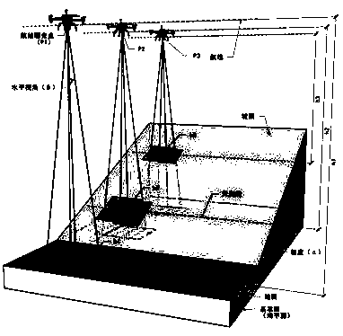
[0034] The method of the present invention is respectively implemented in artificial slopes and natural mountains in the Beichuan area, and the slope height is 75m, the slope length is 150m, and the slope ratio is 1 / 2.

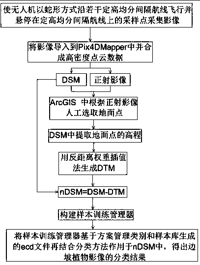
[0035] Such as figure 1 As shown, a UAV slope vegetation classification method based on plant height includes the following steps:

[0036] (1) if figure 2 As shown in Fig. 1, make the UAV fly along several fixed-altitude and evenly spaced routes in a serpentine manner and hover over the sampling points on the fixed-altitude and evenly spaced routes to collect images (such as Figure 4 As shown), a number of fixed-height and evenly spaced air route...


PUM


Abstract

The invention discloses an unmanned aerial vehicle side slope vegetation classification method based on plant height. The method comprises the following steps: (1) enabling an unmanned aerial vehicleto fly along a plurality of fixed-height equally-divided interval airlines in a snake-shaped manner and suspend at sampling points on the fixed-height equally-divided interval airlines to acquire images; (2) importing the image into a Pix4DMapper and synthesizing the image into high-density point cloud data; obtaining a DSM and an ortho-image according to high-density point cloud data, importing the DSM and the ortho-image into an ArcGIS, manually selecting a ground point in the ArcGIS according to the ortho-image, extracting the elevation of the ground point from the DSM, and generating a DTMby using an inverse distance weight interpolation method, wherein nDSM=DSM-DTM, nDSM is the height of the plant, the DSM is a digital surface model and the DTM is a digital terrain model; (3) constructing a sample training manager; (4) applying an ecd file generated by the sample training manager based on the scheme management category and the sample library to the ortho-image in combination witha classification method to obtain a classification result of the slope plant image. According to the method, the classification precision reaches 90%.

Description

technical field [0001] The invention relates to a plant height-based method for classifying vegetation on slopes by UAVs. The method for classifying vegetation on slopes by UAVs is based on the fact that UAVs fly on slopes and obtain clear images. Background technique [0002] Slope ecological engineering includes six main links: planning and design, project construction, project supervision, project acceptance, project management and engineering research, among which the development of the four links of project supervision, project acceptance, project management and project research needs to focus Spatial distribution, whether it is the process and quality in project supervision, or the stability assessment in project acceptance, to the maintenance, replanting, thinning and growth management in project management, or the spatial pattern of groups in engineering research, Biodiversity succession, ecological evaluation, etc., all require dynamic and high-frequency plant spati...

Claims


Application Information

Patent Timeline
IPC IPC(8): G06K9/00G06K9/62
CPCG06V20/188G06F18/24G06F18/24323
Inventor 韩超杨寅郭科
Owner GUIZHOU TRANSPORTATION PLANNING SURVEY & DESIGN ACADEME
Why Eureka
Try Eureka