
Sea surface image semantic segmentation method based on space constraint hybrid model capable of being simplified

A mixed model and space-constrained technology, applied in the field of image processing, can solve problems such as only sky areas, sea water areas, potential obstacle areas, and errors

Pending Publication Date: 2019-10-22
SHANGHAI UNIV
View PDF3 Cites 0 Cited by
  • Summary
  • Abstract
  • Description
  • Claims
  • Application Information

AI Technical Summary

Problems solved by technology

This method has better detection performance and faster speed; however, by observing the sea surface images taken by the unmanned surface vehicle, it can be found that when the unmanned surface vehicle is driving away from the coast, the sea surface image usually only has the sky area, sea water area and potential obstacles area, there is no middle coast / haze mixed area assumed by Kristan et al. Therefore, the semantic segmentation results of the method proposed by Kristan et al.

Method used


Image

  • Sea surface image semantic segmentation method based on space constraint hybrid model capable of being simplified
  • Sea surface image semantic segmentation method based on space constraint hybrid model capable of being simplified
  • Sea surface image semantic segmentation method based on space constraint hybrid model capable of being simplified

Examples


Embodiment 1

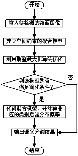
[0073] Such as figure 1 As shown in , a semantic segmentation method for sea surface images based on a simplified spatially constrained hybrid model, the specific implementation steps are as follows:

[0074] (1) Input the color image of the sea surface to be detected;

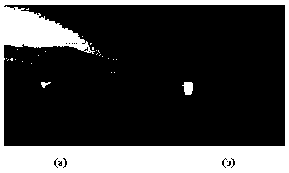
[0075] The color image of the sea surface (with a resolution of 512×512) was obtained by the camera carried by the unmanned surface vehicle. In order to reduce the execution time of subsequent algorithms, the sea surface image is scaled to a resolution of 100×100. Such as figure 2 a shows the image of the sea surface to be detected in this embodiment, and the images used mainly include the sky, the coast, sea waves, and obstacle buoys.

[0076] (2) Assume that there are three main semantic areas of sky, coast / haze, and sea water in the sea surface image, as well as potential obstacle areas, and establish a hybrid model of spatial constraints;

[0077] It is assumed that the mixture model consists of 3 Gau...

Embodiment 2

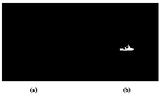
[0106] image 3 It is a preferred embodiment of the method of the present invention under the background of no coast / haze. Its specific implementation steps are the same as those in Embodiment 1, so they are not repeated here. As can be seen from the semantic segmentation results of Embodiment 1 and Embodiment 2, the method of the present invention can automatically select whether to simplify the mixed model of space constraints according to the actual situation of the sea surface image, thereby improving the accuracy of the semantic segmentation of the sea surface image .


PUM


Abstract

The invention discloses a sea surface image semantic segmentation method based on a space constraint hybrid model capable of being simplified. The sea surface image semantic segmentation method comprises the following steps: (1) inputting a sea surface color image to be detected; (2) supposing that the sea surface image has three main semantic regions including sky, coast / haze and seawater and a potential obstacle region, and establishing a spatial constraint hybrid model according to the three main semantic regions; (3) optimizing the spatial constraint hybrid model by using an expectation maximization algorithm (EM); (4) calculating a KL distance (Kullback-Leibler divergence) of Gaussian distribution of sky, coast / haze categories, and if the KL distance is smaller than a set threshold value, simplifying the spatial constraint hybrid model; and (5) outputting a sea surface image semantic segmentation result. According to the method, semantic segmentation can be effectively carried outon the sea surface image, and the method has the advantages of being high in speed and good in robustness.

Description

technical field [0001] The invention relates to the technical field of image processing, in particular to a sea surface image semantic segmentation method based on a simplified space-constrained mixed model. Background technique [0002] Image semantic segmentation is a basic technology for computer vision understanding. Its task is to segment different objects in the image from the perspective of pixels and semantically label each pixel (that is, classify). Applying semantic segmentation technology to sea surface images can help enhance the perception of the surrounding environment of unmanned surface vehicles, thereby ensuring their safe operations. [0003] In recent years, with the rapid development of deep learning, the semantic segmentation method based on convolutional neural network has been widely researched and applied in the fields of unmanned driving and medical image analysis. However, there are few related studies on semantic segmentation of sea surface images...

Claims


Application Information

Patent Timeline
IPC IPC(8): G06T7/11G06T7/143G06K9/62
CPCG06T7/11G06T7/143G06T2207/10024G06T2207/30184G06F18/22G06F18/2155
Inventor 刘靖逸李恒宇沈斐玲罗均谢少荣
Owner SHANGHAI UNIV
Learn More