Aboveground vegetation ecological water estimation method based on airborne LiDAR (Light Detection And Ranging) and Sentinel-2A data

An ecological water and vegetation technology, applied in the research field of vegetation ecological water, can solve the problems of large workload, inability to study vegetation ecological water, low sample collection efficiency, etc., and achieve the effect of improving accuracy

Active Publication Date: 2019-10-25
CHENGDU UNIVERSITY OF TECHNOLOGY
View PDF6 Cites 6 Cited by
  • Summary
  • Abstract
  • Description
  • Claims
  • Application Information

AI Technical Summary

Problems solved by technology

[0005] The traditional method of estimating vegetation ecological water in plot inventory is completely unfeasible. This method has a large amount of field work, a long work cycle, and low sample collection efficiency. It is difficult to conduct a continuous field vegetation ecological water survey. It is highly disturbing and destructive, and has the defect of being unable to conduct research on a wide range of vegetation ecological water
At present, the estimation of vegetation ecological water by optical remote sensing is relatively mature. However, the shortcomings are as follows: first, due to the influence of atmospheric activities or in mountainous areas with thick clouds, optical remote sensing images cannot continuously obtain high-quality images; second, due to the measurement principle of optical images , the vegetation ecological water information can be effectively obtained in the horizontal structure, but the ecological water information of the vegetation stems and branches cannot be obtained. The calculation of the vegetation ecological water by using optical remote sensing images is exactly the measurement of the vegetation canopy ecological water. Therefore, a single passive optical Estimation of vegetation ecological water by remote sensing data has a large error

Method used


Image

  • Aboveground vegetation ecological water estimation method based on airborne LiDAR (Light Detection And Ranging) and Sentinel-2A data
  • Aboveground vegetation ecological water estimation method based on airborne LiDAR (Light Detection And Ranging) and Sentinel-2A data
  • Aboveground vegetation ecological water estimation method based on airborne LiDAR (Light Detection And Ranging) and Sentinel-2A data

Examples


Embodiment Construction

[0047] The following will clearly and completely describe the technical solutions in the embodiments of the present invention with reference to the accompanying drawings in the embodiments of the present invention. Obviously, the described embodiments are only some, not all, embodiments of the present invention. Based on the embodiments of the present invention, all other embodiments obtained by persons of ordinary skill in the art without making creative efforts belong to the protection scope of the present invention.

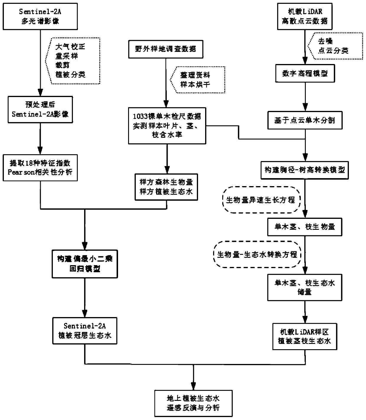
[0048] The present invention provides a method for estimating ecological water of ground vegetation based on airborne LiDAR and Sentinel-2A data, comprising the following steps:

[0049] Step S10: Select the research area and collect field survey data. The size of the field survey sample is a square sample of 10m*10m, and a high-precision handheld GPS is used to record the longitude and latitude coordinates of the center of the sample. For individual trees, re...


PUM


Abstract

The invention relates to an aboveground vegetation ecological water estimation method based on airborne LiDAR and Sentinel-2A data, solves the hydrological effect problem of vegetation from a macroscopic level, undoubtedly is beneficial exploration and attempt, and comprises the following steps: step S10, selecting a research area, and collecting field sample plot survey data; s20, 18 characteristic indexes are extracted from Sentinel-2A remote sensing data, and a vegetation canopy ecological water model is constructed; s30, according to the field survey data, a nonlinear model is adopted to construct a coniferous tree and broad-leaved tree breast height-tree height conversion model; step S40, acquiring single-tree vertical structure information through airborne LiDAR data; s50, constructing an airborne LiDAR vegetation stem and branch ecological water inversion model; and step S60, combining the Sentinel-2A vegetation canopy ecological water with airborne LiDAR vegetation stem and branch ecological water to obtain an above-ground vegetation ecological water reserve result. Compared with a single passive remote sensing source, the above-ground vegetation ecological water reserve result has the advantage that the accuracy of the above-ground vegetation canopy, stem and branch ecological water estimation technology is greatly improved.

Description

technical field [0001] The invention relates to the technical field of research on vegetation ecological water, in particular to a method for estimating aboveground vegetation ecological water based on airborne LiDAR and Sentinel-2A data. Background technique [0002] The invention relates to the technical field of research on vegetation ecological water, and belongs to a method for estimating aboveground vegetation ecological water based on airborne LiDAR and Sentinel-2A data. [0003] Ecological water (layer) refers to the water body closely related to the vegetation body, specifically, the amount of water conserved or intercepted by the vegetation leaf surface, root system, humus layer, surface root soil layer, and vegetation body. Ecological water (layer) can be divided into three parts: the water intercepted in different forms of precipitation by the vegetation layer (leaf surface, root system, humus layer) with vegetation as the main body; The unsaturated water retain...

Claims


Application Information

Patent Timeline
Patent Type & Authority Applications(China)
IPC IPC(8): G06T7/155
CPCG06T7/155G06T2207/10028G06T2207/10032
Inventor 杨武年刘睿杨鑫赵芩文艳罗新蕊张宇航刘亮陈超
Owner CHENGDU UNIVERSITY OF TECHNOLOGY
Why Eureka
Try Eureka