Tight coupling positioning system and method using visual images and GNSS ranging signals

A tightly coupled and visual technology, applied in the field of navigation and positioning, can solve the problems of decreased positioning performance and availability, and achieve the effects of easy promotion and application, improved availability and reliability, and low construction and maintenance costs

Pending Publication Date: 2019-11-26
WUHAN UNIV
View PDF6 Cites 10 Cited by
  • Summary
  • Abstract
  • Description
  • Claims
  • Application Information

AI Technical Summary

Problems solved by technology

[0012] Aiming at the problem that GNSS is blocked or interfered, the positioning performance and usability decrease, ...

Method used


Image

  • Tight coupling positioning system and method using visual images and GNSS ranging signals
  • Tight coupling positioning system and method using visual images and GNSS ranging signals
  • Tight coupling positioning system and method using visual images and GNSS ranging signals

Examples


Embodiment

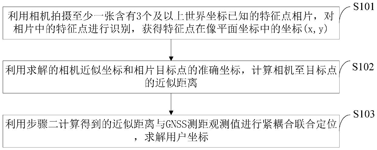
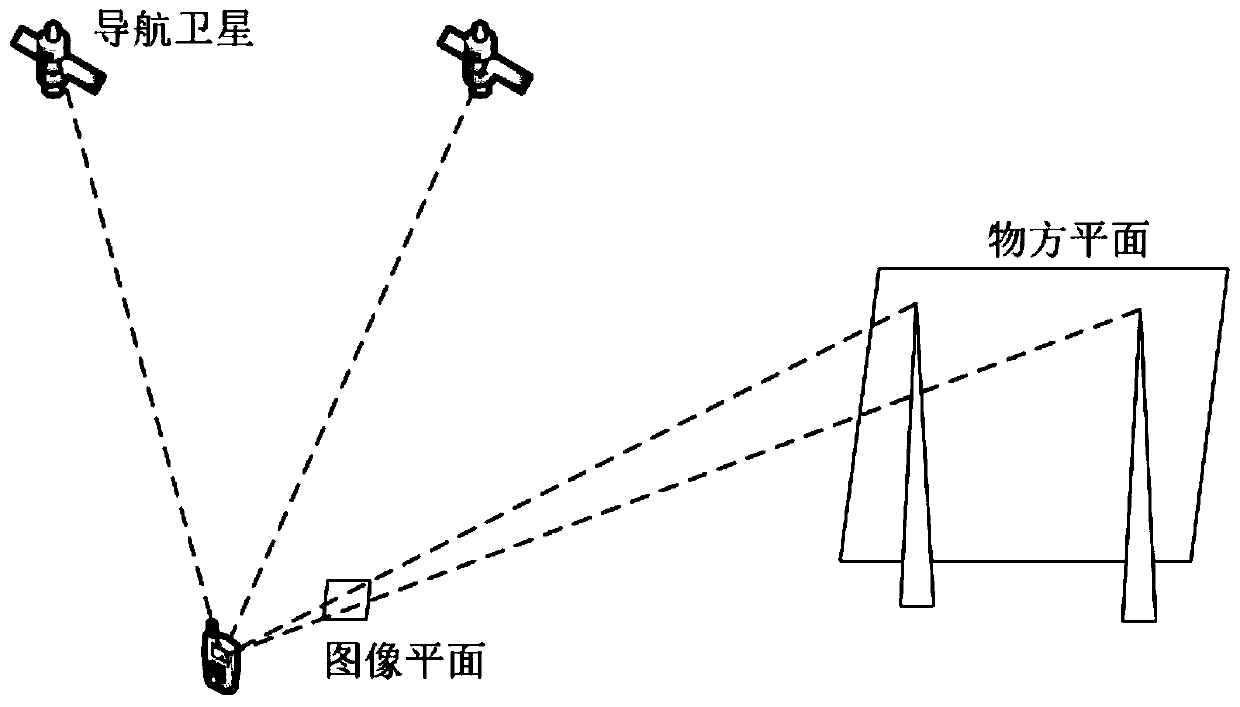
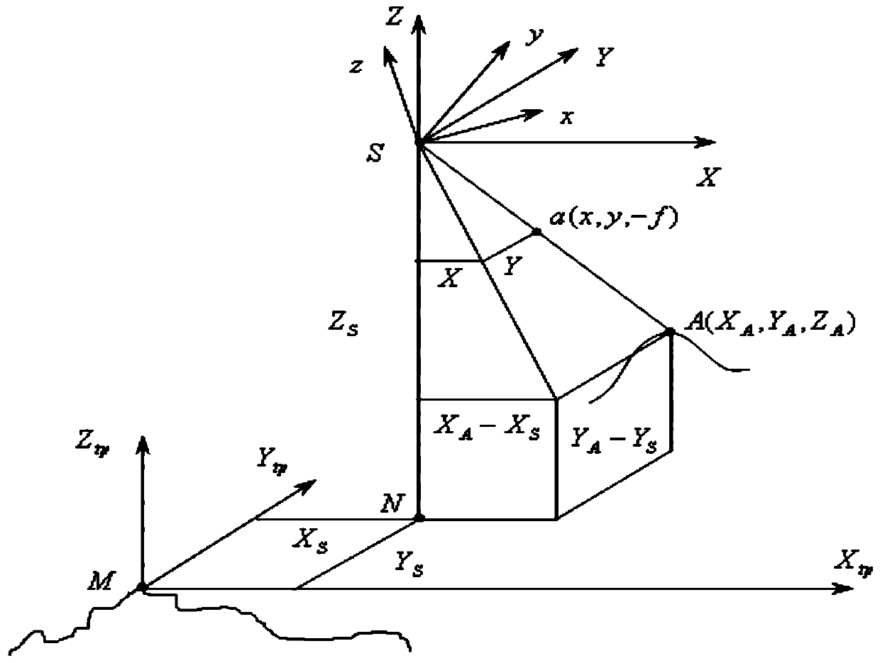
[0078] According to a certain number of "visual base stations" with reasonable distribution in the image coverage area (the coordinates of their image points and ground points are known), use the collinear condition equation to solve the orientation elements Xs, Ys, Zs, ψ, ω, κ outside the image . Before solving the outer orientation elements, it is necessary to accurately calibrate the inner orientation elements of the camera by using the grid marker points to eliminate the influence of lens distortion. In the following introduction, it is assumed that the internal parameters of the camera have been calibrated in advance and the lens parameters have been properly calibrated.

[0079] The first step is to identify the feature points in the photo. The method of feature point identification in the photo can use a relatively mature algorithm, such as the Gaussian Laplacian operator detection method (LOG), Hessian matrix determinant method (DOH) , Scale invariant feature transfor...


PUM


Abstract

The invention belongs to the technical field of navigation and positioning, and discloses a tight coupling positioning system and method using visual images and GNSS ranging signals. The method comprises the steps of shooting three or more feature points with known world coordinates by a camera to calculate the distance from the camera to the feature points; and performing tight coupling joint positioning by using the calculated approximate distance and a GNSS ranging observation value, and solving coordinates of a user. According to the invention, the availability, reliability and anti-interference performance of GNSS positioning can be improved in complex geographical and electromagnetic environments; and the GNSS ranging signals can be utilized to improve the positioning precision of the camera in turn. The image feature points are regarded as visual base stations, and the base station layout cost is not needed. The method is suitable for mobile phones and other portable devices, the user terminal cost is low, and the method can be used for solving the positioning problem of urban canyons and other complex environments. According to the method, the positioning service can be provided under the condition that the GNSS cannot perform positioning independently, so that the availability of the positioning service is improved.

Description

technical field [0001] The invention belongs to the technical field of navigation and positioning, and in particular relates to a tightly coupled positioning system and method using visual images and GNSS ranging signals. Background technique [0002] Currently, the closest prior art: [0003] Satellite navigation technology can provide positioning results in most outdoor situations, but it is still unable to obtain reliable positioning results under conditions such as occlusion and electromagnetic interference. On the other hand, with the emergence of electronic countermeasures such as electronic stations and navigation warfare, the reliability of relying solely on satellite navigation and positioning technology to obtain positions has gradually decreased. In recent years, incidents of GNSS jamming and GNSS spoofing have occurred frequently. Although the four major global satellite navigation systems such as GPS, Beidou, GLONASS, and Galileo have been put into operation or...

Claims


Application Information

Patent Timeline
IPC IPC(8): G01S19/45
CPCG01S19/45
Inventor 王磊陈锐志付文举许钡榛李涛周海涛韩毅申丽丽
Owner WUHAN UNIV
Why Eureka
Try Eureka